• Skip to primary navigation
  • Skip to main content
  • Skip to primary sidebar

Weatherboy

Weatherboy Weather News, Maps, RADAR, Satellite, and Forecasts.

  • Local
  • Earth Science News
  • RADAR
  • Current Warnings
  • Satellite
  • Current Maps
  • Forecast Maps
  • Video

Tropical Storm Jose Being Absorbed By Franklin’s Remnants while Gert is Re-Born

by Weatherboy Team Meteorologist - September 1, 2023

Jose is in the process of being absorbed by what's left of Franklin while Gert is re-born. Image: NHC
Jose is in the process of being absorbed by what’s left of Franklin while Gert is re-born. Image: NHC

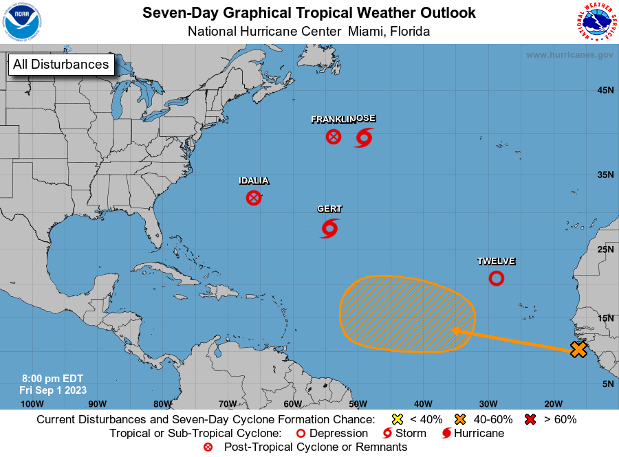
There’s quite the tropical cyclone traffic jam across the Atlantic Hurricane basin, with a variety of tropical cyclones or their remnants moving about. Tropical Storm Gert is in the process of being absorbed by what’s left of Hurricane Franklin. Meanwhile ahead of what’s left of Hurricane Idalia is Tropical Storm Gert, which re-formed into a tropical storm again after losing tropical storm status in August. Gert will spin over the central Atlantic this weekend, far away from any land. Tropical Depression #12 has formed west of Africa and is forecast to become a named tropical storm briefly before dissipating later over the weekend. Lastly, the National Hurricane Center is tracking a tropical wave moving off the coast of Africa that could become a tropical cyclone next week.


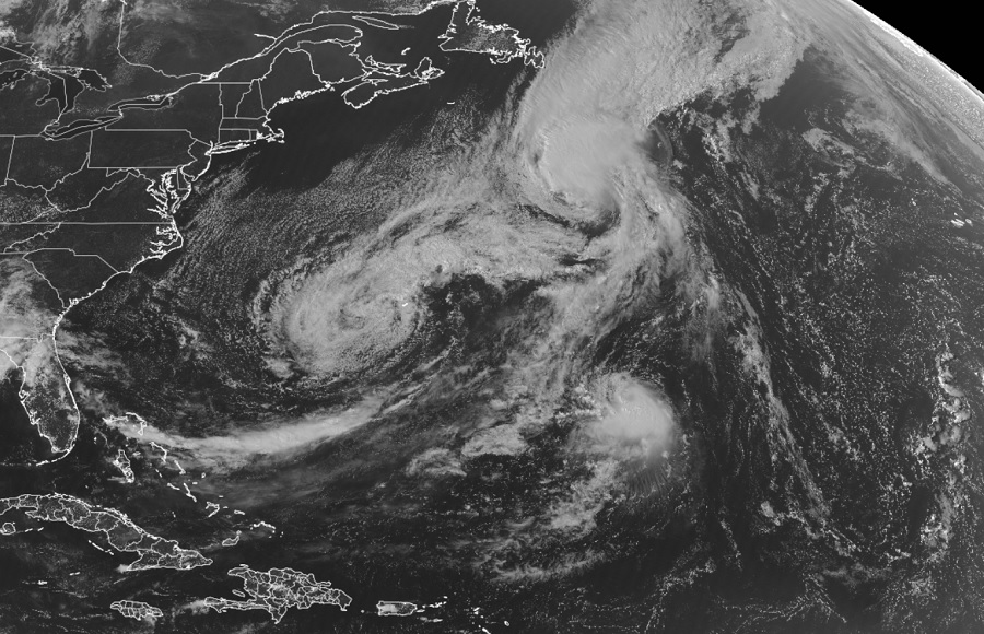
Jose is moving underneath the upper-level clouds associated with Franklin’s outflow while it continues to accelerate towards the north-northeast at about 30 mph. The increase in forward motion and interaction with Franklin could lead to a slight expansion of the tropical-storm-force winds on the east side of Jose. However, Jose is still expected to dissipate sometime tonight as it becomes absorbed by Franklin.

Current satellite view shows lots of tropical cyclone activity over the Atlantic, but no active threats to the U.S. at this time.  Image: NOAA
Current satellite view shows lots of tropical cyclone activity over the Atlantic, but no active threats to the U.S. at this time. Image: NOAA


The National Hurricane Center is tracking a tropical wave moving off the coast of Africa. They say environmental conditions appear conducive for some gradual development of this system during the early and middle parts of next week, and a tropical depression could form while it moves westward to west-northwestward at 15 to 20 mph over the eastern and central portions of the tropical Atlantic. There’s only a 10% chance of formation over the next 48 hours, but those odds grow to 60% over the next 7 days.

Primary Sidebar

Sponsored Ad

Search

Latest News

  • July to Start with Severe Weather Event in New Jersey, Pennsylvania, Delaware, & Maryland
  • Tropical Storm Barry Forms; Additional Storm Possible Near Florida
  • Severe Weather Threat & Tornado Risk Returns to Northeast Today
  • Hurricane Center Monitoring Possible Gulf Disturbance
  • Bolide Explodes over Southeastern United States; Piece Crashes into Home
  • 88 Earthquakes Strike Puerto Rico and Dominican Republic; No East Coast Tsunami Threat
  • Andrea Fades Away; No Other Tropical Cyclone Threats around US
  • Tropical Storm Andrea Forms Kicking Off the 2025 Atlantic Hurricane Season
About | Careers | Contact | Contests
Terms | Privacy | Ad Choices
Weatherboy is a (R) Registered Trademark of isarithm LLC, All Rights Reserved.
All content herein is Copyright by Isarithm LLC 1997-2022