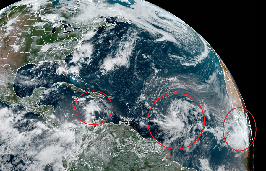
The tropical Atlantic is producing a possible triple threat of new tropical cyclones that are marching east to west across the ocean. In their latest Tropical Outlook, the Miami, Florida – based National Hurricane Center (NHC) says they are monitoring the three systems for potential tropical cyclone development, development they say is likely with at least 2 of the 3 systems in the next day or two.
A tropical cyclone is the generic term for a non-frontal synoptic scale low-pressure system over tropical or sub-tropical waters with organized thunderstorm activity and a definitive cyclonic surface wind circulation. In waters around the United States, tropical cyclones begin as tropical depressions. Once a tropical depression’s maximum sustained winds grow to 39 mph, the system is classified as a “tropical storm” and is given a name from the list of storm names the NHC uses each year. Once maximum sustained winds reach 74 mph, the system is re-classified as a “hurricane.” If winds reach or exceed 110 mph, the system is known as a “major hurricane.”
If the three systems that the National Hurricane Center became tropical storms, they would be named Laura, Marco, and Nana; if they were to form this week, they would shatter records for being the earliest “L”, “M”, and “N” storm formation in the Atlantic basin on record.
According to the NHC, showers and thunderstorms have become more concentrated today in association with a tropical wave currently located over the central Caribbean Sea. Some gradual development of this system is possible over next day or so while it moves westward at about 15 to 20 mph across the central Caribbean Sea. After that time, the wave is forecast to move more slowly west-northwestward, and a tropical depression is likely to form later this week when the system reaches the northwestern Caribbean Sea. The NHC believes there is now an 80% chance that a tropical cyclone will form here within the next 5 days. Some global computer forecast models suggest this storm could eventually become a threat in the Gulf of Mexico, but it is too soon to say with any certainty where this storm will go or how strong it’ll become.
A more impressive system on satellite view is located in the central Atlantic, roughly 1,000 miles east of the Windward Islands. As an elongated area of low pressure today, the system continues to produce a concentrated area of showers and thunderstorms. Although recent satellite-derived wind data indicates that the low is not well-defined, the NHC says environmental conditions are conducive for further development, and a tropical depression is expected to form during the next day or two while the system moves generally west-northwestward at 15 to 20 mph across the central and western portions of the tropical Atlantic. In the latest Tropical Outlook, the NHC says there’s a 90% chance that a tropical cyclone will form here.
As with the first system, it is too soon to tell where this system will go or how strong it’ll get. However, global computer model forecasts suggest it will grow into a hurricane and potentially impact the U.S. East Coast in time.
The third area being monitored for potential tropical cyclone development is a a large area of showers and thunderstorms located over Guinea and Sierra-Leone, Africa. Associated with a vigorous tropical wave, environmental conditions are expected to be conducive for some development of this system while the wave enters the extreme eastern Atlantic on Friday. Because the system is still over land, it is too soon to say how this system will evolve over time.