Their continues to be tropical trouble in the Atlantic Hurricane Basin with Harvey and a system that’ll eventually become Irma. Harvey, which made landfall over Texas on August 25, continues to drop epic rain on portions of Texas and Louisiana. More than 49″ of rain already fell near the Houston metro area with more on the way. Meanwhile, two systems have attracted the attention of meteorologists in the Atlantic and one will be named Irma soon.
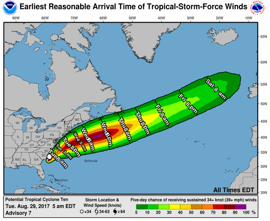
Just off the US East Coast is Potential Tropical Cyclone #10. It was originally expected to intensify to a tropical storm and be named Irma, the next name to be used for Atlantic basin storms. However, the system has struggled to become better organized and failed to gain additional tropical characteristics to be considered a tropical cyclone. While the National Hurricane Center (NHC) thought this system had a 90% chance of becoming a tropical cyclone yesterday, those odds have dropped to 40% today.
Potential Tropical Cyclone #10 developed a center that has been trackable since last evening; however, it is still not well-defined, since it appears to be considerably elongated northeast-southwest. The disturbance continues to display very cold, but extremely asymmetric deep convection with all of the thunderstorm activity east of the center due to strong vertical shear. Moreover, the convection is showing no identifiable banding features. Regardless of the label the National Hurricane Center uses to describe this hybrid system, maximum winds are around 35 kt. The initial motion of the disturbance is northeast at a faster rate of about 10 kt. Continued acceleration is expected during the next couple of days as a mid- to upper-level trough over the Great Lakes moves closer to the system. The NHC forecast track takes the disturbance across the North Carolina coastline today. By tonight, the cyclone is forecast to move offshore and accelerate over the Atlantic in the mid-latitude westerlies. The system is expected to become extratropical in 24 hours or less when it interacts with the aforementioned mid- to upper-level trough. Significant strengthening as an extratropical cyclone is forecast for a couple of days due to baroclinic forcing. Unless the system can pull itself together today and gain tropical cyclone characteristics, it won’t ever be named. If it beats the odds and becomes a named cyclone, it would be labeled Irma.
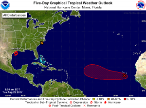
If Potential Tropical Cyclone #10 doesn’t become Irma, a new strong disturbance in the Atlantic will. Showers and thunderstorms associated with a low pressure area near the Cabo Verde Islands have become better organized since yesterday. According to the NHC, environmental conditions are conducive for development, and a tropical depression is expected to form in 2 or 3 days over the eastern Atlantic. The low is forecast to move generally west-northwest at 15 to 20 mph over the tropical Atlantic during the next several days. Some long range guidance suggests this system could become a threat to the US East Coast; however, it is much too soon to have a high degree of confidence in a forecast so far away. In the meantime, heavy rain is possible over portions of the Cabo Verde Islands through Wednesday.
If this system in the Atlantic becomes the next named tropical cyclone, it will be called Irma. If Potential Tropical Cyclone #10 is able to earn the name first, the system in the Atlantic would be called Jose.
The traditional peak of the Atlantic Hurricane Season is on/around September 10; as such, we expect more tropical activity to pop-up in the basin over the coming days and weeks.
Experts believe this Atlantic Hurricane Season, which runs through to the end of November, will be a busy one. Dr. Phil Klotzbach and the experts at Colorado State University updated their seasonal outlook again on July 5, showing a much more active than normal season expected. The National Oceanic and Atmospheric Administration (NOAA) also released their own forecast which shows this hurricane season to be likely more active than others.
