• Skip to primary navigation
  • Skip to main content
  • Skip to primary sidebar

Weatherboy

Weatherboy Weather News, Maps, RADAR, Satellite, and Forecasts.

  • Local
  • Earth Science News
  • RADAR
  • Current Warnings
  • Satellite
  • Current Maps
  • Forecast Maps
  • Video

Two Tropical Threats

by Weatherboy Team Meteorologist - June 18, 2017

Latest visible satellite map shows two areas of concern being tracked by the National Hurricane Center. Either or both of these storms have the potential of impacting the US as a named tropical cyclone in the coming days. Image: Weatherboy.com

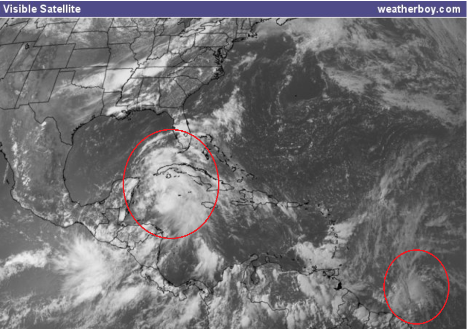
The National Hurricane Center is tracking two tropical threats within the Atlantic Hurricane Basin. One is about 800 miles east southeast of the southern Winward Islands and the other is near the east coast of the Yucatan Peninsula.

Tropical Storm Watches have been issued for portions of the Caribbean ahead of Potential Tropical Cyclone #2.  Map: National Hurricane Center
Tropical Storm Watches have been issued for portions of the Caribbean ahead of Potential Tropical Cyclone #2. Map: National Hurricane Center

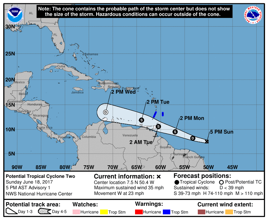
The National Hurricane Center began issuing advisories for Potential Tropical Cyclone #2 at 5pm on June 18; this is the first time that the National Hurricane Center issued advisories for a storm that has yet to officially form. Showers and thunderstorms associated with a tropical wave  have become a little better organized since yesterday. Some additional development of this system is possible during the next couple of days before environmental conditions become less favorable for tropical cyclone formation. This system is forecast to move to the west-northwest at near 20 mph toward the Windward Islands and northeastern South America during the next two days, and interests in these areas should monitor its progress. Regardless of development, locally heavy rains and gusty winds are likely to spread over portions of the Windward Islands Monday night and Tuesday. An Air Force Reserve Hurricane Hunter aircraft is scheduled to investigate this system on Monday, if necessary. There is a 60% chance that this system will develop over the next 48 hours.


The government of Barbados has issued a Tropical Storm Warning for Barbados, St. Vincent, and the Grenadines ahead of Potential Tropical Cyclone #2. Additional watches or warnings may be needed over time for this system.
Meanwhile, attention is also being paid on a tropical system closer to the United States. Surface observations and satellite data indicate that a broad low pressure area is centered near the east coast of the Yucatan Peninsula. This system is producing a large area of showers and thunderstorms along with winds to gale force several hundred miles to the east and northeast of the center. However, the low lacks a well-defined center of circulation, and the Hurricane Hunter mission scheduled for this afternoon has been canceled. Gradual development is expected while the low moves slowly north-northwestward across the Yucatan Peninsula through tonight, and then over the southern or central Gulf of Mexico on Monday and Tuesday, where a tropical or subtropical cyclone is likely to form. Regardless of development, heavy rains are expected over portions of Central America, the Yucatan Peninsula, Jamaica, the Cayman Islands, and western Cuba during the next several days. An Air Force Reserve Hurricane Hunter aircraft is scheduled to investigate this system on Monday, if necessary. There is a 70% chance that this system will develop in the next 48 hours and a 90% chance that it’ll develop in the next 5 days.


Experts believe this Atlantic Hurricane Season, which runs through to the end of November, will be a busy one.  Dr. Phil Klotzbach and the experts at Colorado State University recently updated their seasonal outlook to show more storms forming in the Atlantic basin this season. The National Oceanic and Atmospheric Administration  (NOAA) also released their own forecast which shows this hurricane season to be likely more active than others.
Satellite images, forecast models, and the latest advisories for tropical cyclones anywhere near North America can be found on our Hurricanes & Tropical Weather section of this website.

Primary Sidebar

Sponsored Ad

Search

Latest News

  • Snow Drought Persists in Philadelphia, New York City, New Jersey, & Surrounding Areas
  • Earthquakes Rattle Los Angeles Area
  • Rocket Lab Has Spectacular Launch from Mid Atlantic This Evening
  • Mid-Week Winter Storm Expected in Northeast
  • New York City TV Weatherman Beaten-Up on NYC Subway
  • Freak Wind Accident at Denny’s Leaves 1 Dead, 2 Seriously Injured
  • Models Agree Snow is Coming to Mid Atlantic & Northeast, But Completely Disagree How and When
  • Weatherboy Sends Meteorology Students to National Tropical Weather Conference and is About to Do It Again
About | Careers | Contact | Contests
Terms | Privacy | Ad Choices
Weatherboy is a (R) Registered Trademark of isarithm LLC, All Rights Reserved.
All content herein is Copyright by Isarithm LLC 1997-2022