According to USGS, there are four volcanoes around the United States and its interests that are erupting or may soon erupt, prompting them to issue bulletins alerting people of the heightened unrest being exhibited by the volcanoes.
USGS is responsible for monitoring volcanoes and earthquakes around the United States and its territories. Today, of the volcanoes it is monitoring, it has two at an alert level of WATCH and a color code of ORANGE while it has two others at an alert level of ADVISORY and a color code of YELLOW. The 4 volcanoes around the U.S. with the heightened alert level are Great Sitkin in Alaska (WATCH/ORANGE), Spurr in Alaska (ADVISORY/YELLOW), Kilauea in Hawaii (WATCH/ORANGE), and the Ahyi Seamount near the Northern Marianas (ADVISORY/YELLOW). All of the other volcanoes USGS is monitoring today are either at GREEN or unrated conditions.
Within the United States, the USGS tracks dozens of potentially active volcanoes, most of which are in Alaska. In Alaska alone, there are more than 130 volcanoes and volcanic fields which have been active within the geologically young last 2 million years. 50 have been active since the mid 1700s and the Alaska Volcano Observatory (AVO) studies those too.
The U.S. is only home to a fraction of the world’s volcanoes: according to USGS, there are normally around 2 dozen erupting volcanoes around the world at any given time. The USGS says there are about 1,500 potentially active volcanoes worldwide, with about 500 of the 1,500 erupting in modern historical times.
The Hawaii volcanoes are monitored by the Hawaii Volcano Observatory (HVO) while the Alaska volcanoes are monitored by the Alaska Volcano Observatory (AVO.) In addition to the AVO and HVO, there are also the California Volcano Observatory , Cascades Volcano Observatory, the Yellowstone Volcano Observatory, and the Northern Mariana Islands Volcano Observatory. Each of those additional volcano observatories within the USGS are monitoring volcanoes in their respective regions. At this time, none of those other observatories on the U.S. mainland are reporting unusual activity or signs of anything more than background noise for now.
In the U.S., the USGS and volcano observatory units are responsible for issuing Aviation Codes and Volcanic Activity Alert Levels. Aviation Codes are green, yellow, orange, or red. When ground-based instrumentation is insufficient to establish that a volcano is at a typical background level of activity, it is simply “unassigned.” While green means typical activity associated with a non-eruptive state, yellow means a volcano is exhibiting signs of elevated unrest above known background levels. When a volcano exhibits heightened or escalating unrest with the increased potential of eruption, it jumps to orange. Finally, when an eruption is imminent with significant emission of volcanic ash expected in the atmosphere or an eruption is underway with significant emission of volcanic ash into the atmosphere, the code becomes red. Volcanic Activity Alert levels are normal, advisory, watch, or warning. As with aviation codes, if data is insufficient, it is simply labeled as “unassigned.” When the volcano is at typical background activity in a non-eruptive state, it is considered normal. If the volcano exhibits signs of elevated unrest above background level, an advisory is issued. If a volcano exhibits heightened or escalating unrest, a watch is issued while a warning is issued when a hazardous eruption is imminent.
The Great Sitkin Volcano is a basaltic andesite volcano that occupies most of the northern half of Great Sitkin Island, a member of the Andreanof Islands group in the central Aleutian Islands. It’s located roughly 26 miles east of Adak, which is 1,192 miles southwest of Anchorage. According to the AVO, the volcano has a composite structure consisting of an older dissected volcano and a younger parasitic cone with a 1.8 mile diameter summit crater. A steep-sided lava dome, emplaced during an eruption in 1974, occupies the center of the crater. Within the past 280 years, a large explosive eruption here produced pyroclastic flows that partially filled the Glacier Creek valley on the southwest flank.
According to AVO, lava continues to erupt slowly in the summit crater of Great Sitkin Volcano. Small earthquakes were detected over the past day. Low-level steaming was observed in clear web camera and satellite views of the volcano.
The current eruption of Great Sitkin Volcano began with a single explosive event in May 2021. The ongoing eruption of lava at the summit began shortly afterward, in July 2021. This volcano, currently at WATCH/ORANGE, is monitored using local seismic and infrasound sensors, satellite data and web cameras, and regional infrasound and lightning networks.

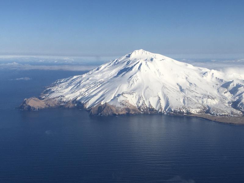
Mount Spurr is also showing unrest. Mount Spurr is a stratovolcano in the Aleutian Arc of Alaska, named after USGS geologist and explorer Josiah Edward Spurr, who led an expedition to the area in 1898. Known as the highest volcano of the Aleutian Arc, Spurr consists of a large stratocone constructed at the center of a roughly 3.1 mile wide horseshoe-shaped caldera that is open to the south. The volcano is about 80 miles west of Anchorage.
According to AVO, unrest continues at Mount Spurr, with numerous small, shallow volcanic earthquakes detected beneath the volcano over the past day. Currently, the earthquakes are being located under the Crater Peak vent as well as under the summit of Mount Spurr. AVO continues to monitor activity at Mount Spurr for signals that would indicate that the volcano is moving closer to an eruption. Based on previous eruptions, changes from current activity in the earthquakes, ground deformation, summit lake, and fumaroles would be expected if magma began to move closer to the surface. Therefore, it is very likely that if an eruption were to occur it would be preceded by additional signals that would allow advance warning.
The Spurr volcano is monitored using local seismic, infrasound, web camera, and GNSS stations along with regional infrasound, lightning networks and satellite data.
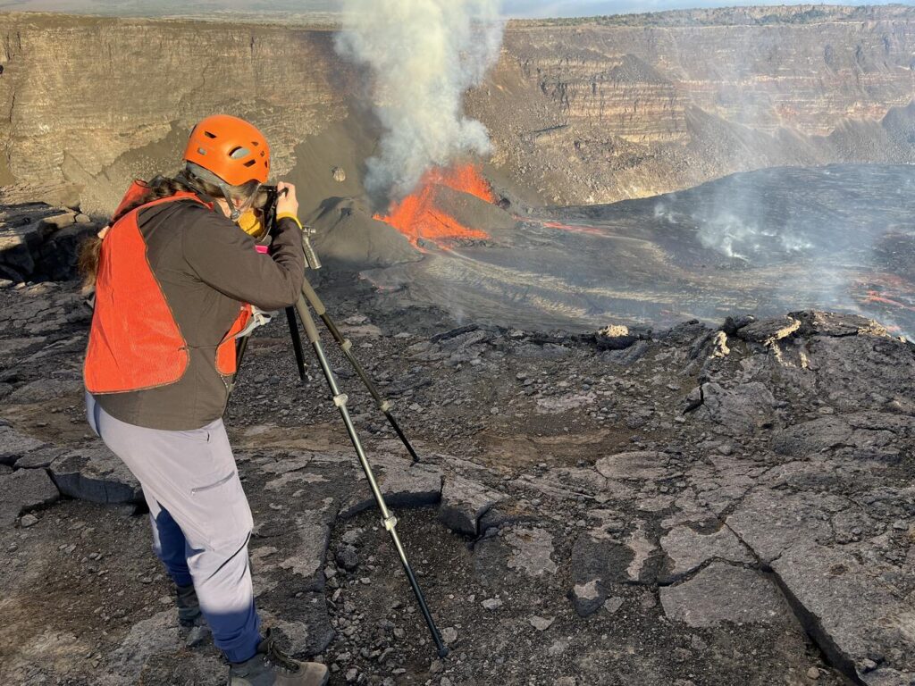
On the Big Island of Hawaii, the Kilauea Volcano has erupted many times since re-starting after a dormant period of December 23. The volcano just completed it’s 9th eruption within this series and HVO scientists believe another eruption event is likely within the next 3-6 days. Each episode characterized by lava fountaining separated by pauses in activity. All recent eruptive activity has occurred in Hawaii Volcanoes National Park. No significant changes have been noted along Kīlauea’s East Rift Zone or Southwest Rift Zone which are closer to populated areas on the island.
With a 10th eruption expected in the days ahead here, HVO has Kilauea at ORANGE/WATCH status.
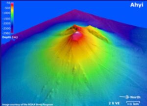
Unrest also continues at the Ahyi Seamount continues. Ahyi is a large conical submarine volcano that rises to within 260 feet of the sea surface about 11 miles southeast of the island of Farallon de Pajaros (Uracas) in the Northern Mariana Islands. USGS reports that water discoloration has been observed over the submarine volcano during previous periods of activity, and in 1979 the crew of a fishing boat felt shocks over the summit area followed by upwelling of sulfur-bearing water.
From April 24 to 25, 2001, an explosive submarine eruption was detected seismically from a seismic station on Rangiroa Atoll, Tuamotu Archipelago. The event was well constrained at a location near the southern base of Ahyi. Another eruption was detected from April 24 to May 17, 2014, using data from seismometers located on subaerial volcanoes in the Northern Mariana Islands and hydrophone arrays at Wake Island. NOAA divers also reported hearing explosions while conducting coral reef research on nearby Farallon de Pajaros. The 2014 eruption of Ahyi formed a new crater near the summit of the volcano and a large landslide chute developed on its southeast flank. More recently, the volcano erupted from October 2022 to May 2023 and again from December 2023 to April 2024, characterized by submarine plumes and geophysical detections of activity on the hydrophone arrays at Wake Island. The current episode of unrest began in August 2024.
No activity was detected in hydroacoustic array data at Wake Island this week. However, a satellite image showed a plume of discolored water in the vicinity of Ahyi on February 8, indicating possible submarine activity. Similar, weak activity at Ahyi Seamount has been observed in satellite imagery off and on extending back to August 5, 2024.
There are no local monitoring stations near Ahyi seamount, which limits USGS’s ability to detect and characterize volcanic unrest there. “We will continue to monitor satellite and distant hydroacoustic data closely for additional evidence for, or escalation of, volcanic activity,” USGS said in a statement today.
