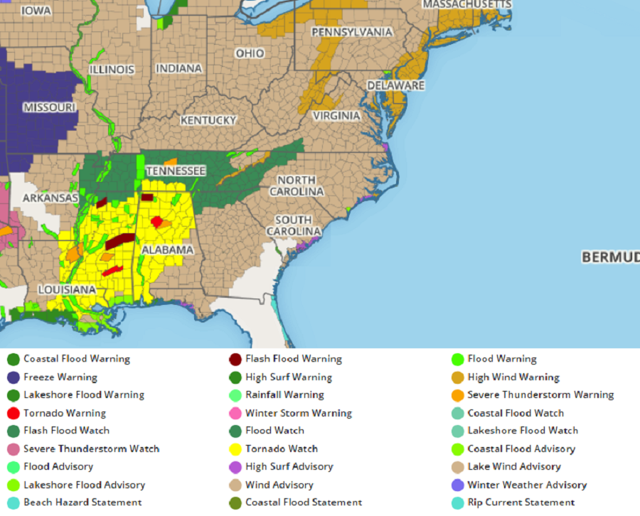
A violent severe weather outbreak continues this Easter Sunday evening with numerous Tornado Watches and Warnings up in the south; a damaging wind event is associated with this storm system is also expected to impact the Mid Atlantic tomorrow, prompting the National Weather Service to issue High Wind Warnings for the New York City and Philadelphia metro areas, as well as much of Connecticut, New Jersey, and Delaware. The life-threatening and property-damaging conditions should wrap up by late tomorrow.
Through midnight tonight local-time, a Particularly Dangerous Situation Tornado Watch has been issued for portions of central and southern Alabama and southeast Mississippi. According to the National Weather Service, numerous tornadoes are expected with a few intense tornadoes likely. Widespread large hail and isolated very large hail events to 3″ in diameter is also likely. Beyond damage from tornadoes, widespread damaging winds gusting to or over 70 mph is likely too. In this area, intense supercells over southern Mississippi will track northeastward across the watch area.
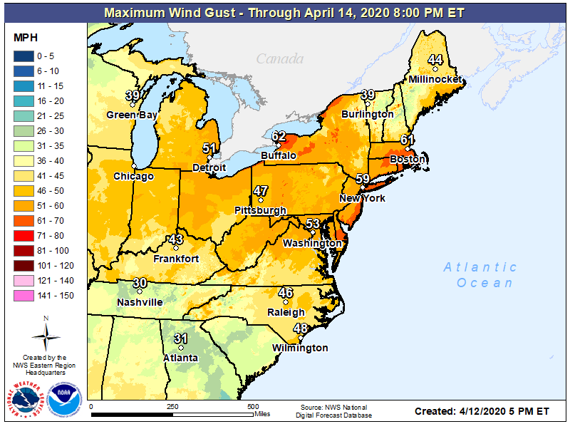
For now, high pressure remains over the western Atlantic waters. The low pressure system over the Mississippi Valley responsible for today’s tornadoes will intensify as it lifts northeast towards the Great Lakes area. Out ahead of this intense low, a very strong low level jet will arrive by daybreak along the Mid Atlantic coast. For much of the eastern United States, south winds will increase to 15-20 mph with gusts to 30 mph this evening, ramping up to 20-30 mph with gusts to 40 mph by daybreak.
Tomorrow, the wind alone could be destructive, especially in portions of Delaware, New Jersey, and Long Island. While a low level inversion should keep most of the stronger winds aloft, periods of heavy rain falling through the atmosphere should help bring some of those strong winds to mix down. Thunderstorms forecast to move through the region will be more efficient in bringing those upper-level winds to the surface, with hurricane force wind gusts in excess of 75 mph possible. The strongest winds will be right along the New Jersey and Delaware coasts, as well as portions of Long Island and southeastern New England. Winds be gusting to 60-70 mph in rain and 70-90 mph in thunderstorms. Further inland, to the I-95 corridor, damaging winds are possible too; there, gusts will range from 50-60 mph with higher gusts possible in thunderstorms. For northern New Jersey, the southern Poconos, Lehigh Valley, and southern Upstate New York, maximum wind gusts will be in the 40-50 mph.
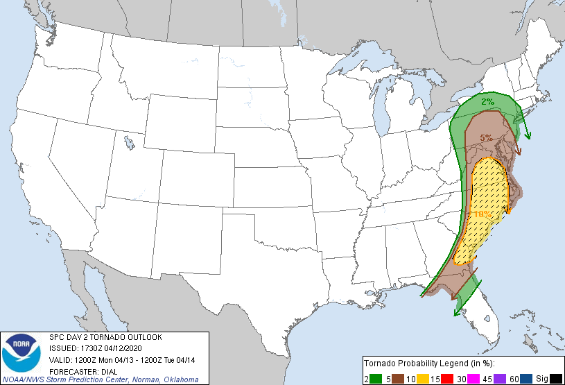
While the threat of tornadoes is focussed on the south now, the threat will shift north and east tomorrow. The threat of tornadoes will exist from north-central Florida up to southern upstate New York State; a greater threat will exist from central Pennsylvania and southern New Jersey south to the Georgia/Florida border. A significant threat exists over eastern Virginia, eastern North and South Carolina, and southeastern Georgia. Tornado Watches and Warnings may be necessary in any of these areas tomorrow.
Beyond tornadoes and wind damage, large hail, frequent lightning, and flash flooding rains are also possible in any of these cells.
While many are sheltering-in-place due to the COVID-19 Pandemic, a place suitable for shelter for the virus may not be suitable for shelter from the severe storms. Before threats arrive, people should make sure they’re in a safe place to protect themselves from severe weather. If people are in places they aren’t used to due to COVID-19, they should review what they would do should destructive straight-line winds or tornadoes impact their place of shelter.
The rough weather will end from southwest to northeast tomorrow evening, with lingering rain, snow, and gusty winds over northern New England the last to depart the U.S. on Tuesday morning.
