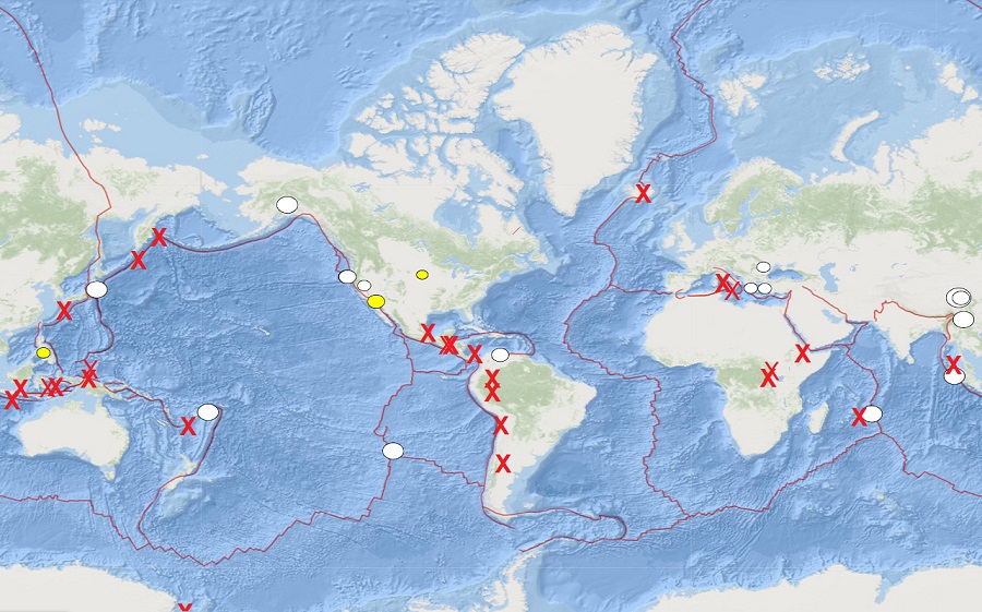
Volcanoes have roared to life around the globe, with every continent but Australia seeing an active eruption today. However, many erupting volcanoes are located just north and east of Australia, keeping volcanologists busy even in that part of the world. There are currently 26 active volcanoes erupting around the world today.
According to the U.S. Geological Survey (USGS), there are about 1,500 potentially active volcanoes worldwide, with about 500 of the 1,500 erupting in historical times. Most of the volcanoes in the world are located around the “Ring of Fire” around the Pacific Rim. The Ring of Fire is a region around the rim of the Pacific Ocean where many volcanic eruptions and earthquakes occur. Caused by plate tectonics, lithospheric plates under and around the Pacific Ocean move, collide, and/or are destroyed, creating the seismic activity the Ring of Fire is famous for.
While most volcanoes occur around borders of moving plates, they can also occur in the middle of plates too. In Hawaii, a hot spot in the middle of the Pacific plate allows magma to reach the surface in a weakness in the plate there. In East Africa, spreading and shifting of plates has created the modern day Middle East there while also creating an area ripe with volcanic activity. While plate tectonics helped sheer Saudi Arabia off of the African continent, creating the Red Sea in the process, the continental crust continues to stretch thin in this area. With the crust thinning there, magma below the surface is able to work its way through cracks and weaknesses in the thin crust, creating many volcanoes there.
Within the United States, the USGS tracks 169 potentially active volcanoes, most of which are in Alaska. Alaska is home to many volcanoes, though; there are more than 130 volcanoes and volcanic fields which have been active within the geologically young last 2 million years. 50 have been active since the mid 1700s and AVO studies those too. Another place famous for its volcanoes is Hawaii; on the Big Island of Hawaii, Kilauea, Mauna Loa, and Hualalai are considered active and potential threats, however none are erupting as of today. Kilauea did start a fresh eruption in December 2020, but that eruption came to an end just weeks ago.
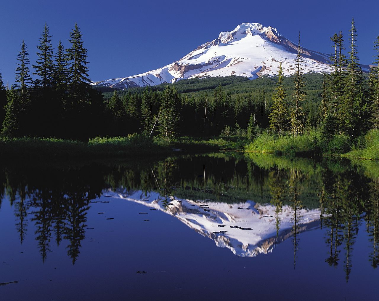
Beyond Hawaii’s volcanoes which are the most active in the U.S., the U.S. has seen three notable eruptions in the western U.S. since the nation was founded. The most famous is Mount St. Helens in Washington which saw eruptions and/or lava dome growth in the late 1700s, 1800-1857, and 2004-2007. The Mount St. Helens eruption of 1980-1986 was by far the most noteworthy in the U.S. Another notable erupting volcano is Lassen Peak in California. A series of steam blasts began on May 30, 1914 and an eruption occurred 12 months later on May 21, 1915. Minor activity continued there through the middle of 1917. After being dormant for over 1,000 years, Mount Hood in Oregon has an eruptive period beginning in 1781 that lasted for about a decade. In the mid 1800s, local residents reported minor explosive activity.
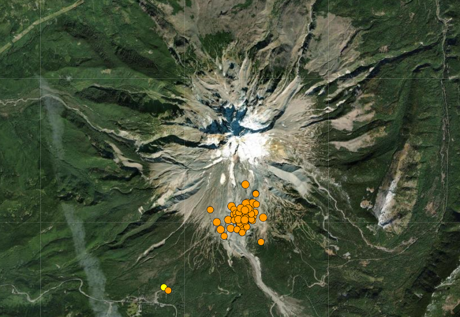
An earthquake swarm impacted the Mount Hood volcano just days ago. While that swarm has ended, it is likely future eruptions will occur again at that active volcano sometime in the future.
New volcanic events have been unfolding in Alaska in recent weeks. The volcano alert level at the Gareloi stratovolcano was raised just days ago. In May, activity at the Great Sitkin Volcano forced scientists to raise the alert level there to the maximum “RED” / “Warning”. The Semisopochnoi Volcano has also had unrest in recent weeks. And in March, the volcanic threat level was raised at the Cleveland Volcano by the USGS.
Volcanoes in this portion of the Ring of Fire are monitored by the Alaska Volcano Observatory (AVO), which is a joint program of the U.S. Geological Survey (USGS), the Geophysical Institute of the University of Alaska Fairbanks (UAFGI), and the State of Alaska Division of Geological and Geophysical Surveys (ADGGS).
The AVO is similar to the Hawaii Volcano Observatory (HVO) which monitors Hawaii’s three active volcanoes: Kilauea, Mauna Loa, and Hualalai. Due to ongoing activity at Hawaii’s Mauna Loa volcano, considered the world’s largest, authorities began warning people this spring of the possibility of a future eruption and the need to plan and prepare for it.
In addition to the AVO and HVO, there are also the California Volcano Observatory , Cascades Volcano Observatory, and the Yellowstone Volcano Observatory. Each of those additional volcano observatories within the USGS are monitoring volcanoes in their respective regions. At this time, none of those other observatories are reporting unusual activity or signs of anything more than background noise for now.
In the U.S., the USGS and volcano observatory units are responsible for issuing Aviation Codes and Volcanic Activity Alert Levels. Aviation Codes are green, yellow, orange, or red. When ground-based instrumentation is insufficient to establish that a volcano is at a typical background level of activity, it is simply “unassigned.” While green means typical activity associated with a non-eruptive state, yellow means a volcano is exhibiting signs of elevated unrest above known background levels. When a volcano exhibits heightened or escalating unrest with the increased potential of eruption, it jumps to orange. Finally, when an eruption is imminent with significant emission of volcanic ash expected in the atmosphere or an eruption is underway with significant emission of volcanic ash into the atmosphere, the code becomes red. Volcanic Activity Alert levels are normal, advisory, watch, or warning. As with aviation codes, if data is insufficient, it is simply labeled as “unassigned.” When the volcano is at typical background activity in a non-eruptive state, it is considered normal. If the volcano exhibits signs of elevated unrest above background level, an advisory is issued. If a volcano exhibits heightened or escalating unrest, a watch is issued while a warning is issued when a hazardous eruption is imminent.
In the U.S. today, Hawaii’s Mauna Loa and Kilauea volcano are at a yellow / advisory level. In Alaska, Semisopochnoi is at an orange / watch level while Gareloi and Cleveland are at a yellow / advisory level. No other volcano in Alaska, Hawaii, or the western U.S. is at any threat level as of today.
While the volcano scene continues to evolve in the United States, volcanoes outside of the U.S. continue to evolve too. In Central America, 5 volcanoes are erupting today: Popocatepetl, Santiaguito, Fuega, Pacaya, and Masaya. Ash erupted from Popocatepetl will sometimes trigger an advisory by the U.S.. In South America, Reventador, Sangay, Sabancaya, and Nevados de Chillan are currently erupting. In Europe, Stromboli and Etna have been very active in recent days. In Africa, Erta Ale, Nyiragongo, and Piton de la Fournaise have been erupting. Well east of the Australia east coast, Yasur is erupting in the Pacific. And in Asia, Sinabung, Merapi, Semeru, Lewotolo, Ibu, Dukono, Sakurajima, Ebeko, and Shiveluch are all erupting today. Even Antarctica is in place, with an eruption ongoing at Erebus there.
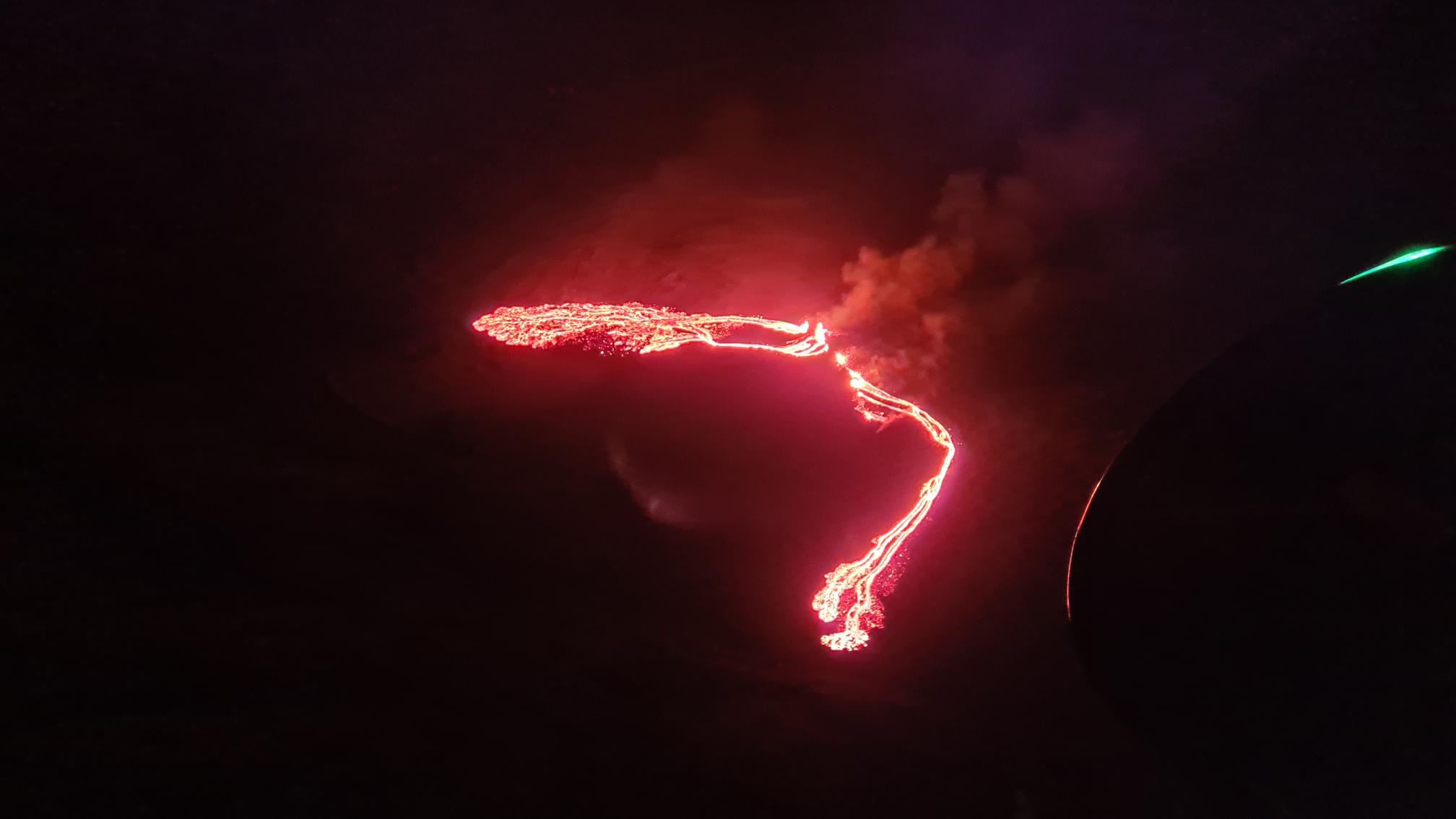
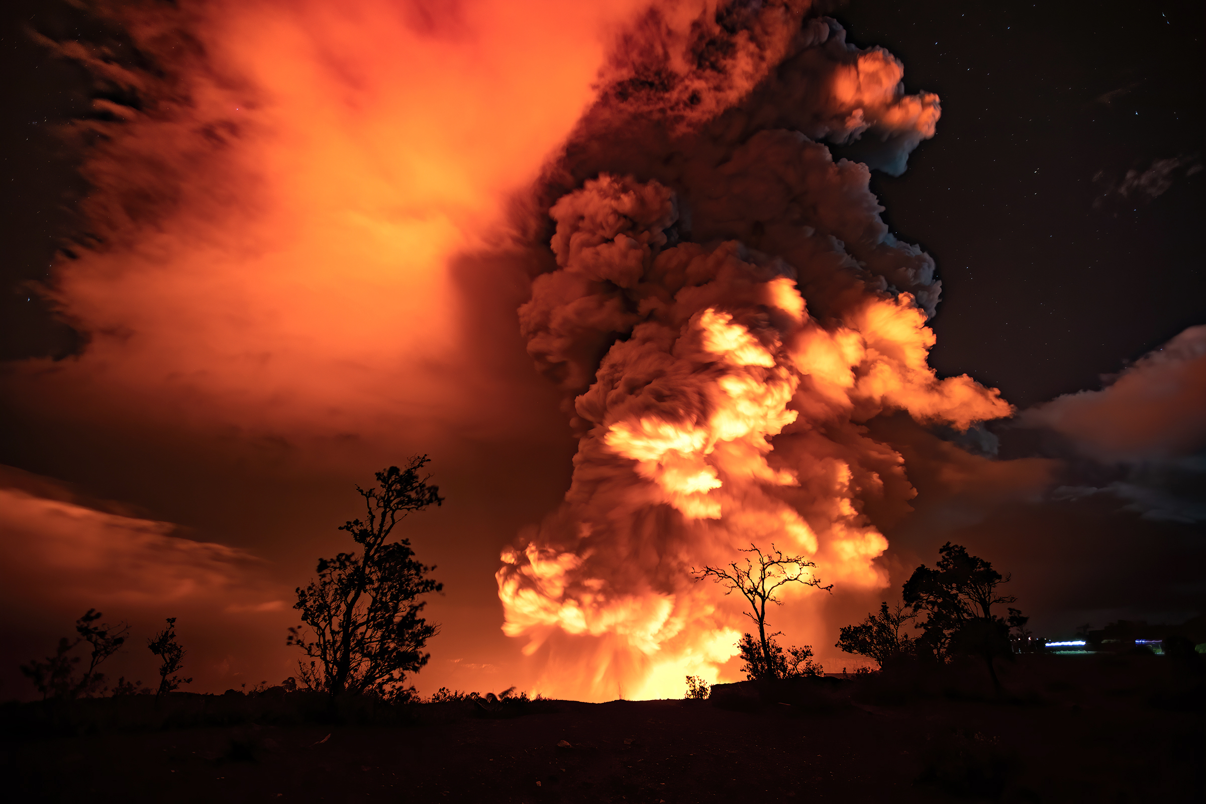
In March, Iceland gave birth to the world’s newest volcano in Suðurstrandarvegur: Fagradalsfjall. In March, this new volcano began an eruption, delighting tourists with views of lava ejecting from fissures while a fountain of lava glows at the new volcano’s summit. For now, the lava isn’t impacting nearby roads or population centers in Iceland’s capital district of Reykjavik. A month before the eruption began, thousands of earthquakes tipped-off scientists to the likelihood of a new eruption there, giving people a chance to prepare for the eruption.
Volcanoes will continue to erupt and some recently quiet volcanoes can also roar back to life just as quickly as others pause or end their eruptive cycles. Scientists urge caution and encourage people living near volcanic hazard areas to prepare for the possibility of new eruptions in the coming weeks and months.
The next volcano to erupt could be the world’s largest at Mauna Loa in Hawaii. In a recent news release, Hawaiian Volcano Observatory (HVO) scientists with USGS cautioned, “While an eruption of Mauna Loa is not imminent, now is the time to revisit personal eruption plans. Similar to preparing for hurricane season, having an eruption plan in advance helps during an emergency.”
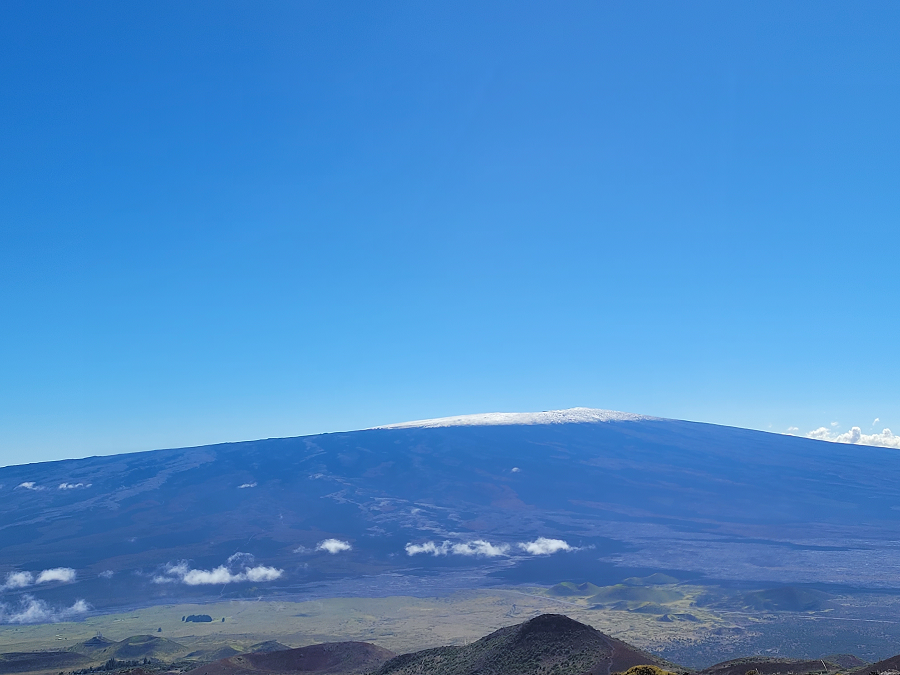
Mauna Loa is considered the largest active volcano on Earth, rising to 13,681 feet above sea level. Mauna Loa rises up from the ocean floor of the Central Pacific at a depth of about 3 miles. Because of the volcano’s significant mass, the ocean floor directly beneath Mauna Loa is depressed by another 5 miles. According to USGS, this places Mauna Loa’s summit about 56,000 feet above its base; the enormous volcano covers half of the island of Hawaii, also known simply as the “Big Island of Hawaii.”
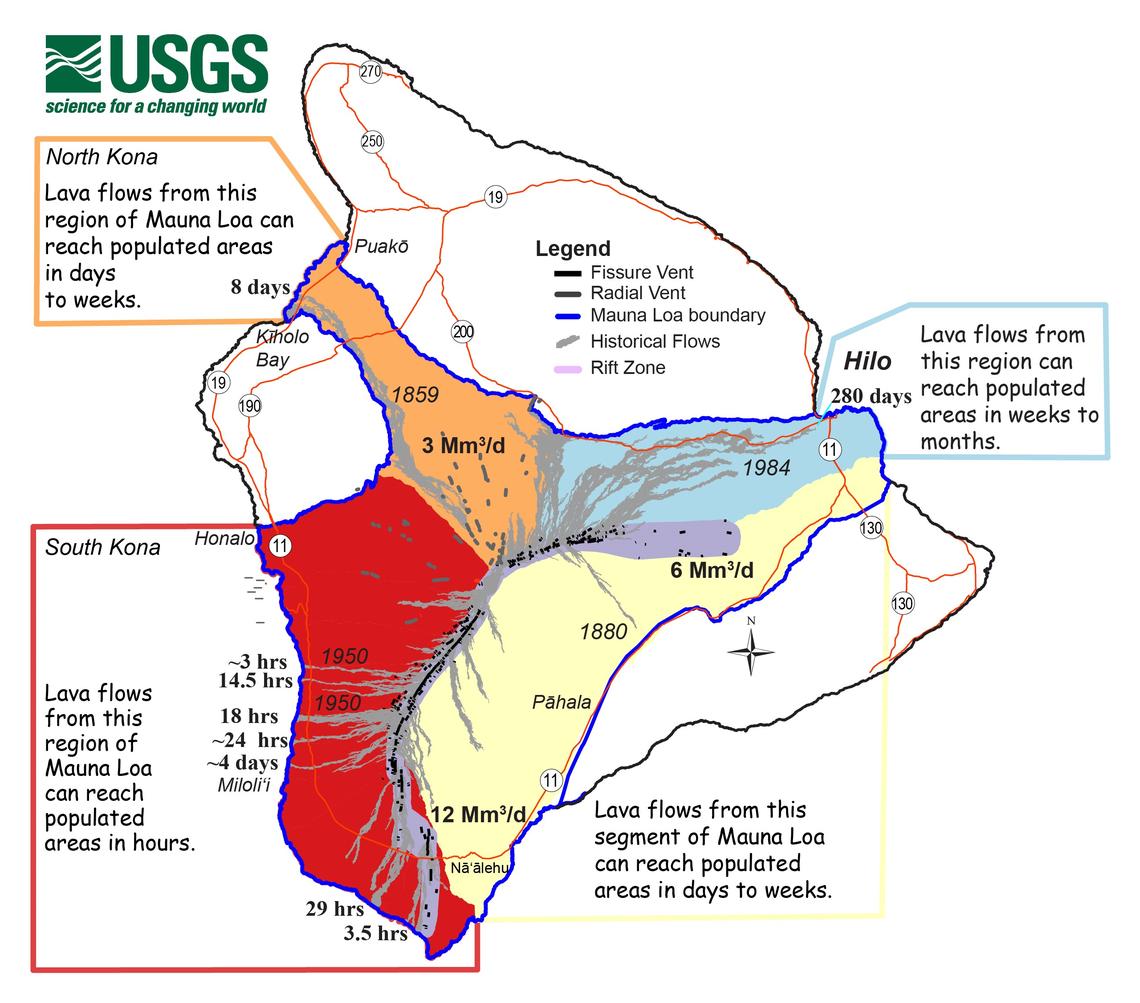
Mauna Loa eruptions tend to produce voluminous, fast-moving lava flows that can impact communities on the east and west sides of the Big Island from Kona to Hilo. Since the 1850s, Hilo in eastern Hawaii has been threatened by 7 Mauna Loa lava flows. On the south and west sides of the island, Mauna Loa lava flows have reached the coast there 8 times: in 1859, 1868, 1887, 1926, 1919, and three times in 1950.
According to USGS, while Mauna Loa is not erupting right now , rates of deformation and seismicity remain elevated above long-term background levels. GPS measurements continue to show slow, long-term summit inflation consistent with magma supply to the volcano’s shallow storage system. A slight increase in the rate of inflation that began in January continues.
Scientists aren’t sure if Mauna Loa will be the next volcano to erupt in the U.S.. Because the location of the next eruption is not yet known, scientists recommend that those potentially in harm’s way in Hawaii, Alaska, or the U.S. west such as Washington, Oregon, and California be aware of volcanic hazards and be prepared for possible problems that could come should an eruption occur there.
