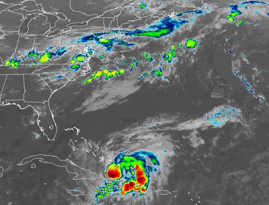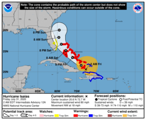
Hurricane Isaias continues to show signs of gaining strength, prompting authorities to issue additional Hurricane Warnings. Later on Friday, additional watches or warnings could be issued for the hurricane along the U.S. East Coast by the National Hurricane Center.
The government of the Bahamas has issued a Hurricane Warning for the central and southeastern Bahamas, which include the Acklins, Crooked Island, Long Cay, the Inaguas, Mayaguana, the Ragged Islands, Cat Island, the Exumas, Long Island, Rum Cay, and San Salvador. A Hurricane Warning is also in effect for the Northwestern Bahamas including Andros Island, New Providence, Eleuthera, Abacos Islands, Berry Islands, Grand Bahamas Island, and Bimini. A Tropical Storm Warning remains in effect for the entire southern and northern coastline of the Dominican Republic, the north coast of Haiti from Le Mole St Nicholas eastward to the northern border with the Dominican Republic, and the Turks and Caicos Islands. A Tropical Storm Watch remains in effect for the east coast of Florida from Ocean Reef to Sebastian Inlet as well as Lake Okeechobee.

A Hurricane Warning means that hurricane conditions are expected somewhere within the warning area. A warning is typically issued 36 hours before the anticipated first occurrence of tropical-storm-force winds, conditions that make outside preparations difficult or dangerous. Preparations to protect life and property should be rushed to completion. A Tropical Storm Warning means that tropical storm conditions are expected somewhere within the warning area within 36 hours. A Tropical Storm Watch means that tropical storm conditions are possible within the watch area, generally within 48 hours.
The National Hurricane Center in Miami, Florida says there are many key messages they wish to convey about Isaias for now. First, Isaias will produce heavy rains and potentially life-threatening flash flooding and mudslides across the Dominican Republic, northern Haiti, Turks and Caicos, and the Bahamas. Second, hurricane conditions and dangerous storm surge are expected in portions of the southeastern Bahamas overnight, central and northwestern Bahamas late Friday and Saturday, and Hurricane Warnings are in effect for these areas. Preparations to protect life and property should be rushed to completion. Third, Tropical storm conditions are possible along portions of the Florida east coast beginning Saturday, and a Tropical Storm Watch is in effect. While storm surge watches are not currently needed for this area, they may be required on Friday if the forecast track shifts closer to the coast. Heavy rains associated with Isaias may begin to affect South Florida and east-Central Florida beginning late Friday night, potentially resulting in isolated flash and urban flooding, especially in low-lying and poorly drained areas. Lastly, there is a risk of impacts from winds, heavy rainfall, and storm surge late this weekend from the northeastern Florida coast and spreading northward along the remainder of the U.S. east coast through early next week.
According to the National Hurricane Center, the details of the track and intensity forecast remain uncertain, and it is too soon to determine the magnitude and location of these potential impacts, but interests along the entire U.S. east coast should monitor the progress of Isaias and updates to the forecast.