• Skip to primary navigation
  • Skip to main content
  • Skip to primary sidebar

Weatherboy

Weatherboy Weather News, Maps, RADAR, Satellite, and Forecasts.

  • Local
  • Earth Science News
  • RADAR
  • Current Warnings
  • Satellite
  • Current Maps
  • Forecast Maps
  • Video

Warnings issued for Hawaii

by Weatherboy Team Meteorologist - August 7, 2018

Hurricane Hector approaches Hawaii. Image: NOAA


The Central Pacific Hurricane Center has upgraded the Tropical Storm Watch that was in effect for the Big Island of Hawaii to a Tropical Storm Warning. Hector is expected to pass south of Hawaii tomorrow with no direct impacts expected; however, rough surf, gusty winds, and some heavy rain showers are possible. Interests on Johnston Island should monitor the progress of Hector in the coming days.

A Tropical Storm Warning means that tropical storm conditions are expected somewhere within the warning area.

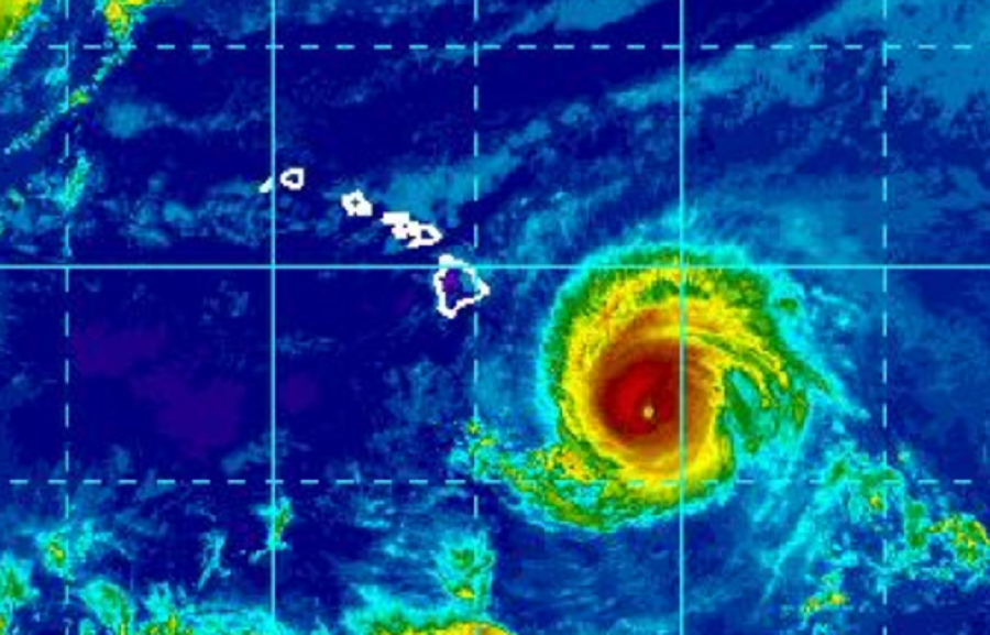
As of 5pm HT,  the center of Hurricane Hector was located near latitude 16.6 North, longitude 150.7 West. Hector is moving toward the west near 16 mph and this general motion is expected to continue through the next couple of days. On the forecast track, the center of Hector will pass 100 to 150 miles south of the Big Island during the day on Wednesday. Remember, the effects of a hurricane are far reaching and can extend well away from the center. Maximum sustained winds are near 130 mph, making it a Category 4 Hurricane on the Saffir-Simpson Hurricane Wind Scale. Some weakening is forecast during the next 48 hours.

Tropical Storm Warnings are now in effect for Hawaii's Big Island.  Image: CPHC
Tropical Storm Warnings are now in effect for Hawaii’s Big Island. Image: CPHC
Hurricane-force winds extend outward up to 40 miles  from the center and tropical-storm-force winds extend outward up to 115 miles. Because the storm is passing 100-150 miles south, it is possible none of these winds will reach Hawaii. However, people in Hawaii, especially in the southern portions of the island, should be prepared in case the storm shifts north. Any minor shift north could bring more severe conditions up over the Big Island of Hawaii.

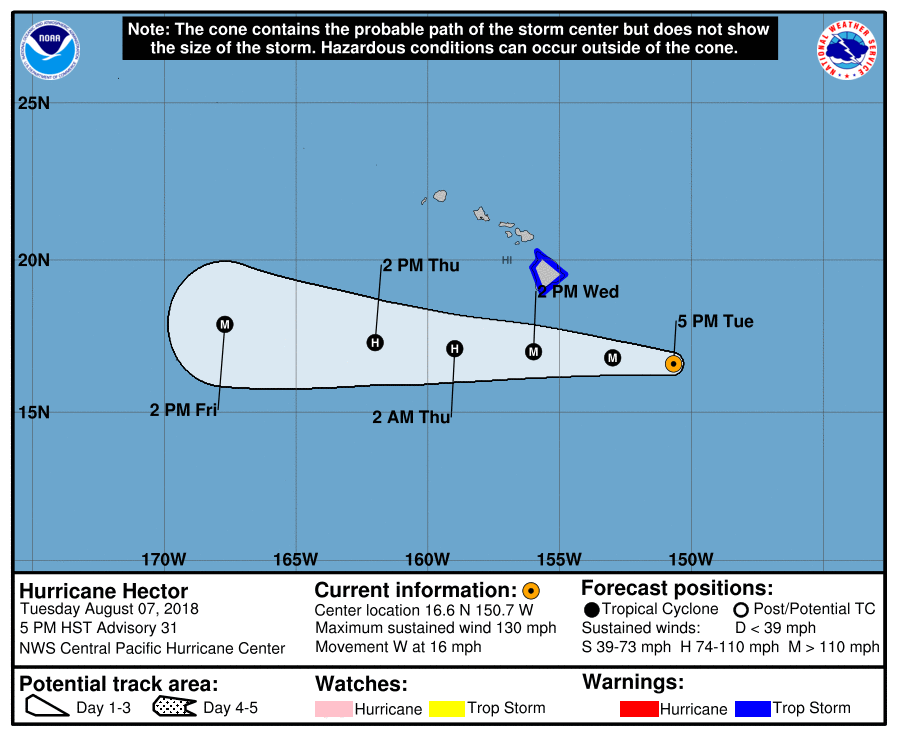
The estimated minimum central pressure is 952 mb (28.12 inches).


Swells generated by Hector are expected to reach southeast and east facing shores of the Big Island and eastern Maui late today, likely becoming large and dangerous by late tonight and Wednesday. Even experienced swimmers and surfers should stay out of dangerous ocean conditions.

The worst of the wind would impact Hawaii on Wednesday. The strongest winds are expected downslope from mountains, across elevated terrain, over headlands, and through gaps. Stronger winds and dry, down-slope conditions could create fire weather concerns, especially across the Saddle and south of the Kohala mountains in Western Hawaii.


Primary Sidebar

Sponsored Ad

Search

Latest News

  • Mega Tsunami that Wiped Out Dinosaurs Simulated by International Experts
  • Heavy Rain and Snow Helped, but Drought Persists in West
  • Today Marks 37th Anniversary of Space Shuttle Tragedy
  • While East Coast Snow Drought Continues, New Winter Storm Brings Heavy Snow to Hawaii
  • Weather Satellites and their SARSAT Technology Saved Hundreds of Lives in 2022
  • Snow Drought Persists in Philadelphia, New York City, New Jersey, & Surrounding Areas
  • Earthquakes Rattle Los Angeles Area
  • Rocket Lab Has Spectacular Launch from Mid Atlantic This Evening
About | Careers | Contact | Contests
Terms | Privacy | Ad Choices
Weatherboy is a (R) Registered Trademark of isarithm LLC, All Rights Reserved.
All content herein is Copyright by Isarithm LLC 1997-2022