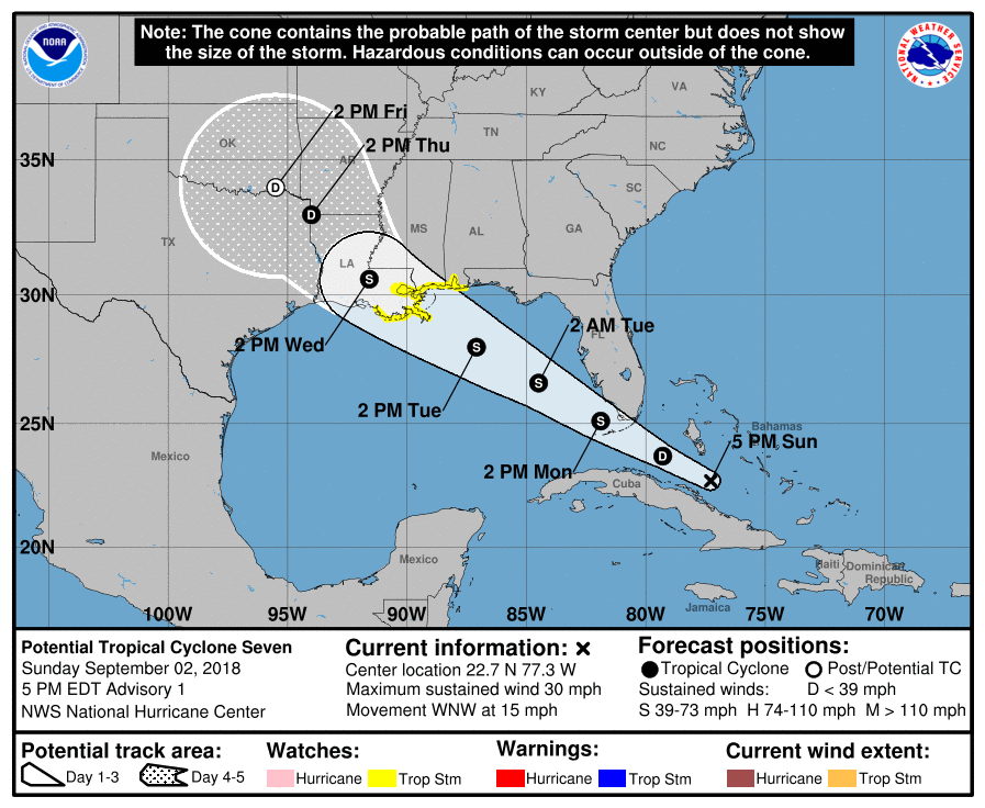
The National Hurricane Center has issued Tropical Storm Watches for portions of the central Gulf coast ahead of a potential tropical cyclone. As of 5pm ET, a disturbance was centered near latitude 22.7 North, longitude 77.3 West, and moving moving toward the west-northwest near 15 mph. This general motion is expected to continue through Wednesday, according to the National Hurricane Center (NHC.) On the forecast track, the disturbance will pass over the Florida Keys Monday afternoon, emerge over the southeastern Gulf of Mexico by Monday evening, and reach the central Gulf Coast by Tuesday night or Wednesday morning.
At this time, maximum sustained winds are near 30 mph with higher gusts. The NHC says gradual strengthening is forecast during the next 48 hours, and the disturbance is expected to become a tropical depression Monday morning and a tropical storm by Monday evening. When it is upgraded to a Tropical Storm, it will be named Gordon. The NHC is very confident this system will strengthen; they believe there’s a 90% chance of it doing so.
To alert people of the risk of the approaching tropical cyclone, a Tropical Storm Watch has been issued for portions of the central Gulf Coast from the Alabama-Florida border westward to east of Morgan City, Louisiana, including Lake Pontchartrain and Lake Maurepas.
Strong winds and very heavy rain are expected around this system in the coming days. Tropical storm conditions are possible within the watch area by Tuesday night and Wednesday. Tropical-storm-force wind gusts will be possible Monday afternoon and evening across portions of South Florida and the Florida Keys. The disturbance is expected to produce total rain accumulations of 2 to 4 inches over the central and northwestern Bahamas, the Florida Keys, and South Florida through early Tuesday. Isolated maximum amounts of 8 inches are possible over the southern Florida peninsula. This rainfall may cause flash flooding. The disturbance is expected to produce heavy rainfall along the central Gulf Coast of the United States by the middle of the week
