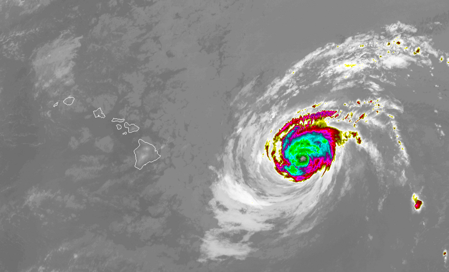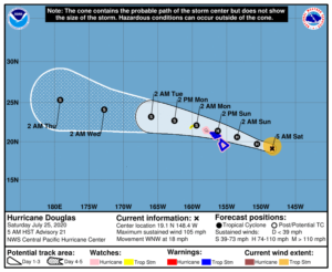
The Central Pacific Hurricane Center (CPHC) based in Honolulu, Hawaii has expanded watches to include all of the main islands of the chain and have now issued warnings for Hawaii (Big Island) and Maui county. Hurricane Douglas is expected to impact the state of Hawaii tomorrow as a hurricane, and extremely rare occurrence for the Aloha State. Often times, storms will weaken to Tropical Storm Status prior to arriving in the islands, but it is possible Douglas will hit the state as a hurricane soon.
While a Hurricane Watch remains in effect for Hawaii County and Maui County, including the islands of Maui, Lanai, Molokai, and Kahoolawe, a Tropical Storm Warning is now in effect there too. A Hurricane Watch remains in effect for Oahu; warnings could be issued for Oahu later today. A Tropical Storm Watch has been issued for Kauai County, including the islands of Kauai and Niihau. A Tropical Storm Warning means that tropical storm conditions are expected somewhere within the warning area within 36 hours. A Hurricane Watch means that hurricane conditions are possible within the watch area, in this case within the next 36 to 48 hours. A Tropical Storm Watch means that tropical storm conditions are possible within the watch area, in this case within the next 36 to 48 hours.
Beyond the main Hawaiian Islands, the CPHC cautions that interests elsewhere in the region, such as those around the Papahanaumokuakea Marine National Monument, should monitor the progress of this system.
As of the latest advisory from the CPHC, Hurricane Douglas’s top winds are near 105 mph with higher
gusts. While this reflects lower winds from yesterday, and additional gradual weakening is expected, Douglas is still forecast to be near hurricane strength when it nears the islands and could landfall over an island as a full-fledged hurricane. The estimated minimum central pressure is 975 mb or 28.80 inches.

For now, hurricane-force winds extend outward up to 25 miles from the center and tropical-storm-force winds extend outward up to 105 miles. CPHC Director Chris Brenchley tells us that the wind field could expand somewhat as it approaches the state.
While the official forecast cone from the CPHC shows the center of the storm moving just north of Hawaii and Maui islands, they warn that impacts could be felt outside of the cone throughout much of the state. Robert Ballard, Science & Operations Officer for the CPHC tells us, “a hurricane is not a point, it’s an area.” As such, severe winds, violent surf with storm surge, and heavy rains are possible through much of the state even though the cone graphic simply indicates where the center of the storm could be.
Some are letting their guard down in Hawaii because they’re not in the CPHC forecast cone. We asked CPHC’s Robert Ballard about this; he warns people that impacts from Hurricane #Douglas can be felt beyond it; all islands have potential impacts:#HIwx pic.twitter.com/7uL0TQwJl5
— the Weatherboy (@theWeatherboy) July 25, 2020
According to the CPHC, large swells generated by Douglas are expected to affect the Hawaiian Islands this weekend. These swells are likely to cause life-threatening surf and rip current conditions for the next couple of days. Even the most experienced swimmers and surfers should avoid the ocean this weekend. While the CPHC isn’t issuing Storm Surge advisories, they warn that a storm surge of 2-4 feet could be possible in areas as very tall, violent surf smashes the coastline of the islands.
While there’s no Storm Surge advisory up in Hawaii due to Hurricane #Douglas, that doesn’t mean there won’t be one. We asked @NWSHonolulu‘s Robert Ballard about possible storm surge in Hawaii around this storm:#HIwx pic.twitter.com/7hPkWHEBiS
— the Weatherboy (@theWeatherboy) July 25, 2020
Heavy rainfall associated with Douglas is expected to affect portions of the main Hawaiian Islands from late tonight through Monday. Total rain accumulations of 5-10″ are possible from Maui County westward to Kauai County, with the greatest amounts in elevated terrain. This rain may result in life-threatening flash flooding and land slides, as well as rapid water level rises on small streams. Douglas is expected to produce 2-5″ of rain over the northern half of the Big Island.
Specific impacts across the state will vary based on exact storm track and influence with the mountainous terrain of Hawaii. Haleakala on Maui rises to over 10,000 feet while the volcanic mountains of Mauna Kea and Mauna Loa rise to over 13,000 feet on Hawaii’s Big Island. These tall mountains will disrupt the flow around the storm, helping shelter some from clouds, rains, and winds, while making rain and wind worse for others. While the southwest corner of Maui and Hawaii islands have best odds of getting through this storm unscathed, it’s imperative everyone plan for the worst anyway. A simple shift by just a few miles could lead to a totally different local weather situation and how that pans out won’t be known until it actually happens or right before.
The terrain can also help create extreme winds well away from the core of the hurricane’s winds. As the flow of air circulates around and into the vacuum-like structure of the hurricane, downslope winds in Hawaii can create fast-moving, damaging gusts. Some downslope winds could also feature extremely low dewpoints, leading to fire weather conditions. While the exact track of Hurricane Douglas will determine where these types of winds can exist, the greatest threats now are near Lahaina on Maui and Waikoloa on Hawaii. People in these areas need to be alert for the wildfire threat and the possibility of any wind-fanned flames that could rapidly spread fire around a hurricane. In 2018’s Hurricane Lane, this became a problem on Maui where a wildfire forced the evacuation of a shelter holding hurricane evacuees.
CPHCs’ Tom Birchard says Hawaiian terrain effects can cause strong localized acceleration of wind through gaps & where winds blow downslope. “These acceleration areas will shift w/time as #Douglas passes near the islands.” We asked the Director of CPHC more about this: #HIwx pic.twitter.com/I8QGizmwBn
— the Weatherboy (@theWeatherboy) July 25, 2020
Hurricane Douglas is a relatively fast mover. Currently moving west north west at 18 mph, it is expected to slow down a bit as it approaches the State of Hawaii. While it will slow down, it shouldn’t linger as long as Lane did in 2018, which created an extended period of record-breaking heavy rainfall for portions of the state. By Monday afternoon, the storm should be moving away from Kauai Island and rough seas and winds will begin to relax from east to west across the state.
There are currently no other tropical cyclones in the Central and Eastern Pacific Hurricane Basins nor are any expected to form over the next 5 days. The Central Pacific Hurricane season runs now through the end of November. Earlier this year, CPHC meteorologists said the year would feature a near-normal or below-normal level of hurricanes and tropical storms in the basin; however, they warned it just takes one storm to create a disaster. Douglas could be that disaster.

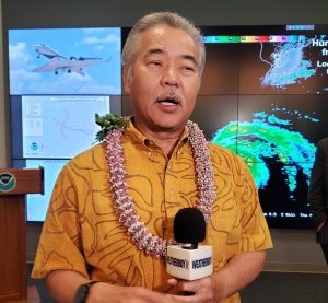
On Thursday, Hawaii Governor David Ige declared an Emergency Disaster Declaration. “Our top priority is always the safety, health and well-being of our residents and visitors. Please take immediate steps to protect your families, loved ones, employees and property. We ask everyone to closely follow emergency instructions as we prepare for Hurricane Douglas,” said the Governor.