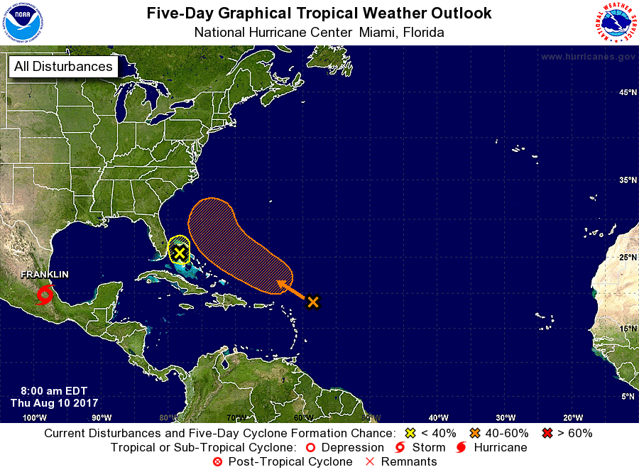
While Hurricane Franklin, the first hurricane of the 2017 Atlantic Hurricane Season, came ashore Mexico last night, eyes are back on the eastern Atlantic where new tropical disturbances may be forming. In their latest five day outlook, the National Hurricane Center (NHC) is tracking two systems east and south of the US Southeast coast.
The system that is closest poses the least amount of risk. A trough of low pressure over the Bahamas is producing disorganized showers and thunderstorms. Although development is not anticipated, this system could bring locally heavy rains to portions of the Bahamas and Florida during the next day or two. According to the NHC, odds of this system becoming a tropical cyclone are low; they say there is only a 10% chance of tropical cyclone formation at anytime over the next five days.
A system that has been tracked for the last week is of greater concern, although there’s still a medium chance at best of tropical cyclone formation there. Showers and thunderstorms associated with a trough of low pressure located about a couple of hundred miles east-northeast of the northern Leeward Islands have changed little overnight. Some slow development of this system is possible during the weekend while the system moves northwestward over the western Atlantic. Global forecast models that meteorologists use to aid in their weather forecasting, including the European ECMWF and the American GFS, have each shown this system blossoming into a robust tropical cyclone in recent days, but subsequent runs have quashed those predictions. While the NHC believes there’s a low chance of formation over the next 48 hours of only 20%, they describe the chance of formation over the next five days as “medium” at 40%.
Today, August 10, is typically the first day hurricanes form in an average season; yesterday’s Hurricane Franklin beat that average by a day. The peak of the season arrives within the next few weeks and there will likely be many more tropical cyclone threats along the US Gulf and East coasts as we head into September.
Experts believe this Atlantic Hurricane Season, which runs through to the end of November, will be a busy one. Dr. Phil Klotzbach and the experts at Colorado State University updated their seasonal outlook again on July 5, showing a much more active than normal season expected. The National Oceanic and Atmospheric Administration (NOAA) also released their own forecast which shows this hurricane season to be likely more active than others.
