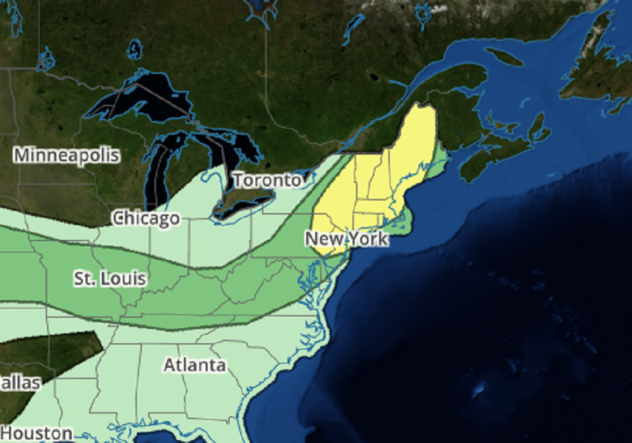
A severe weather event is likely to unfold across much of the northeastern U.S. tomorrow, threatening the region with severe thunderstorms that could produce damaging wind gusts, large hail, and isolated tornadoes. The best chance for severe thunderstorms on Wednesday include parts of the northern Mid Atlantic Coast states into New England Wednesday. Additional strong to severe storms are possible in a corridor from the central Plains into the lower Ohio Valley, and near the Rockies.
According to the National Weather Service’s Storm Prediction Center, a variety of meteorological ingredients are expected to come together to produce the severe weather. A larger-scale mid/upper troughing is forecast to progress inland of the British Columbia and Pacific Northwest coast, through the Canadian Rockies and northern U.S. intermountain region by late Wednesday night. As this occurs, sharp downstream ridging should shift eastward across interior Canada, while large scale troughing to the east develops across Ontario/Quebec and the Great Lakes region, toward the northern Atlantic coast.
Computer forecast models that meteorologists use to aid in their forecasting indicate the eastern troughing will include an embedded mid-level low, with at least a couple of significant perturbations migrating through the broader cyclonic flow. One of these is forecast to be in the process of digging into the upper Great Lakes region early Wednesday, before accelerating eastward and northeastward into and through Quebec by late Wednesday night and early Thursday morning. It appears that associated forcing for ascent will support significant surface cyclogenesis across Quebec, with the most rapid deepening to the northwest of the St. Lawrence Valley Wednesday night.
A front trailing from the developing cyclone is expected to advance through much of the Upper Midwest, mid Missouri Valley and northern Plains by early Wednesday, before continuing southeastward into/through New England, the Ohio and middle Mississippi Valleys and the central Plains by Thursday morning. The front will be preceded by the remnants of convective outflow from the large ongoing convective system which may still be evident across the central Appalachians and lower Ohio Valley early Wednesday.
Seasonably moist air along and ahead of pre-frontal surface troughing across parts of the Northeast, and the convective outflow/cold front extending westward across the central Appalachians into the Rockies, appears likely to contribute to
moderate to strong potential instability with daytime heating Wednesday. This is expected to provide support for areas of strong thunderstorm development, some of which will probably pose at least some risk for severe wind and hail.
It is possible that the associated surface cold front may become a focus for thunderstorm development, but this may be mostly over portions of southeastern Ontario and southwest Quebec prior to Wednesday evening. However, the primary convective potential seems likely in association with forcing for ascent accompanying a remnant convectively generated or enhanced perturbation, which is forecast to develop northeastward ahead of the primary troughing within the westerlies, from the lee of the lower Great Lakes region through New England by Wednesday evening.
An environment conducive to organized severe storm development across parts of eastern New York, Pennsylvania, and much of New Jersey through much of New England is expected. Potentially damaging wind gusts appear the primary hazard, but there may be at least some risk for a tornado or two, particularly across the Hudson/Champlain Valley vicinity into western New England Wednesday afternoon.