The combination of the intense surface low to the northeast over the Canadian Maritimes and a strong high pressure in the northern Plains to the Mississippi Valley is maintaining a tight pressure gradient across the Mid Atlantic. This setup is resulting in deep vertical mixing resulting in significant wind gusts. Fortunately, the air flow in the atmosphere will gradually weaken through Tuesday, however it will still be strong enough to keep breezy conditions.
According to the National Weather Service, there has been a notable downward trend in the winds this afternoon across much of the Mid Atlantic with gusts mostly below criteria. While it still remains gusty the overall risk of damaging winds has passed and therefore, they have
cancelled the Wind Advisory and High Wind Warnings that were in effect.
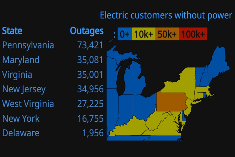
These were some of the highest gusts in the most impacted zones of Pennsylvania and New Jersey:
New Jersey
ATLANTIC COUNTY
Atlantic City 71 mph
Pleasantville 58 mph
Egg Harbor Township 47 mph
Hammonton 45 mph
BURLINGTON COUNTY
Moorestown 60 mph
Rancocas 60 mph
McGuire Air Force Base 55 mph
Lumberton 52 mph
Oswego Lake 52 mph
Silas Little 46 mp4
CAMDEN COUNTY
Pennsauken 50 mph
CAPE MAY COUNTY
Cape May 52 mph
Ocean City 51 mph
CUMBERLAND COUNTY
Fortescue 55 mph
Millville 54 mph
Upper Deerfield 51 mph
GLOUCESTER COUNTY
Kingsway Regional High School 56 mph
West Deptford 46 mph
HUNTERDON COUNTY
Pittstown 47 mph
Teetertown 45 mph
MERCER COUNTY
Trenton 60 mph
MIDDLESEX COUNTY
Perth Amboy 51 mph
MONMOUTH COUNTY
Sea Girt 63 mph
Keyport 59 mph
Belmar Farmdale 58 mph
Cream Ridge 51 mph
Sea Bright 51 mph
Oceanport 48 mph
Freehold 45 mph
MORRIS COUNTY
Randolph 47 mph
OCEAN COUNTY
Lakehurst Naval Air Station 66 mph
Island Beach State Park 65 mph
Mantoloking 42 mph
Berkeley Township 61 mph
Seaside Heights 61 mph
Beach Haven 57 mph
Toms River 56 mph
Harvey Cedars 51 mph
Surf City 50 mph
Lakewood 46 mph
Brick 45 mph
SALEM COUNTY
Mannington Township 45 mph
SUSSEX COUNTY
Hardyston Township 51 mph
WARREN COUNTY
Stewartsville 49 mph
PENNSYLVANIA
BERKS COUNTY
Reading 56 mph
Mount Penn 47 mph
Hopewell 46 mph
BUCKS COUNTY
Nockamixon 45 mph
Perkasie 45 mph
CHESTER COUNTY
White Clay Creek West Grove 62 mph
Marsh Creek 58 mph
West Chester 52 mph
Coatesville 49 mph
Chadds Ford 46 mph
Oxford 45 mph
DELAWARE COUNTY
Upper Chichester 46 mph
LEHIGH COUNTY
Macungie 49 mph
New Tripoli 46 mph
MONROE COUNTY
Mt. Pocono 61 mph
Wind Gap 46 mph
MONTGOMERY COUNTY
East Norriton 62 mph
Pottstown 56 mph
Fort Washington 52 mph
Willow Grove 52 mph
King Of Prussia 47 mph
PHILADELPHIA COUNTY
South Philadelphia 64 mph
Philadelphia International Airport 58 mph
Fair and calmer weather will return tomorrow into Wednesday ahead of the next area of low pressure. That next storm system is likely to bring heavy snow back to the east coast, although the heaviest of the snow should remain near the Delmarva peninsula and places west of there.
