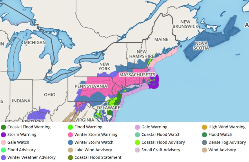
Data being crunched by computers and reviewed by meteorologists is suggesting a shift in the expected impact zone of a winter storm due to hit the northeast starting later tonight through tomorrow ahead of Valentine’s Day. Due to the forecast tweaks, the National Weather Service has expanded Winter Storm Watches and Warning. And due to those warnings, New York City has announced that their school buildings will be closed tomorrow, replaced with remote learning instead.
A few things have changed with this forecast update. Not only has the projected storm track shifted a little farther south, but with a stronger mid and upper-level low and a tighter mid and low-level temperature gradient, stronger dynamic forcing along with stronger cold air advection into the system looks to now result in a quicker changeover to snow, and heavier precipitation hanging back in the cold sector of the storm.
Due to these changes, the amount of precipitation that is expected to fall has increased near and just north of the I-95 corridor from central New Jersey north, while the amount of snow expected has increased between I-78 and I-80 north of there. While precipitation amounts are increasing on the south side of this winter storm, they are decreasing on the north side, with the most notable difference in western and central-northern Pennsylvania and Upstate New York; now, the heavier snowfall is forecast to be a bit south and east of there.
While liquid to snow ratios will be initially poor, the situation will change very quickly as the transfer to the coastal low occurs and the dynamic mid and upper-low passes to the south of the New York City metro area.
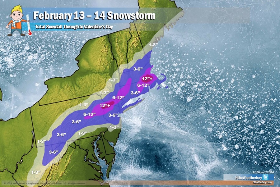
The heaviest snow will fall over portions of northeastern Pennsylvania, northern New Jersey, and southern Upstate New York where the three state borders are closest; here, 12-15″ of snow is expected to fall. The same is true for the area just west of Boston; while Boston will see close to a foot of snow, 12-15″ is possible in its western suburbs. Winter Storm Warnings have been issued by the National Weather Service in areas where the snowfall will be heaviest.
Less snow will fall in New York City where the National Weather Service has issued a Winter Storm Watch. There, 3-6″ of snow is expected to fall. Due to the snow forecast, New York City Mayor Eric Adams announced on X that New York City public schools will close tomorrow adding that students and teachers will conduct remote learning activities instead.
While a slushy inch or two may fall into central New Jersey, Philadelphia may now also see the same as rain changes to snow as the storm system departs.
Precipitation will spread into the northeast tonight. It will fall as plain snow north of New York City, but south of there, including much of eastern Pennsylvania, it will start as plain rain and change over. It appears the change-over will occur between 3 am to 8 am from I-78 to I-95. With 1-2″/hour snowfall rates possible along the I-80 corridor, and perhaps down into the I-78 corridor too, this could create big travel problems for the morning rush hour. Farther south and east, low-level temperatures will be more in the mid-30s with stronger forcing not co- located with the dendritic growth region. Combined with milder ground and pavement temperatures, snow still may struggle to accumulate along the I-95 corridor. The National Weather Service cautions, though, that given the rather dynamic situation with strong frontogenetic forcing, there may be a brief window for heavy snow even close to I-95 around the later part of the morning commute into the afternoon.
The snow will taper off from west-southwest to east-northeast quickly toward midday Tuesday for Pennsylvania, and away from New Jersey and the New York City metro area by later Tuesday afternoon. The snow in southeastern New England should clear the coast by Tuesday evening, giving people a chance to dig out under fair weather conditions by Valentine’s Day morning.
Snow isn’t the only hazard associated with this storm. The National Weather Service has also issued a Wind Advisory for the northern and central Jersey Shore, with gusts to 50 mph possible as the strong area of low pressure pulls away on Tuesday. Coastal flooding is also possible along Maryland, Delaware, New Jersey, Long Island, and southern New England coastlines.
