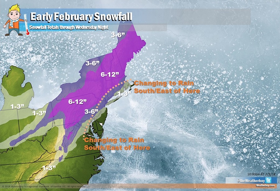
Another winter storm is expected to impact the Northeast during the middle of the week, dumping another round of moderate to heavy snow over interior New England. While precipitation could start out frozen or freezing as far south as Philadelphia, it is expected to turn over to plain rain as the system moves north and east into the northeast. It’ll be a little colder for a little longer in New York City, but even there, any snow or icy mix will change over to plain rain before the system exits.
On Tuesday, a cold front will be moving across the northeast during the midday hours. Ahead of this front, moisture will be increasing as a shortwave slides east. This shortwave is expected to generate some isolated and widely scattered snow showers across portions of northeast Pennsylvania, Upstate New York, and northern New Jersey. The rest of the Mid Atlantic region will only see an increase in cloud cover, with an isolated flurry possible here or there. Any snow shower activity will be limited with no significant accumulation expected.
More significant precipitation is expected later Tuesday night through to Wednesday night as the next system impacts the northeastern US. The system responsible for this weather event is an area of low pressure that will initially be organizing over the Southern Plain/Mid-South regions later tomorrow night. This low is expected to track to the northeast along a warm front, eventually passing through the northern Mid-Atlantic states Wednesday afternoon-evening.
This initial storm will follow the I-95 corridor on its trek north, which will bring snow north and west of it and rain south and east along the coastal plain. In between the snow and rain, an icy mix will set-up with rain becoming the dominant precipitation type in southeastern New England. This storm track and impact will be somewhat similar to what was seen on Sunday, although the airmass leading up to it should be colder than the weekend event. Because of that, precipitation will start as snow further south than it did on Sunday; places like Philadelphia and central New Jersey, along with points north and west of there, will see a snowy start. Near the coast, this snowy start will be short lived as warmer air aloft moves in. The changeover will be somewhat delayed as you travel north and west of I-95. The cold air will win over the warm air though north of New York’s capital district and north of the Massachusetts northern state line. In this colder zone, precipitation will stay all snow and could be heavy at times.
Due to the threat of significant winter precipitation, the National Weather Service has issued Winter Storm Watches for portions of the interior northeast. Conditions could become tricky there, with more than 4-7″ of snow expected with ice and sleet accumulations of 1/10″ or more closer to the transition zone with rain.
Precipitation is forecast to end quickly from northwest to southeast on Wednesday night as the low tracks northeastward into New England and the Canadian Maritimes. High pressure will build in behind the departing low, setting the stage for a fair but colder Thursday. The pressure gradient between the departing low and arriving high will also keep conditions quite breezy on Thursday. Winds in the northeast could gust 20-25mph which will help keep wind chill factors low on Thursday.