A winter storm is bringing heavy mountain snow and moderate lower elevation rains to portions of southern California, some of which continue to burn from wildfires, prompting the National Weather Service to issue Winter Storm Warnings and Flood Watches across the region. The precipitation is a mixed blessing; rains are needed to help put out fires and dampen areas susceptible for additional fires; however, heavy precipitation over burn scar areas could create mud and debris flows and perhaps even additional landslides.
According to the National Weather Service, a cold core upper low pressure system that is over Monterey and nearly stationary there is helping create this wet weather situation. The flow around this low has a good over water fetch and is picking up enough moisture to bring numerous showers to southern California. The upper low will move to the south in the afternoon and as the cold pool moves closer to the Los Angeles metro area, it will destabilize the atmosphere and a slight chance of thunderstorms will develop. The amount and intensity of the showers and storms will increase later this afternoon and especially overnight; the overnight hours look to be the most active with the most of rain of the storm.
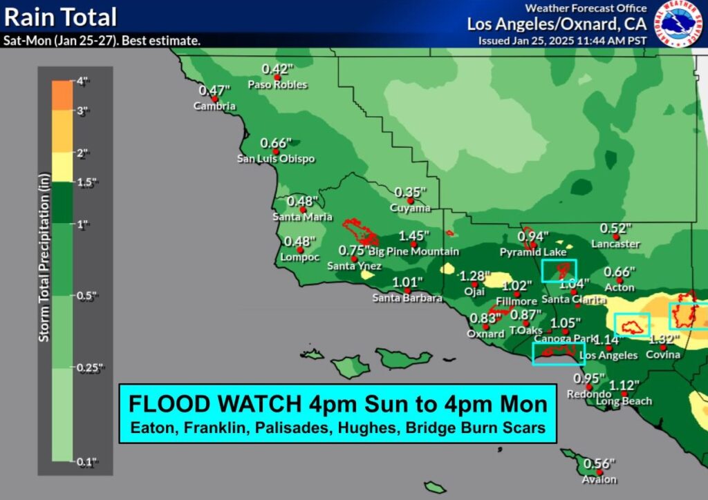
Los Angeles County is expected to receive the most rain and the most convection. The storm will slowly exit the area on Monday and the shower will taper off from west to east. The only exception will be the north slopes of the Los Angeles mountains where wrap around moisture will bring increased shower activity.
Rainfall rates through early afternoon will be under a quarter inch per hour. Quarter inch to a third of an inch per hour rates will become more common starting this afternoon. Isolated rates of .5-.75″/hour are possible after 4 pm as the showers become more intense. A Flood Watch for the Los Angeles County burn scars including Palisades, Franklin, Eaton, Bridge, Hughes continues.
The National Weather Service cautions that any thunderstorm that does form could produce brief heavy downpours and gusty winds. There is also a chance of small hail and waterspouts are possible over the coastal waters.
Snow levels will be between 3,500-4,500 feet for the majority of the storm system. 3-8″ of snow will be common across the mountains, with 6-14″ for the San Gabriels, with even greater amounts on the highest peaks. Snow levels will be low enough for snow along the Tejon Pass, with a couple inches of accumulation possible especially tonight into Monday. Convective snow showers may cause snow levels to locally drop to as low as 2,500 feet.
