A significant snowstorm is forecast to impact portions of the Mid Atlantic later tonight into tomorrow, prompting the National Weather Service to issue numerous advisories, including Winter Storm Warnings for heavy snow.
A wave of low pressure is developing behind today’s cold frontal passage; it appears this low will be more amplified than initially thought. This area of low pressure now appears to have the potential to amplify and acquire a negative tilt as it moves through the Southeast United States, spurring strong cyclogenesis near the Mid Atlantic coast. Extreme frontogenetic lift will cause a new precipitation shield to rapidly develop over portions of Virginia tonight, spreading precipitation north and east over Maryland, Delaware, southeastern Pennsylvania, and southern New Jersey later tonight into Monday.
As the precipitation shield blossoms, colder air will be rushing into the Mid Atlantic from the north. Temperatures will fall through the night, eventually near to below freezing across much of the central and northern Mid Atlantic. While some precipitation could start briefly as light rain, the continued infiltration of cold air and increasing precipitation intensity should support a quick changeover to snow.
The National Weather Service says several hours of moderate to potentially heavy snow are likely from early Monday morning into Monday afternoon, with snowfall rates of 1″/hour or greater at times possible. As the storm system pulls away into off-shore waters, snow will end during the late afternoon or early evening hours from southwest to northeast.
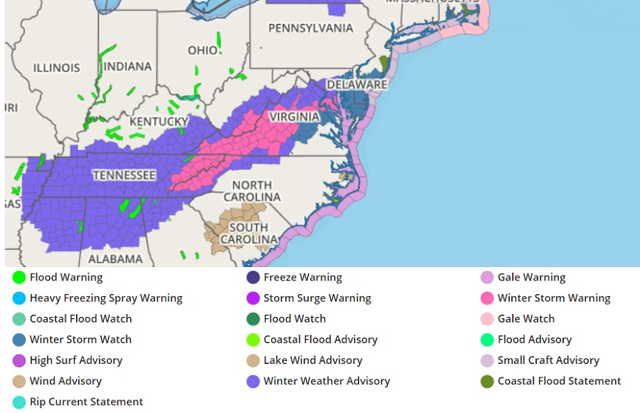
Due to the threat of heavy snow, the National Weather Service has issued a variety of advisories. Winter Storm Watches are now up across portions of southern New Jersey, central and southern Delaware, much of eastern Maryland, and portions of east-central Virginia. Winter Storm Warnings are now in effect across much of central Virginia, portions of eastern West Virginia, the mountains of western North Carolina, and eastern Tennessee. Winter Weather Advisories are also up across a broader area of the south which includes the rest of Tennessee, northern Mississippi, Alabama, and Georgia, portions of eastern Arkansas, southern Kentucky, central West Virginia, northern Virginia, and portions of central Maryland.
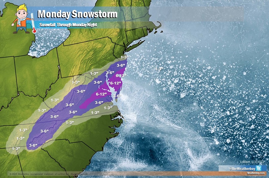
The snow will have a sharp cut-off line on the northern fringe of this storm, with the distance between no snow and significant snow very small. As such, a tiny shift in storm track may have significant implications to snowfall amounts. At this time, it appears snow will remain south of New York City with only flurries possible across central New Jersey and the Poconos of northeastern Pennsylvania. In portions of south-central New Jersey in southern Mercer, Middlesex, and Monmouth counties, a few inches of light snow are possible. A few inches of snow are also possible around Philadelphia, with greater amounts in South Philly than northern areas such as Chestnut Hill. Across extreme southern New Jersey, central and southern Delaware, and eastern Maryland and Virginia, the snow will be heavier, with amounts of 4-8″ possible. Isolated amounts of up to 10-12″ are possible where the heaviest snow band sets-up. However, recent mild ground temperatures and mild ocean temperatures will limit just how much snow actually sticks.
