• Skip to primary navigation
  • Skip to main content
  • Skip to primary sidebar

Weatherboy

Weatherboy Weather News, Maps, RADAR, Satellite, and Forecasts.

  • Local
  • Earth Science News
  • RADAR
  • Current Warnings
  • Satellite
  • Current Maps
  • Forecast Maps
  • Video

Winter Storm Watches Up

by Weatherboy Team Meteorologist - December 8, 2017

A wide area of 4-8" of snow will fall from the Appalachians into the Mid Atlantic and Northeast tonight into tomorrow. Map: Weatherboy.com
A wide area of 4-8″ of snow will fall from the Appalachians into the Mid Atlantic and Northeast tonight into tomorrow. Map: Weatherboy.com


The National Weather Service has expanded Winter Storm Watches for heavy snow as far north as New Jersey now as an intensifying coastal system appears to be bringing more wintry precipitation than earlier expected along parts of the eastern United States. Snow is expected from Texas to Maine, including locations in the deep south such as Louisiana, Mississippi, and Alabama; even northwest Florida could see a few flakes of snow.

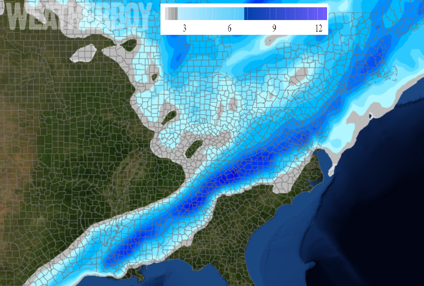
Snow falling in the south today will reach the Mid Atlantic by tomorrow; places like Atlantic City, NJ and Philadelphia, PA should see snow break out by daybreak on Saturday. Locations near and south and east of the I[95 corridor should see the most snow, with 1-3″ north and west of this region, and 3-6″ south and east to the Mid Atlantic coast. Some locations could see 5-9″ of snow where mesoscale banding occurs in isolated locations.


Winter Storm Watches and Warnings and Winter Weather Advisories have been posted in the eastern United States for the ongoing winter storm threat.   Map: weatherboy.com
Winter Storm Watches and Warnings and Winter Weather Advisories have been posted in the eastern United States for the ongoing winter storm threat. Map: weatherboy.com

At the immediate coast of Delaware, New Jersey, Long Island, and southeastern Massachussettes, there could be some mixing with non-snow precipitation. This may keep snowfall amounts a touch lower there than a bit inland. As an example, Atlantic City Airport may see a bit more snow than the Atlantic City boardwalk.

Winter Storm Watches have been posted for areas expected to receive the heaviest snow while areas north and west, where less snow is expected, are under Winter Weather Advisories.


This will be a heavy, wet snowfall. Because of the weight of the snow, there is a risk of power outages due to downed power lines and branches on those wires in swaths of heavier snow.

The snow will wrap up from southwest to northeast later Saturday, with fair high pressure arriving on Sunday and Monday. Old Man Winter isn’t done yet; another system could bring another round of accumulating snow to the Mid Atlantic and Northeast on Tuesday into Wednesday.

Primary Sidebar

Sponsored Ad

Search

Latest News

  • Halloween Earthquake Rattles Alabama
  • Hurricane Melissa Moves Away from Bermuda; Expected to Become Extratropical Today
  • Potent Storm to Impact New Jersey, Pennsylvania, Delaware, and New York
  • Ongoing Strong Caribbean Earthquakes Serve as Reminder to East Coast Tsunami Threat
  • MELISSA MAKES LANDFALL AS ONE OF STRONGEST ATLANTIC HURRICANES EVER
  • Apocalyptic Hurricane Melissa with 215 mph Wind Gusts & 4 Feet of Rain to Smash Into Jamaica
  • No U.S. East Coast / Caribbean Tsunami Expected from Strong Earthquakes
  • Major Hurricane Melissa to Bring Catastrophe to Jamaica with 195 mph Wind Gusts, 3 Feet+ Rain
About | Careers | Contact | Contests
Terms | Privacy | Ad Choices
Weatherboy is a (R) Registered Trademark of isarithm LLC, All Rights Reserved.
All content herein is Copyright by Isarithm LLC 1997-2022