Old Man Winter will be making his presence known in the northeast this week, with winter weather likely from Michigan to New Jersey to Maine on Tuesday into Wednesday, with a more substantial winter storm likely on Friday into Saturday.
High pressure will move offshore tonight, allowing a clipper type weather system to impact the northeast starting Tuesday with a warm front lifting
north. A cold front will push offshore Tuesday night, followed
by weak high pressure building on Wednesday.
The warm front will help set-off a period of light snow and/or light rain across portions of central and southern Pennsylvania and New Jersey; north of there, plain light snow will fall through Tuesday afternoon. By Tuesday night into Wednesday, the precipitation shield will pivot up into southern and central New England, with more snow expected there as precipitation stops in Pennsylvania and New Jersey and places south.
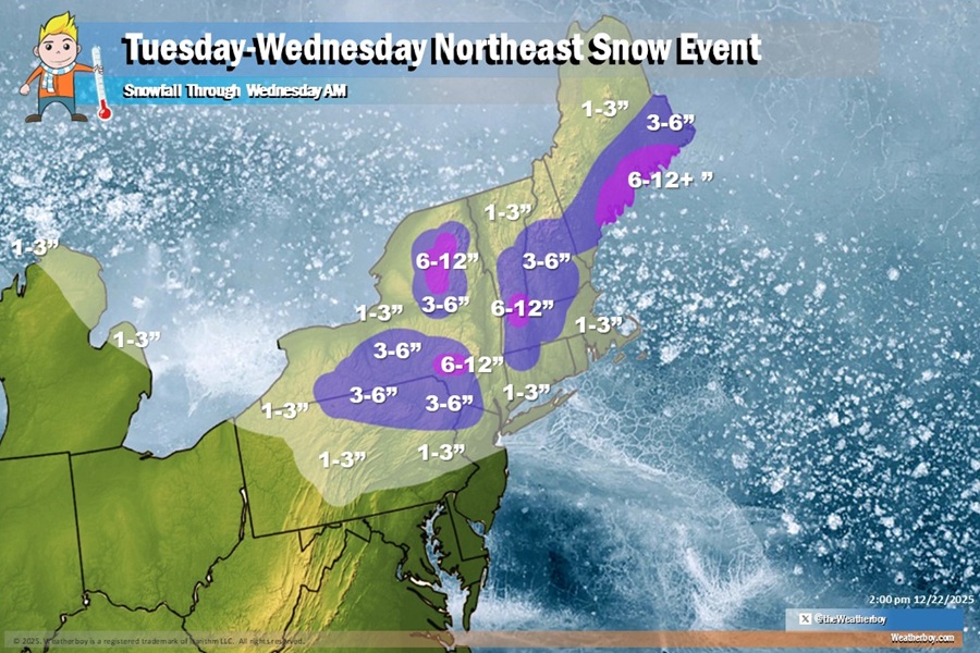
The weather system will bring enhanced heavier snowfall to portions of coastal Maine. There, 6-12″ of snow is possible. There will be other pockets of 3-6″ of snow over the higher terrain of northeastern Pennsylvania and adjacent places in Upstate New York, and interior southern New England. The higher terrain of New York, Vermont, and Massachussetts may also see more than 6″ of snow, although such heavier amounts will be very isolated. To the south, 1-3″ is possible over central Pennsylvania and the northern half of New Jersey, but little to no snow is expected south of I-195 and south and east of the New Jersey Turnpike. In New Jersey, much of the accumulating snow will remain north of I-78.
Another weak clipper system is possible on Christmas Day which could bring light rain to portions of Virginia and the south-central Mid Atlantic then. More importantly, this weather system will help bring colder air down into much of the northeast behind it, setting the stage for a potential larger storm on Friday.
On Friday it appears a more robust snowstorm could impact the northeast, with a plowable snowfall possible for places like the I-95 corridor through Philadelphia, New York City, and Boston.
