It’s time for our annual Winter Weather Outlook! Each year for the last three, we’ve released a temperature and precipitation outlook for the continental United States. Based on the positive results of the 2014-2015 and 2015-2016 forecasts, we are pleased to provide you our top-line thoughts on the 2016-2017 season. Our outlooks sum-up expected conditions for the period from December 1 through March 31; it is important to stress this is a sum of temperatures and precipitation over that entire period. Some places may see a very mild December followed by a brutally cold January, February, and March; those areas would net-out as “below normal.” There may be a snow drought of sorts for some areas in December and January, followed by incredible snowstorm after incredible snowstorm in February and March which pay push the net to “much above normal.” As such, it is important to read into this forecast and review the maps as a seasonal overview and not as a week by week or month-by-month forecast of expected conditions.
In developing these extended outlooks, there are numerous variables we look to for help in formulating a forecast for the future. There is no one factor or ingredient that drives the weather in a linear fashion. If there were, it would be much easier to make an accurate forecast by simply looking at a series of “If/Then” statements.

What are the ingredients we look at? For starters, we explore the current snow and ice cover over the northern hemisphere which helps keep an ample supply of cold air on the ready for intrustion to the US. (As of the last week of October, snowcover over Canada and Siberia are running at above-normal levels.) While you’re hearing a lot about last year’s strong El Nino in the Pacific fading away, the water temperatures there aren’t definitive of how conditions will play out in the United States. While El Nino certainty impacted the pattern and precipitation areas across the US last winter, it wasn’t the sole driving force in the overall pattern and the lack of El Nino this winter isn’t a sign of an absolute pattern or force either. Beyond warming/cooling of the Pacific through El Nino and La Nina, we also analyze sea surface temperatures elsewhere, including the Gulf Stream just east of the US east coast and water temperatures near and south of Greenland. We also look at oceanic and atmospheric steering currents that help buckle the jet stream, create ridges or troughs, and/or create blocks that create meteorological “traffic jams” of sorts which set the stage for severe wintry weather events. More technical and specific, we look at the Arctic Oscillation (AO), North Atlantic Oscillation (NAO), Eastern Pacific Oscillation (EPO), and Pacific Decadal Oscillation (PDO). Complicated, relatively recently discovered cycles are also studied, including the Quasi-Biennial Oscillation (QBO) in which upper level pressure and wind regimes influence conditions at the surface, especially within the Northern Hemisphere where we reside. We also examine other phenomena within our atmosphere, such as matter/gas ejected from volcanoes, and examine potential impacts from outside of our atmosphere: space weather and overall solar activity could impact weather conditions over a season. No one element, phenomena or cycle is responsible for the winter; instead, it’s a collection of many ingredients that come together to produce the temperatures and precipitation you’d see over the season.
Because of all of these factors, this is what we expect:
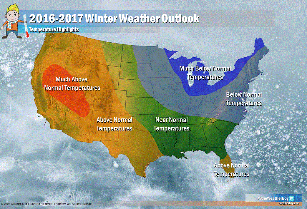
After a slow start to wintry weather, we expect the northeastern quarter of the country to cool down to below-normal levels while the western third of the country heats up. This will be a gradual transition that’ll especially take root in January, where we expect the most below-normal temperatures in the east and the most above-normal temperatures to persist in the west. Within these areas, we expect temperatures to be far from normal. Around the Great Lakes and northern New England, we expect temperatures to be extremely cold this winter, with much below normal temperatures forecast there. Conditions there will rival what we saw during the 2014-2015 winter where brutal cold temperatures compliments of the Polar region descended down on the northeast. While we do expect below normal temperatures as far south as southern North Carolina, we believe temperatures from Raleigh to New York City won’t be as bad as they were in the 2014-2015 winter. On the flipside, the west will see another season with above-normal temperatures, with portions of Nevada and Utah seeing temperatures much above normal.
As we saw last year with the seasonal forecast then, central and southern Florida will also see above normal temperatures.
Elsewhere, in the upper Midwest from eastern Montana to western North Dakota and south and east towards the lower Mississippi River Valley, and then east from there across the southeastern United States (southern half of Florida excluded), we expect near normal temperatures. This means we expect seasonal conditions, which on average, will net-out to typical wintertime conditions. This doesn’t rule out an occasional Arctic outbreak or mild spell in this region, but it does rule-out a full-season-lasting warm/cold spell here.

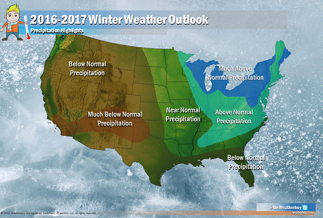
Along with the cold we expect plenty of precipitation in the a large part of the eastern United States, the exception being the southeast …and especially Florida and the Gulf Coast where dry conditions are forecast. Much above normal precipitation in the form of snow is expected over the Great Lakes region; we believe Great Lakes will be slow to freeze over this winter, setting the stage for many large Lake Effect Snowstorms. These storms will help keep areas susceptible to lake effect in above-normal precipitation bands. We also believe the storm track will be a busy one over the Mid Atlantic and northern southeast (northeastern Mississippi, northern Alabama, northern Georgia, and northern South Carolina.) As such, precipitation there should be at above-normal levels this upcoming winter season. For areas along the coastal plain, this will translate to more rain than usual; further inland, in places like the hilly terrain of western Maryland, Virginia, and West Virginia, this could translate into wintry, icy mixes. Further north, in places like New Jersey, Pennsylvania, New York, Connecticut, Delaware, Rhode Island, and Massachusetts, this could translate into a season with plenty of snow. We believe conditions just north and west of the fall line in northern Virginia, central Maryland, eastern Pennsylvania, and upstate New York may see especially high amounts of snow; the same is true along the eastern and coastal portions of Maine. Based on the weather pattern we expect to set-up this winter, there will also be many nail-biting close-calls, especially along the I-95 corridor; the rain/snow line will be close, although Philadelphia and New York and places north should take advantage of below-normal temperatures to produce more snow than rain; further south, the below normal readings may not always coincide with the available precipitation, leading to more cold rainy days than snowy ones in places like Washington, Baltimore and places south.

Southeastern New England will see above normal precipitation; however, unless a series of coastal storms blow-up along the coast, we don’t believe an end to the long-term drought conditions there will arrive over the winter. If this pattern spills out into the spring, there could be some hope.
While the east will benefit from an abundance of precipitation, the west will suffer from a lack of it. Based on the types of patterns we expect to set-up for the season, we believe southern California, northern New Mexico, northern Arizona, and southern Colorado will see much below normal precipitation amounts overall for the winter. This area of below-normal precipitation stretches south to the Texas Gulf coast and heads east into the remaining Gulf Coast region and all of Florida. There is a bright spot in our western precipitation forecast, and that is the Pacific Northwest. There, we expect northwest Oregon and western Washington to see near normal precipitation amounts over the December-March period.
Near-normal precipitation is also forecast for much of the Mississippi River Valley and areas of the midwest just west of there; this could be good news for a river system that has seen considerable, devastating springtime floods in recent years.


While we’ll need to wait to see just how accurate this winter outlook is, there are many certainties arriving in the coming weeks and months. First is the arrival of the season itself; Winter, defined by the Earth’s orbit around the sun, begins on the Equinox and Solstice which falls on December 21 this year. However, climatologists and meteorologists consider the start of “Meteorological Winter” to be December 1. And while it’s the season known for cold temperatures and snow, the Earth is actually closest to the Sun in the Winter. On January 4, the Earth will reach perihelion (peri meaning “near” and helion meaning “sun”) and the earth is 3.1 million miles closer to the sun than at aphelion (on July 3 when the earth is furthest from the sun). Earth’s distance from the sun is not what causes the seasons (it is the The Equinox and Solstice) but it does affect the length of them. Around perihelion the earth is moving around 2,240 miles per hour faster than at aphelion which results in winter being 5 days shorter than summer. The word “winter” comes from the Germanic wintar which in turn is derived from the root wed meaning ‘wet’ or water’, and so signifying a wet season. In Anglo-Saxon cultures, years were counted by the winters, so a person could be said to be “2 winters old”.