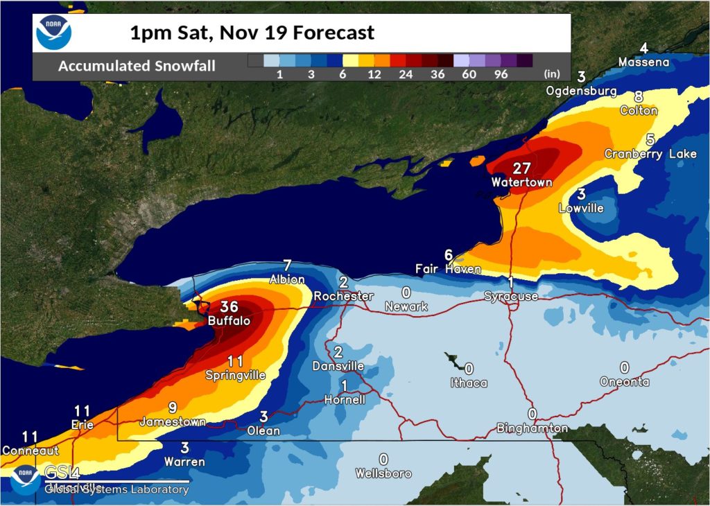
Old Man Winter is making an early appearance across the northeast; 3 or more feet of snow is possible in New York through Saturday as Lake Effect snow bands set-up off of Lakes Ontario and Erie; some models are also suggesting that another widespread snow event is possible later next week, with snow possible into the I-95 corridor and the major cities along it in the Mid Atlantic and New England areas.
The National Weather Service has issued Lake Effect Snow Warnings for portions of New York where heavy lake effect snow expected. Total snow accumulations of 1-3 feet are likely in the most persistent lake snow zones; winds gusting as high as 35 mph will produce patchy blowing snow which could reduce visibility and make travel treacherous at times.
A storm system exiting the northeast today is setting the stage for this extreme Lake Effect event. The storm that moved through the northeast over the last 24 hours brought snow accumulations as far south as Sussex County, New Jersey, with light accumulations measured throughout interior New England. As an area of low pressure exits across the St Lawrence Valley today, colder air will pour across Upstate New York with significant lake snows blossoming east of both lakes. This will be the start of a prolonged lake effect snow event which will likely include paralyzing snowfall for the Buffalo and Watertown areas late this week through the weekend.
For next week, computer forecast models are offering very different forecast solutions for the Thanksgiving holiday travel period, one of the busiest travel times of the year. The European ECMWF forecast model suggests a storm system will take shape over the Mid West and slide into the Great Lakes, bringing more wind-whipped lake effect snows there; if that forecast were to verify, conditions would be mild and perhaps wet along the coast, with colder air kept in Canada. However, the American GFS forecast model has a very different outcome, suggesting that a potent low pressure system will develop on the northeast coast, setting the stage for accumulating snowfall even into the I-95 corridor from Philadelphia north.
The GFS and ECMWF couldn’t be farther apart with their solutions for the post-Thanksgiving storm if they tried. European model sends a low to the Great Lakes before Thanksgiving while this American model produces a potent coastal storm in the northeast. pic.twitter.com/FQuQLeSWhj
— the Weatherboy (@theWeatherboy) November 16, 2022
It is too soon to know which extended range forecast model is right for next week. It’s possible or or neither are right about their solution; as more data is ingested and reviewed, the forecasts will be refined and made more accurate over time.
For now, residents under Lake Effect Snow Warnings and Winter Storm Watches and Warnings should be prepared for a potentially crippling storm that may take several days to dig out from.