
A storm system will likely bring 6-12″ of snow to portions of the southern Mid Atlantic on Thursday with New England entirely escaping the threat of a coastal storm. With cold air rushing south into the United States from Canada and the storm system unable to connect to energy over the Great Lakes, it will slide east out to sea, unable to come up the east coast to bring places like Philadelphia and New York City and all points north and east into New England any measurable snow.
While snow flurries are possible for places like Philadelphia and New York City, there probably won’t be much accumulating snow north of southern Delaware, southeastern Maryland, and central eastern Virginia.
But south of there, heavy snow is expected, with 3-6″ amounts likely across southeast Virginia and eastern North Carolina, with bands of 3-6″ also possible across portions of Alabama and Mississippi, Tennessee and Kentucky, and the higher terrain of western North Carolina and southern West Virginia.
More than 6″ is possible across coastal southeastern Virginia and northeastern North Carolina; the Outer Banks of North Carolina could see a foot of snow or more, making this the heaviest snowstorm of the year for there.
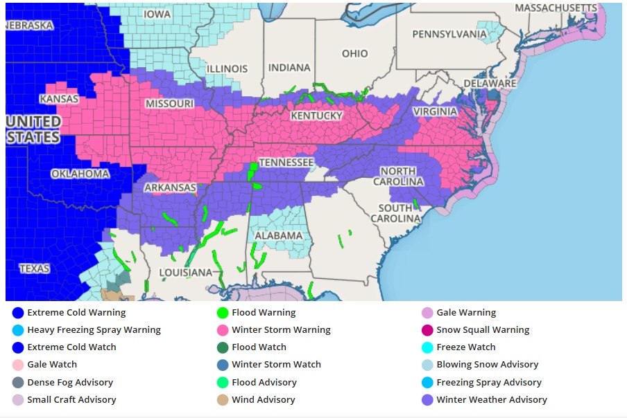
Responsible for this latest snowstorm is a large pool of Arctic air which continues to advance farther south into the mid-section of the country. In addition to the cold, snowfall is ongoing across the Plains and will spread eastward through the day for the Tennessee and Ohio Valleys. A swath of sleet/freezing rain can also be expected across the southern portion of these states from this afternoon into tonight. This will result in difficult travel conditions, with moderate to major impacts from a combination of snow and ice. Meanwhile, accumulating snowfall will continue to spread eastward across the southern Appalachians and Mid-Atlantic on Wednesday into Thursday. On the southern end of the snowfall in North Carolina, there is a higher chance for locally significant ice
accumulations that could result in dangerous travel conditions. Meanwhile,
lake-effect snow will once again impact the Snow Belt region downwind from
the Great Lakes, with small areas of heavy snow expected south and east of Lakes Superior and Ontario.
