A massive storm is forecast to bring significant, widespread impacts to much of the eastern U.S. in the coming days. According to the National Weather Service’s Weather Prediction Center, more than 60 trillion gallons of rain water is due to fall out of the sky from this impressive winter storm, including over areas that saw heavy snow this weekend. The result will be a widespread flood threat in portions of the Northeast and Mid Atlantic. Beyond the heavy rain, there is also the threat of severe thunderstorms and destructive wind gusts as this strong storm system heads east.
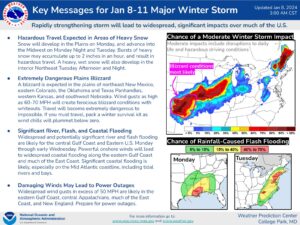
According to the National Weather Service, a deep and dynamic mid-latitude cyclone will organize over the Central and Southern Plains this morning. Snow will develop in the Plains today and advance into the Midwest tonight and Tuesday. Bursts of heavy snow may accumulate up to 2″/hour and result in hazardous travel. A heavy, wet snow will also develop in the interior Northeast Tuesday afternoon and night. A blizzard is expected in the Plains of northeast New Mexico, eastern Colorado, the Oklahoma and Texas Panhandles, western Kansas and southwest Nebraska. Wind gusts as high as 60-70 mph will create ferocious blizzard conditions with whiteouts. Travel will become extremely dangerous to impossible in this region.
Beyond snow, there will be severe storms. Severe thunderstorms capable of producing strong wind gusts and tornadoes are expected from southeast Texas across the central Gulf Coast this afternoon into early Tuesday morning. This Enhanced Risk of Severe Thunderstorms shifts into parts of southeastern Alabama, northern Florida and parts of the Carolina Piedmont/Coastal Plain on Tuesday. Very strong and damaging winds as well as a few tornadoes will be the main threats.
Widespread and potentially significant river and flash flooding are likely for the central Gulf Coast and Eastern U.S. through early Wednesday.
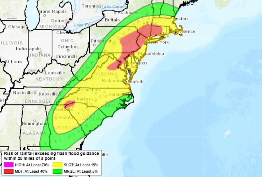
In addition to fresh water flooding from heavy rain, there will also be coastal issues to deal with too. Powerful onshore winds will lead to widespread coastal flooding along the eastern Gulf Coast and much of the East Coast. Significant coastal flooding is likely, especially on the Mid-Atlantic coastline, including tidal rivers and bays. There’s a Moderate Risk of Excessive Rainfall leading to Flash Flooding over parts of southeast Louisiana, southern Mississippi and southwestern Alabama today where several inches of rainfall may accumulate. The Moderate Risk of Excessive Rainfall shifts into the Mid-Atlantic on Tuesday between northern Virginia, up the I-95 corridor and into western Massachusetts, where existing snowpack from the recent snowstorm may cause additional runoff concerns.
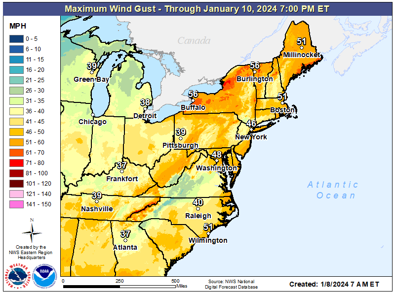
Widespread wind gusts in excess of 50 mph are likely in the eastern Gulf Coast, Central Appalachians, much of the East Coast and New England. Prepare for power outages.
