The National Hurricane Center has just issued an updated Tropical Outlook for this afternoon, saying there is now a 90% chance that a tropical cyclone will form off the Mid Atlantic coast later today or tonight. If this system becomes a named storm, it would be called “Fay” and would break records in the Atlantic basin for the earliest “F” storm on record. In 2005, Tropical Storm Franklin formed on July 22; if Fay were to form by tonight, that record would be broken by 13 days. In a typical hurricane season, the “F” or sixth storm of the year, would typically form by September. With the the ocean water anomalously warm off the Mid Atlantic coast, odds favor early season tropical development here.
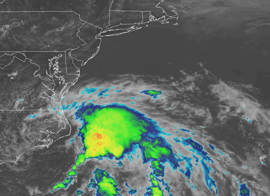
Shower and thunderstorm activity associated with a low pressure area located near the Outer Banks of North Carolina has continued to increase. According to the National Hurricane Center, recent satellite and radar imagery, along with surface observations and data from an Air Force Reserve reconnaissance aircraft that is just beginning to investigate the system, suggest that a new center of circulation could be forming east of Cape Hatteras. In a Tropical Outlook released at 2pm ET, the National Hurricane Center says, “If these development trends continue, this system is likely to become a tropical depression or storm later today or tonight.”
Where this system goes next remains in question. The low is expected to move north-northeastward along the mid Atlantic coast tonight through Friday night. Computer forecast guidance is split on just how strong it’ll become and just where exactly it’ll go; guidance from North American computers suggest Delaware and New Jersey could see landfall, while European guidance suggests a somewhat more east jog from there, bringing landfall to Long Island or southern New England. Either way, rough surf, heavy rain, and strong winds will batter the coast tomorrow into the first half of the weekend in the northeast.
Just days ago, tropical meteorology experts at CSU revised their seasonal forecast upward, calling for an above-normal hurricane season in the Atlantic Basin. Hurricane season in the Atlantic runs now through November 30, 2020.
