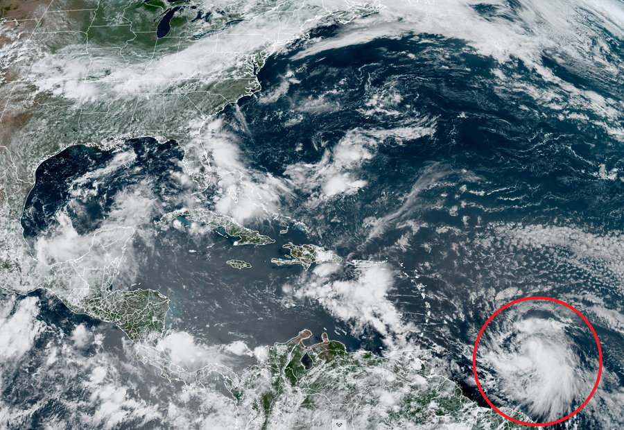
Tropical Storm Elsa is gaining strength and speed and could eventually threaten Florida and the U.S. East Coast over time. While Tropical Storm Warnings are raised for the Caribbean, residents from Florida to Massachusetts should make sure they have their Hurricane Action Plans in order; after the Independence Day holiday weekend, it may become necessary for some to act on those plans.
In the latest bulletin from the National Hurricane Center in Miami, Florida, Elsa was moving rapidly to the west-northwest at 28 mph with maximum sustained winds of 45 mph and a minimum central pressure of 1005 mb or 29.68″.
While the Government of France has discontinued the Tropical Storm Watch for Guadeloupe, a Tropical Storm Warning is in effect for Barbados, Martinique, St. Lucia, St. Vincent, and the Grenadines. A Tropical Storm Watch is also in effect for Grenada and its dependencies. A Tropical Storm Warning means that tropical storm conditions are expected somewhere within the warning area within 36 hours. A Tropical Storm Watch means that tropical storm conditions are possible within the watch area, in this case within 36 hours.
The National Hurricane Center cautions that people elsewhere in the Windward Islands, Leeward Islands, the Virgin Islands, Puerto Rico, the Dominican Republic, and Haiti should monitor the progress of this system; they say additional watches and warnings will likely be required later today.

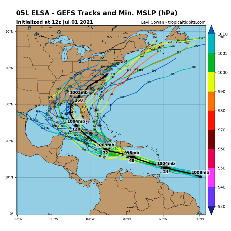
While Elsa is moving at 28 mph now, the National Hurricane Center (NHC) says an even faster motion toward the west-northwest is expected over the next 24 to 36 hours. On the official NHC forecast track, Elsa will pass near or over portions of the Windward Islands or the southern Leeward Islands on Friday, move into the eastern Caribbean Sea late Friday and Friday night, and move near the southern coast of Hispaniola on Saturday. By early Sunday, Elsa is forecast to move near portions of eastern Cuba. As Elsa moves west through the Caribbean, some additional strengthening is forecast during the next 48 hours.
During the weekend, Elsa is expected to interact with Haiti and Cuba; the high terrain there could hinder development or even weaken the system. However, if the system moves fast, it may not have a chance to weaken, and an expected slow-down north of Cuba could lead to substantial intensification as it enters the Florida Straits or the Gulf of Mexico.
Beyond Cuba, forecast guidance suggests Elsa could strike the Gulf coast of Florida and then head north and east across the state, perhaps exiting near the Jacksonville, Florida coast before pushing up the U.S. East Coast. Other models suggest the system may just stay inland of the coast, moving up from the Florida panhandle into the Mid Atlantic by the middle to later part of next week.
For now, though, tropical storm conditions are expected in portions of the Windward and southern Leeward Islands within the warning areas on Friday. Tropical storm conditions are also possible in the watch areas on Friday. Elsa is expected to produce rainfall totals of 3-6″ with maximum totals of 10″ on Friday across the Windward and southern Leeward Islands, including Barbados. Over Puerto Rico, rainfall of 1-3″ with localized amounts of 5″ are expected Friday into Saturday. The heavy rain in the islands could lead to flash floods, mudslides, and rock slides.
