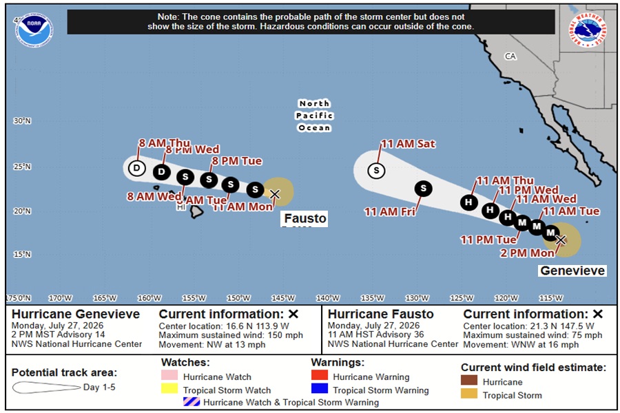
Hurricanes Fausto and Genevieve continue to spin about in the open waters of the Pacific Ocean between Hawaii and California; they are both forecast to dodge Hawaii as weakening tropical cyclones, but even so, are expected to pound the state with rough, potentially life-threatening surf for the next several days.
Hurricane Fausto is the closest of the two storms to Hawaii and the weakest. With maximum sustained winds of 75 mph, the storm is barely a Category 1 hurricane on the Saffir-Simpson hurricane wind scale. Located about 505 miles east-northeast of Hilo on the Big Island of Hawaii, the storm is moving to the west-northwest at 16 mph while the minimum central pressure is down to 994 mb or 29.36″.
The latest National Hurricane Center (NHC) forecast continues a general west-northwestward motion for Fausto while it weakens. Most wind and rain associated with this tropical cyclone will remain well north of the state. However, surf generated by Fausto will continue to build westward across Hawaii along exposed east-facing shores through Tuesday as Fausto approaches and begins to pass north of the islands. Large surf and strong currents will lead to dangerous conditions along exposed shores.
Meanwhile, Hurricane Genevieve is a much stronger hurricane but could be a less threat to Hawaii over time.
As of the latest advisory from the NHC, Genevieve was located about 505 miles south-southwest of the southern tip of Baja California. With maximum sustained winds of 150 mph, the storm is a powerful Category 4 hurricane on the Saffir-Simpson scale just 6 mph shy of becoming a Category 5 hurricane again. The storm is moving northwest at 13 mph while its minimum central pressure is 934 mb or 27.58″.
The NHC expects Genevieve to travel in a west-northwestward to northwestward motion with some decrease in forward speed during the next couple of days. Some fluctuations in intensity are possible this afternoon, but steady weakening is forecast to begin by tonight through the remainder of the week.
Like Fausto, Genevieve is forecast to pass to the north of Hawaii with time.
The estimated minimum central pressure is 934 mb (27.58 inches).
Right now, swells generated by Genevieve are affecting portions of the southwestern coast of Mexico and southern portions of the Baja California Peninsula, and will spread northward along the remainder of the west coast of the Baja California Peninsula by tonight. These swells are likely to cause life-threatening surf and rip current conditions there. The storm is too far away to impact Hawaii surf at this time but that could change in the days ahead.
For now, the surf from Fausto is the pressing concern. A building east swell from the hurricane will cause surf heights to build to High Surf Warning levels today which will peak on Tuesday. High Surf Warnings are in effect for the east facing shores of Hawaii Island, Maui, Oahu, and Kauai.
“Expect very strong breaking waves and powerful currents. Waves breaking in channel entrances may make navigating the channels dangerous,” warns the National Weather Service office in Honolulu on the island of Oahu. “Stay away from the shoreline along the affected coasts. Be prepared for road closures. Postpone entering or leaving channels affected by the high surf until the surf subsides.”
While surf is the primary concern with Fausto, the National Weather Service doesn’t want people in Hawaii to let their guard down until the storm passes.
“The environment ahead of Fausto grows more unfavorable on approach to the islands and we expect it to weaken into a tropical storm before arrival in the vicinity of the Hawaiian Islands,” wrote Honolulu based meteorologists in their latest Forecast Discussion. “That said, we remain cautious at this stage that even subtle southern shifts in the track or delayed weakening trends may still produce changes to our island by island impacts,” they add.
“We strongly encourage the public to pay close attention to this passing storm system as weather impacts over the Hawaiian Islands will evolve the closer Fausto gets,” the National Weather Service wrote, adding, “No time like the present to review your family hurricane preparedness plans, and ensure every household has at least a 14 day supply of food and water available if needed during this years active hurricane season.”
