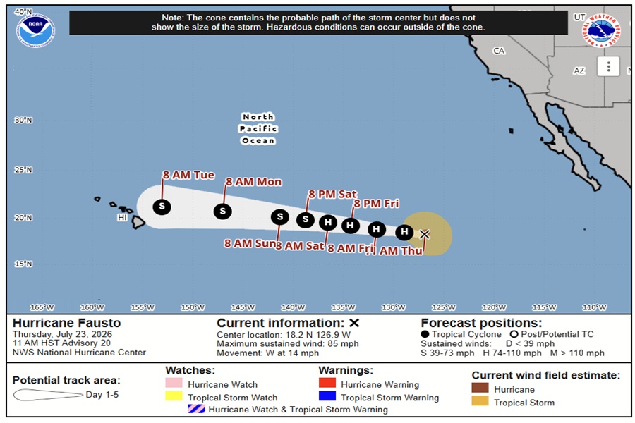
The Aloha State may have an unwelcome visitor in about 5 days; Hurricane Fausto is spinning about in the open waters of the eastern Pacific Ocean and is heading in the general direction of Hawaii. However, the National Hurricane Center expects Fausto to weaken significantly over the coming days and the system may not even make a direct impact to the islands.
As of the latest advisory from the National Hurricane Center (NHC), Hurricane Fausto was located near 18.2N 126.9W which is about 1,840 miles due east of Hilo, Hawaii. With maximum sustained winds of 85 mph and estimated minimum central pressure of 980 mb or 28.94″, the storm is moving to the west at 14 mph.
The NHC expects Fausto to continue its march west over the next few days. While its forward motion won’t change, its intensity will. Maximum sustained winds have increased to near 85 mph today
with higher gusts, making the hurricane a mid-range category 1 storm on the Saffir-Simpson wind scale.
“Small intensity fluctuations are possible today, followed by slow weakening through the weekend,” advises the NHC.
After struggling with dry air intrusions earlier today, Fausto has managed to close off an eyewall. The NHC says that slight additional near-term strengthening cannot be completely ruled out if the hurricane maintains this structure. However, water vapor imagery from the GOES-West weather satellite indicates that the hurricane is moving into an increasingly drier air mass over marginal sea surface temperatures and there is the potential for westerly mid-level shear to introduce drier air into the circulation once again.
“This forecast keeps Fausto a tropical cyclone through day 5, but the drier and more stable air mass over the Central Pacific will likely make it difficult for Fausto to maintain organized convection by early next week,” says the NHC.
Officially, Fausto is forecast to weaken to a mid-range tropical storm in 5 days, and as the NHC, such a forecast strength may be generous. The forecast also brings the center of circulation north of the islands, which would also limit direct impacts to the Aloha State.
“While the longer-range forecast brings the center of Fausto generally toward the main Hawaiian Islands, it is too early to discuss any potential impacts,” cautions the NHC.
Even when storms remain offshore from Hawaii, they can bring dangerous surf, coastal flooding, heavy rainfall, and gusty winds, depending on their size and proximity. Because of the high-pressure ridge and typically cooler ocean waters around the state, many Eastern Pacific storms weaken or are steered north or south of the island chain. It appears the same will happen with Fausto, but it is still too soon to say with any degree of certainty what if any impacts the storm or its remnants will have on Hawaii.
For now, swells generated by Fausto are affecting the west coast of the Baja California Peninsula and the coast of southern California. The National Hurricane Center says that these swells are likely to cause life-threatening surf and rip current conditions there. Other than those swells, Fausto isn’t impacting the weather anywhere else in Hawaii or the U.S. and Mexican west coast.
