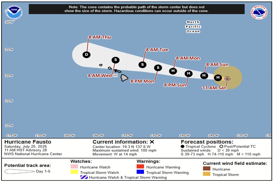
Hurricane Fausto continues to spin about in the Pacific Ocean, moving in the general direction of Hawaii. The storm is forecast to dodge the state to its north, but it should still be close enough to influence the weather in the Aloha State while impacting the island chain with life-threatening surf.
As of the latest advisory from the National Hurricane Center, Hurricane Fausto had maximum sustained winds of 100 mph; it was located about 1,140 miles due east of Hilo on the Big Island of Hawaii. The storm is moving to the west at 14 mph. The minimum central pressure is estimated to be 971 mb or 28.68″.
The National Hurricane Center (NHC) expects Fausto’s general motion to the west to to continue for the next several days. At the same time, gradual weakening is forecast during the next several days.
The NHC says Fausto is moving into a drier mid-level environment over marginal sea-surface temperatures, and southwesterly vertical wind shear is expected to increase after 36 hours while the system moves over the central Pacific basin.
“The intensity models unanimously agree that Fausto will weaken on its approach to the Hawaiian Islands,” said the NHC in their latest forecast discussion. “The NHC intensity forecast is similar to the previous one and remains near the simple (IVCN) and corrected (HCCA) consensus aids. A faster rate of weakening is shown from 60-120 hours once environmental conditions become increasingly hostile.”
As Fausto moves toward the Hawaiian Islands, the wind field is predicted to shrink and become asymmetric, with the strongest winds becoming displaced to the northern side of the circulation. The core precipitation from Fausto should remain north of all the islands, especially the Big Island of Hawaii. While the core wind field will remain to the north too, winds and trade winds could become dynamic before, during, and after the storm’s passage. While the core wind and rain will miss Hawaii, soaking downpours and isolated damaging wind gusts cannot be ruled out.
A narrow subtropical ridge over the eastern and central Pacific Ocean continues to steer the hurricane toward the west. Fausto is expected to maintain this westward heading through early next week, bringing the system into the central Pacific basin tomorrow and toward Hawaii thereafter. A mid-level trough over the north-central Pacific may weaken the steering ridge enough early next week to induce a more west-northwestward motion later in the period.
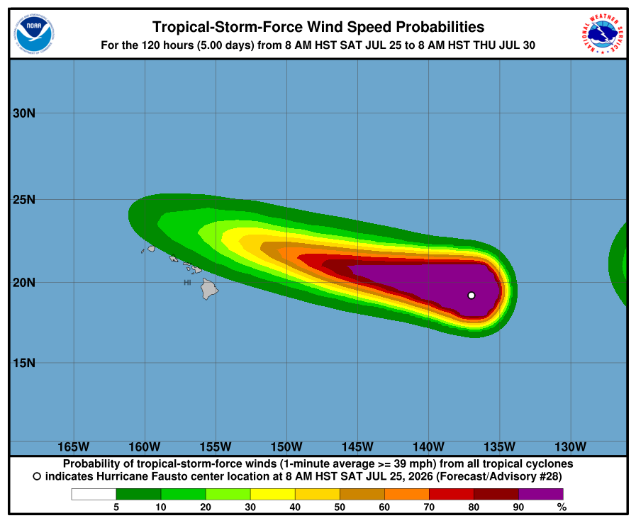
“The track guidance trended northward once again and is coming into better agreement that Fausto should pass near but to the north of the Hawaiian Islands, making its closest approach during
the middle of next week,” the NHC said.
One hazard that is becoming likely is dangerous surf impacts state-wide. Surf generated by Fausto is expected to begin building across east-facing shores of the eastern end of Hawaii on Sunday, spreading westward Sunday night into Monday, and continue building through Tuesday as Fausto approaches and moves into the area. These swells are likely to cause life-threatening surf and rip current conditions.
The National Hurricane Center is promoting two key messages.
The first key message is that Fausto is expected to weaken as it approaches the Hawaiian Islands early next week. While the chances of the strongest winds and heaviest rainfall remaining offshore north of the islands are increasing, interests across Hawaii should continue to monitor the progress of Fausto.
The second key message is confidence is high that swells generated by Fausto will reach the Hawaiian Islands well in advance of the cyclone, producing increasing surf and dangerous rip currents. Surf is expected to begin building across east-facing shores of the eastern end of the state on Sunday, spreading westward Sunday night into Monday, and continue building through Tuesday as Fausto approaches and moves into the area.
