The National Hurricane Center (NHC) in Miami, Florida has upgraded the Tropical Storm Watch that was in effect to a Tropical Storm Warning for the Florida Keys and Florida Bay. The NHC has also extended the remaining Tropical Storm Watch to extend north from Bonita Beach to Englewood, Florida. A Tropical Storm Warning means that tropical storm conditions are expected somewhere within the warning area within 36 hours while a Tropical Storm Watch means that tropical storm conditions could be possible there.
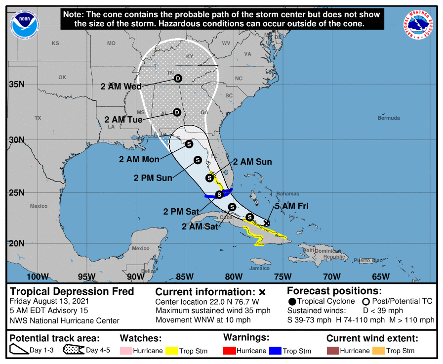
As of the 5 am advisory from the NHC, Fred was located about 370 miles east-southeast of Key West, Florida and about 125 miles south-southwest of Great Exuma Island. With maximum sustained winds of 35 mph and a minimum central pressure of 1013 mb or 29.92″, Fred is classified as a Tropical Depression. It is moving to the west-northwest at 10 mph.
The National Hurricane Center is concerned about the storm’s future strength and path. The depression’s west-northwest movement is expected to continue today, with a turn to the northwest is expected tonight or Saturday. On the forecast track, Fred is expected to move along or just north of eastern and central Cuba through tonight, be near the Florida Keys on Saturday, and near the west coast of Florida on Sunday. The NHC says slow strengthening is expected during the next couple of days, and Fred could become a Tropical Storm again later today.
Currently, no major computer forecast model suggests Fred will gain enough strength to become a hurricane, but even as only a Tropical Storm, Fred could bring serious problems to the Sunshine State. Heavy rain, strong winds, and rough surf are all possible from Fred, along with isolated tornadoes.
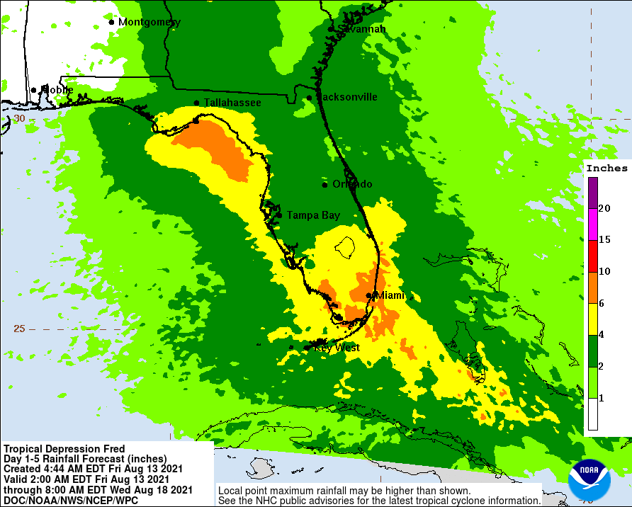
Tropical Depression Fred is expected to produce 3-5″ of rain with isolated amounts to 8″ in the Bahamas and 3-7″ across the Keys, southern, and central Florida towards the Big Bend with isolated totals of 10″. Heavy rainfall could lead to areal, urban, and small stream flooding, and potentially worsen ongoing minor to isolated moderate river flooding over northern Florida. Beyond Sunday, heavy rain and flood impacts could extend into inland portions of the Southeast and into the southern and central Appalachians and Piedmont as Fred interacts with a front in the area.
Tropical storm force wind conditions are expected across the Florida Keys, in the warning area, on Saturday. Tropical storm conditions are possible in the watch area in the rest of south Florida beginning Saturday too.
Swells generated by Fred are expected to spread across portions of the Bahamas and the northern coast of Cuba through tonight. These swells could reach the Florida Keys and southern Florida by early Saturday and increase along the west coast of Florida Saturday night and Sunday.While rough surf is likely, a catastrophic storm surge is unlikely with this storm at this time.
