• Skip to primary navigation
  • Skip to main content
  • Skip to primary sidebar

Weatherboy

Weatherboy Weather News, Maps, RADAR, Satellite, and Forecasts.

  • Local
  • Earth Science News
  • RADAR
  • Current Warnings
  • Satellite
  • Current Maps
  • Forecast Maps
  • Video

Tropical Cyclone Could Be Forming Near Florida

by Weatherboy Team Meteorologist - December 19, 2021

Simulated IR satellite view of the Florida area late Monday night / early Tuesday morning shows an area of low pressure developing along the Florida Gulf coast. This simulation is based on GFS computer forecast model data. Image: tropicaltidbits.com


A tropical cyclone could be forming soon near the Florida Gulf coast;  while the Atlantic Hurricane Season ended on November 30, it is possible to have tropical cyclones in the off-season in December.

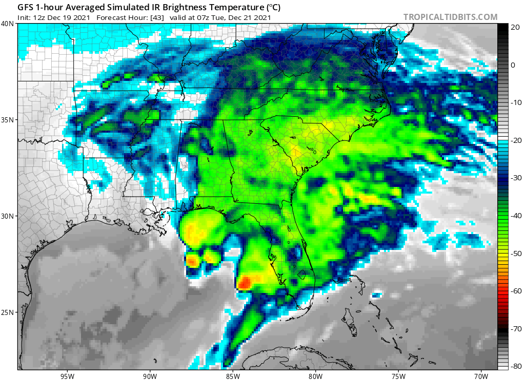
Two key global computer forecast models, the American GFS and European ECMWF, suggest an area of low pressure will form in the northeastern Gulf of Mexico off the Florida west coast; this storm system could develop subtropical or tropical storm characteristics and briefly become a named storm over time.

Temperatures in the Gulf of Mexico west of Florida are running 1-3 degrees Celsius above normal right now. Image: NWS

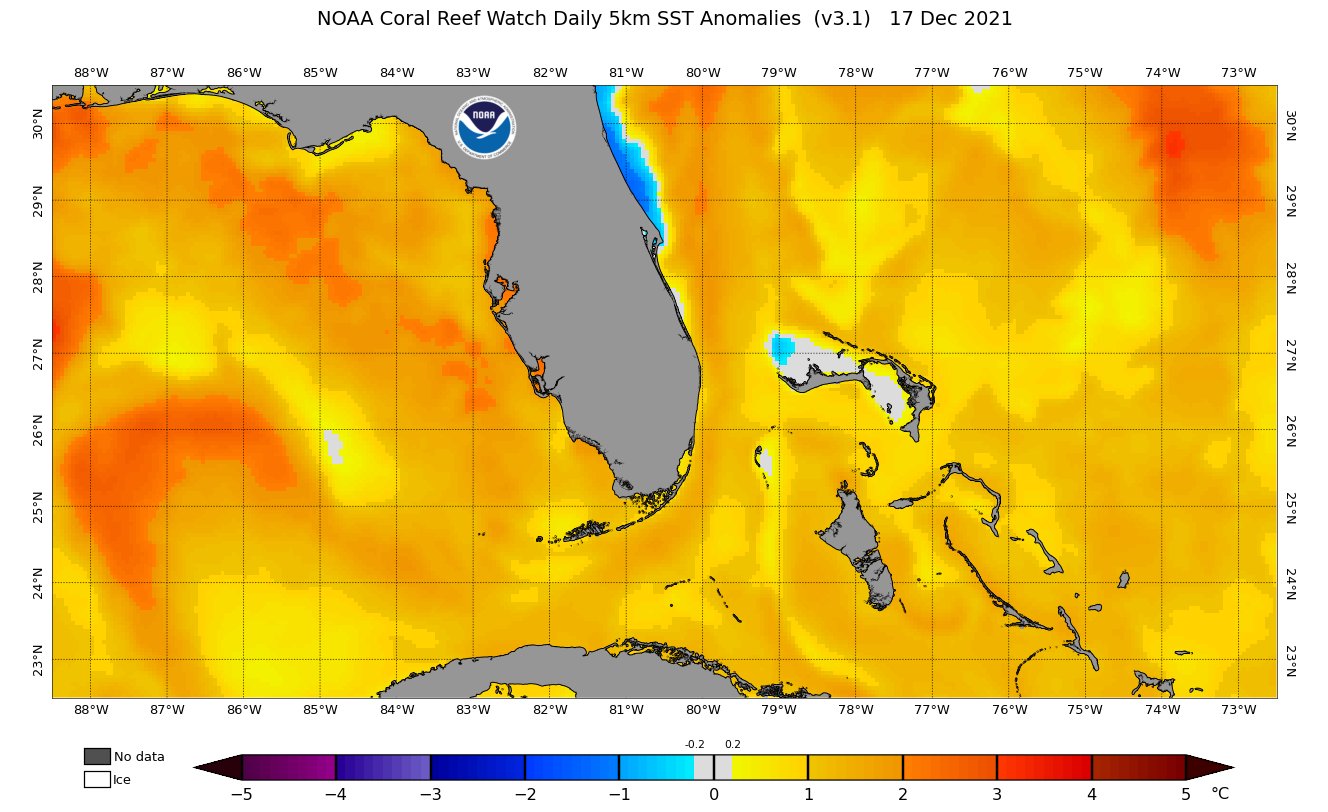
Helping fuel the possibility of a tropical cyclone forming are very warm water temperatures in the Gulf of Mexico. According to NOAA data, temperatures in much of the Gulf of Mexico ate 1-2 degrees Celsius above normal; temperatures near the Florida coastline are even warmer at about 3 degrees Celsius above normal. These above normal water temperatures could help fuel a tropical disturbance there.

The National Hurricane Center (NHC) in Miami, Florida has yet to officially comment on the disturbance. The NHC’s last Tropical Outlook product was issued at 7pm on November 30. In that last statement, the NHC wrote, “Routine issuance of the Tropical Weather Outlook will resume on May 15, 2022. During the off-season, Special Tropical Weather Outlooks will be issued as conditions warrant.” As such, it is possible the NHC may address this system in the Gulf soon.


Even if a tropical cyclone does form, it shouldn’t get too large nor strong. Computer guidance suggests wind-whipped soaking rain showers and storms over portions of Florida, Georgia, and South Carolina as it moves from southwest to northeast across Florida. By Tuesday night it is well off the southeast coast; by Thursday morning, there would no longer be clouds associated with this storm over the southeast. And because the storm will move north and east rapidly, it is not expected to come up the east coast into the Mid Atlantic and New England at this time.

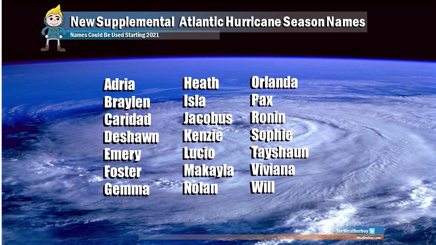
The last tropical storm of the 2021 Atlantic Hurricane Season was Wanda, which tracked across the Atlantic in early November. As the 21st storm of the season, Wanda exhausted the name list scientists at the National Hurricane Center use for storm names.


Instead of Greek letters, names from this supplemental list will be used as needed in the Atlantic basin. Unlike the standard lists that rotate every 6 years, these names will remain the same each year unless they become retired. Image: Weatherboy

Unlike in previous years where the NHC would switch over to letters of the Greek alphabet, this year they would pull from an extra list of names in alphabetical order. A decision was made earlier this year to change the naming process when the first batch of names is used up. Should a storm beyond Wanda require a name, the next storm name to be used would be Adria.

Primary Sidebar

Sponsored Ad

Search

Latest News

  • Igloo Cooler Recalled Due to Amputation / Crushing Threat
  • Longtime TV Meteorologist Fired
  • Spacecraft Launched by Soviet Union in 1972 Crashed Back on Earth Today
  • Strong Tennessee Earthquake Reported by 35,000+ People
  • Updated Crash Forecast Puts Eastern U.S. on Alert from Soviet Union Spacecraft
  • Soviet Union Spacecraft Crash Zones Updated; NJ/NY/PA/MI at Increased Risk
  • Over 2,000 People Report Shaking from Virginia Earthquake
  • Morning Earthquake Strikes Heart of New Madrid Seismic Zone in Missouri Today
About | Careers | Contact | Contests
Terms | Privacy | Ad Choices
Weatherboy is a (R) Registered Trademark of isarithm LLC, All Rights Reserved.
All content herein is Copyright by Isarithm LLC 1997-2022