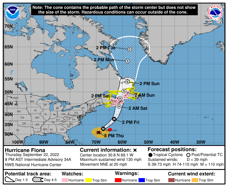
Major Hurricane Fiona appears to be on a collision course with Canada, with Hurricane Watches up for portions of Atlantic Canada that rarely see tropical cyclones. According to Environment Canada, the Canadian equivalent of the U.S.’s National Weather Service, there’s been about two dozen hurricanes or post-tropical cyclones to strike the Atlantic Canada coast since 1951; Hurricane Fiona could be the strongest. In 2021, Larry struck the Canadian coastline; in 2020, both Teddy and Isaias struck Atlantic Canada. And now it looks like Fiona will be the next to strike the region, with impacts starting later this week.
Due to the threats posed by a likely direct hit, many watches are in effect in Canada. A Hurricane Watch is in effect for Nova Scotia from Hubbards to Brule, Prince Edward Island, Isle-de-la-Madeleine, and Newfoundland from Parson’s Pond to Indian Harbour. A Tropical Storm Watch is in effect for St. Andrews New Brunswick to west of Hubbards, Nova Scotia, west of Brule Nova Scotia to Cap Madeleine, Quebec, Anticosti Island, Sheldrake, Quebec to north of Parson’s Pond, Newfoundland, West Bay, Labrador to Hare Bay, Newfoundland, and Indian Harbour to St Lawrence, Newfoundland. A Hurricane Watch means that hurricane conditions are possible within the watch area. A Tropical Storm Watch means that tropical storm conditions are possible within the watch area, generally within 48 hours.
Hurricane Fiona is also about to make its closest approach to Bermuda tonight; while a direct impact isn’t likely, the storm is so wide that tropical storm force winds are likely and hurricane force conditions are possible tonight. Because of these threats, Bermuda is under a Hurricane Warning now.
In the last update from the National Hurricane Center, Hurricane Fiona with its maximum sustained winds of 130 mph was located about 280 miles west-southwest of Bermuda and about 1,000 miles south-southwest of Halifax, Nova Scotia. The storm is moving to the north-northeast at 20 mph. The storm’s minimum central pressure is 932 mb or 27.52. Fiona is a Category 4 hurricane on the Saffir-Simpson hurricane wind scale.
According to the National Hurricane Center (NHC), a Fiona will continue its north-northeastward or northeastward motion with tonight with an expected increase in forward speed through to tomorrow, followed by a somewhat slower northward motion beginning Friday night, and this motion should continue through late Saturday.
On the forecast track, the center of Fiona will pass just to the west of Bermuda tonight, approach Nova Scotia on Friday, and move across Nova Scotia and into the Gulf of St. Lawrence on Saturday. Some slight weakening is expected to begin tonight or Friday, however, the NHC says that Fiona is forecast to be a large and powerful post-tropical cyclone with hurricane-force winds when it moves over Nova Scotia Friday night and Saturday. Hurricane-force winds extend outward up to 70 miles from the center and tropical-storm-force winds extend outward up to 275 miles; when the storm nears Nova Scotia, it could even be wider.
The strongest hurricane to impact Canada to date was 2003’s Juan; the category 2 storm made landfall in central Nova Scotia on September 29 as a category 2 storm with 100 mph winds. It is possible winds with Fiona could be stronger than that.
In the meantime, hurricane conditions are expected on Bermuda beginning tonight and continuing through Friday morning. Tropical storm conditions are expected to begin on Bermuda during the next few hours. Hurricane conditions are possible in portions of the hurricane watch area in Canada by late Friday night. Tropical storm conditions are possible in portions of the tropical storm watch
area in Canada by late Friday.
While Fiona will drop 2-4″ of rain on Bermuda, 3-6″ with isolated amounts of 10″ of rain are possible in Canada. These heavy rains can create flood problems, making any travel hazardous.
A storm surge will cause elevated water levels along the coast of Bermuda in areas of onshore winds beginning tonight. Near the coast, the surge will be accompanied by large and destructive waves. Canada could be impacted by storm surge too; a dangerous storm surge could produce coastal flooding within the watch areas in Atlantic Canada. Near the coast, the surge will be accompanied by large and destructive waves.
Even away from the storm, surf and swells will become problematic. Swells generated by Fiona are affecting the Turks and Caicos Islands, the Bahamas, the southeastern United States coast, and Bermuda now. These swells will continue to spread northwestward across the western Atlantic toward the mid-Atlantic and northeast coasts of the United States over the next day or so. The swells will also reach Atlantic Canada on Friday. These swells are likely to cause life-threatening surf and rip current conditions; even experienced surfers and swimmers should avoid the ocean until the hurricane is long gone.