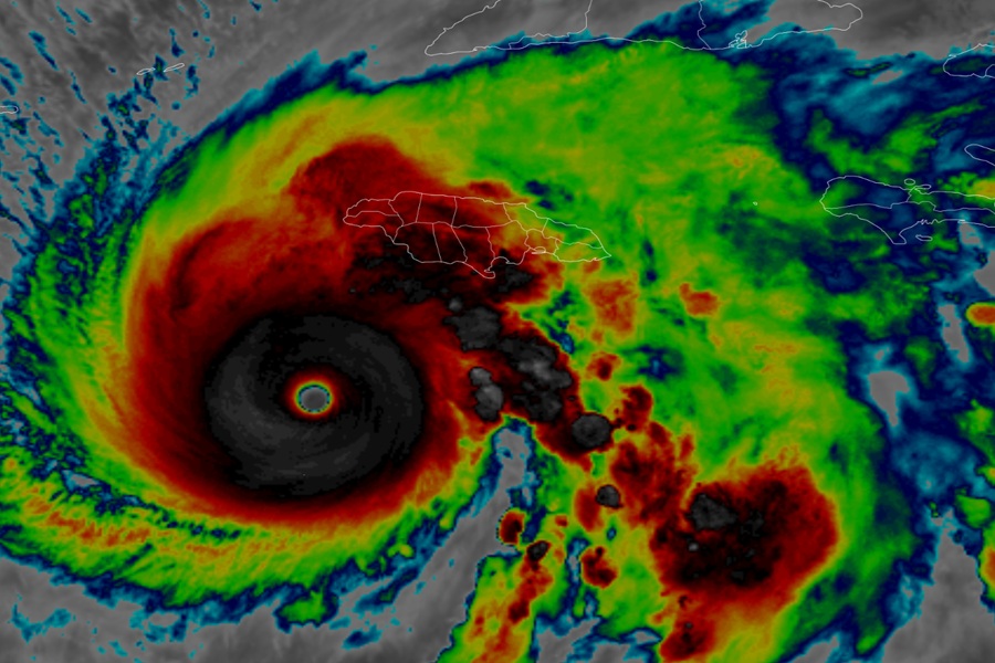
In an absolute worse-case scenario for Jamaica, slow moving Major Hurricane Melissa, a high-end category 5 hurricane on the Saffir-Simpson hurricane wind scale, is forecast to smash into Jamaica tomorrow bringing apocalyptic results: wind gusts over 210 mph, rain totals in the 3-5 foot range, and an epic storm surge of more than 12 feet tall –excluding the 10-30 foot waves on top are all due to bring significant catastrophic destruction to the island nation on Tuesday. Melissa became the strongest hurricane this late in the season for the Atlantic basin and is among the top 5 strongest hurricanes ever measured in the Atlantic basin; many weather records are likely to fall as the storm smashes through the Caribbean.
While Jamaica, which has already seen significant wind and rain damage and deaths, will see the full impacts on Tuesday, there’s growing concern for future impacts along the forecast path of this epic, record-breaking storm. A variety of tropical advisories are now in effect across a broad area. For now, a Hurricane Warning is in effect for Jamaica, the Cuban provinces of Granma, Santiago de Cuba, Guantanamo, and
Holguin, and the Southeastern and Central Bahamas. A Hurricane Watch is in effect for the Turks and Caicos Islands. A Tropical Storm Warning is in effect for Haiti, the Cuban province of Las Tunas, and the Turks and Caicos Islands.
A Hurricane Warning means that hurricane conditions are expected somewhere within the warning area. A warning is typically issued 36 hours before the anticipated first occurrence of
tropical-storm-force winds, conditions that make outside preparations difficult or dangerous. A Hurricane Watch means that hurricane conditions are possible within the watch area. A watch is typically issued 48 hours before the anticipated first occurrence of tropical-storm-force winds, conditions that make outside preparations difficult or dangerous. A Tropical Storm Warning means that tropical storm conditions are expected somewhere within the warning area within 36 hours.
According to the 11 pm advisory from the National Hurricane Center (NHC) in Miami, Florida, Major Hurricane Melissa’s maximum sustained winds are 175 mph with gusts to 215 mph while the central minimum pressure is down to 903 mb or 26.67″. With pressure that low, Melissa has the 7th lowest pressure ever measured in an Atlantic hurricane. The storm is drifting at 2 mph in the north-northeast direction, inching its way to Jamaica which it should hit as a Category 5 hurricane on Tuesday –the strongest hurricane on record to strike the island.
The National Hurricane Center warns people on Jamaica: “Remain in your safe shelter. Catastrophic flash flooding and numerous landslides are expected through Tuesday. The eyewall’s destructive winds may cause total structural failure, particularly in higher elevations, leading to widespread infrastructural damage, prolonged power and communication outages, and isolated communities. Along the southern coast, life-threatening storm surge and damaging waves are anticipated through Tuesday. Failure to take immediate
action may result in serious injury or significant loss of life.”
