Tropical Storm Nicole continues to grow in size and strength and is forecast by the National Hurricane Center to strike Florida’s east coast as a hurricane soon. While Florida will experience the strongest winds from this storm, flooding rains, coastal flooding, damaging winds, and the risk of scattered tornadoes will extend far up and down much of the eastern United States far away from the point of initial landfall.
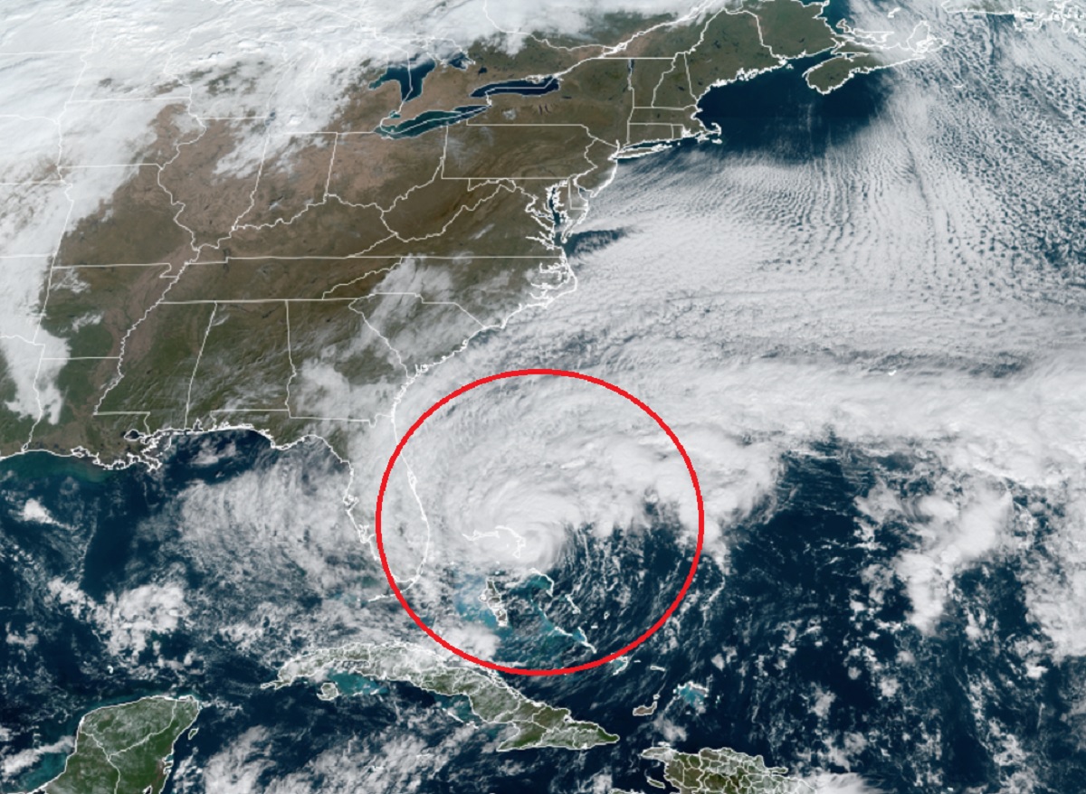
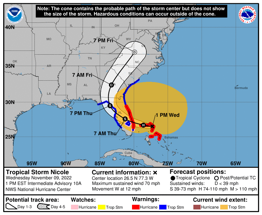
In the latest update from the National Hurricane Center, Nicole was a high-end tropical storm with maximum sustained winds of 70 mph, just a few miles per hour shy of being classified as a Category 1 hurricane. The storm is about 10 miles west of Marsh Harbor on Great Abaco Island and about 175 miles due east of West Palm Beach, Florida. Nicole is moving to the west at 12 mph. Minimum central pressure is now down to 985 mb or 29.09″.
Nicole is a very large tropical storm. Tropical-storm-force winds extend outward up to 460 miles especially to the north of the center. A private weather station on Elbow Cay, just east of Great Abaco Island, recently reported sustained winds of 43 mph and a wind gust of 59 mph. The National Ocean Service station at the Lake Worth Pier, Florida, recently reported a wind gust of 59 mph.
Hurricane conditions and a dangerous storm surge are expected in portions of the northwestern Bahamas today, where a Hurricane Warning is in effect. Hurricane conditions are expected across portions of the coast of southeast and east-central Florida beginning this evening or tonight, where a Hurricane Warning is in effect. Tropical storm conditions have begun along the east coast of Florida in the warning areas and will spread northward to Georgia and South Carolina later today. Tropical storm conditions are expected to begin along the west coast of Florida within the warning area this
evening or tonight.
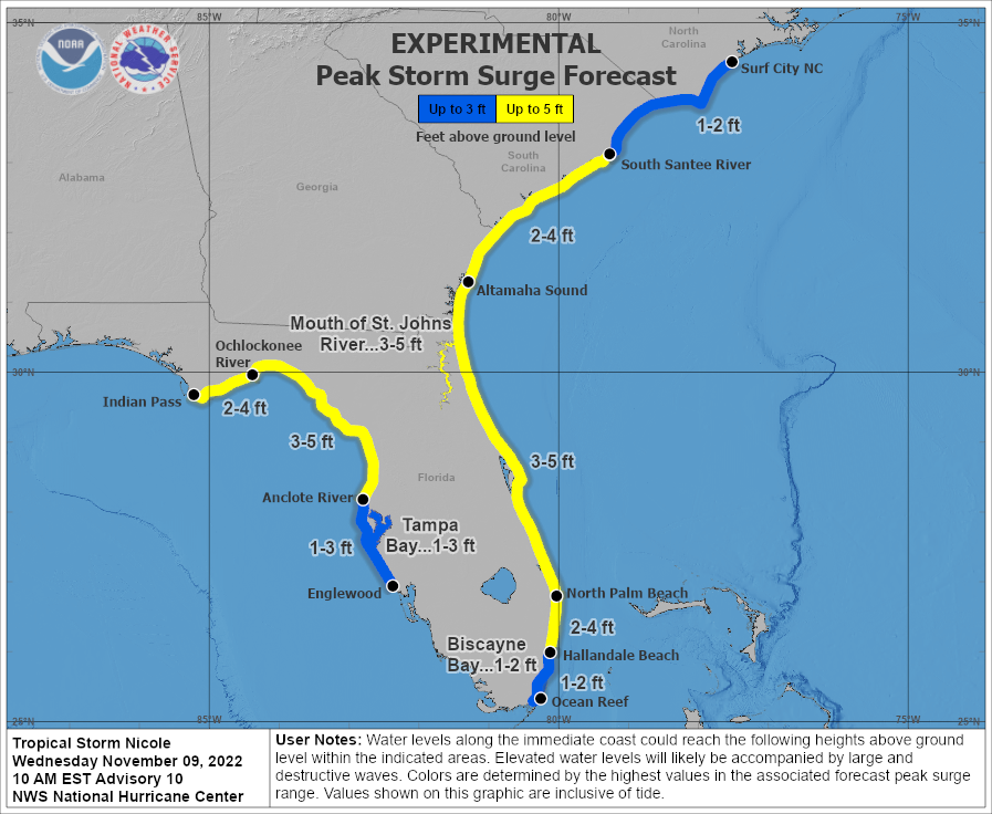
A dangerous storm surge is expected along much of the east coast of Florida, portions of coastal Georgia, and the Florida Big Bend along the Gulf coast. The storm surge will be accompanied by large and damaging waves along the Atlantic coast. The National Hurricane Center is urging residents in the warning area should listen to advice given by local officials.
The National Hurricane Center cautions people to not focus on the exact track of Nicole since it is a large storm with hazards extending well to the north of the center, outside of the forecast cone. These hazards will affect much of the
Florida peninsula and portions of the eastern United States.
Nicole will produce heavy rainfall today into Thursday across the Florida Peninsula. Flash and urban flooding will be possible across portions of the Florida Peninsula along with river rises on the St. Johns River. Isolated flash, urban, and small stream flooding will also be possible on Friday in the Southeast through the southern and central Appalachians, including the Blue Ridge Mountains, and extending northward through west central Pennsylvania into western New York by Friday night.
Heavy rain will spread up the interior northeast by Saturday, bringing a flood threat to portions of West Virginia, western and central Pennsylvania, and western and central Upstate New York. Several inches of rain can fall in a short period, resulting in flash flood problems. The National Weather Service warns: “Turn around, don’t drown; never drive through flood waters.”

In addition to hazards from rain and wind, there is also a threat of severe thunderstorms and tornadoes across the coastal plain. This threat peaks on Thursday, with the threat of severe weather over southeastern Pennsylvania, southern New Jersey, Maryland, Delaware, Virginia, and the Carolinas. The greatest risk of severe weather and tornadoes will be over eastern North and South Carolina. People in this area should be on alert should Tornado Watches or Warnings be issued.
By late Saturday night, what’s left of Nicole should head north and east out over Atlantic Canada and the Atlantic Ocean, allowing for cooler and drier air to return in its wake.
The Atlantic Hurricane Season runs through to the end of this month.
