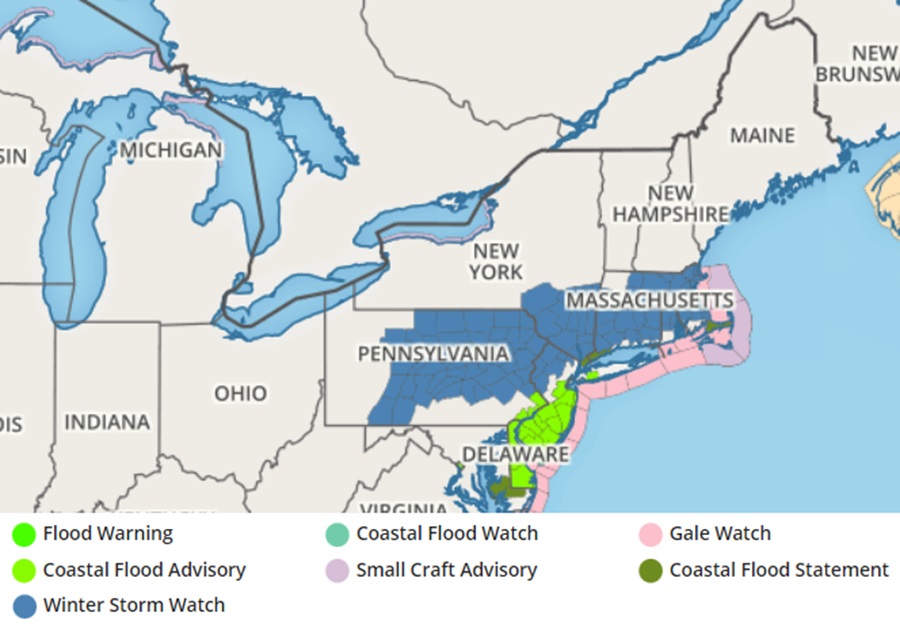
A strong cyclone is forecast to bomb-out near New Jersey in the coming days, bringing heavy rain, snow, and strong winds to the northeast in the days leading up to Valentine’s Day. Due to the likelihood of severe winter weather, the National Weather Service has issued Winter Storm Watches across portions of Pennsylvania, New Jersey, New York, Connecticut, Rhode Island, and Massachussetts.
Low pressure will track out of the Tennessee Valley and up the Appalachians by Monday night, then transfer to an intensifying coastal storm which will track off the Mid-Atlantic coast during Tuesday. As it passes over or near New Jersey, it’ll “bomb-out” and deepen rapidly, leading to a rapid intensification of the storm. This rapid intensification will help wrap cold air around on the backside of the storm while it’ll also help drive wind speeds up, especially along the Jersey Shore, around Long Island, and extreme southeastern New England.
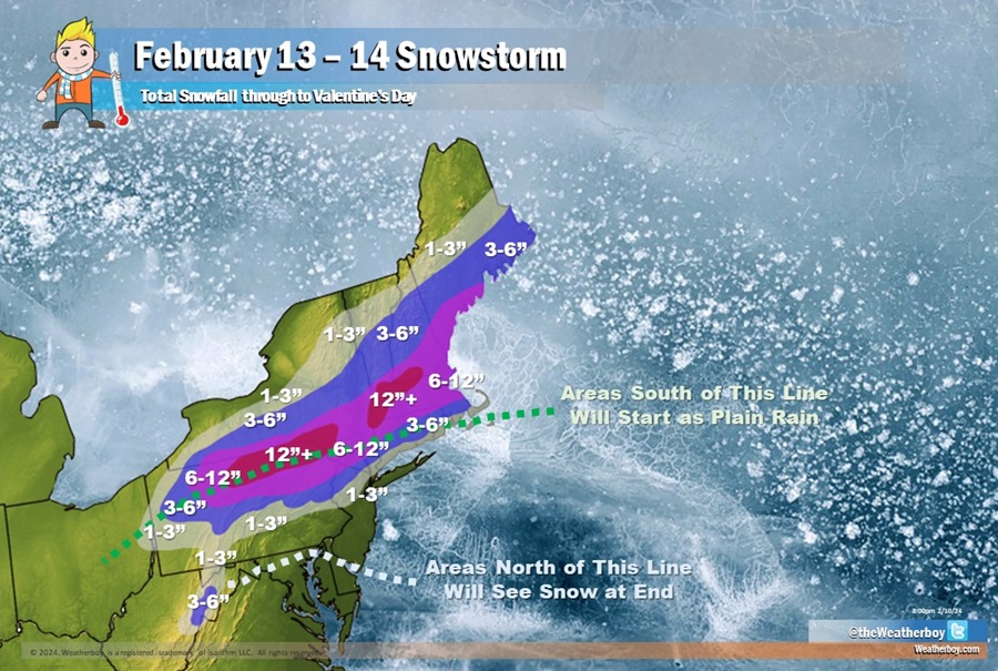
Precipitation will start as plain rain for many places, including Philadelphia and New York; the initial rain/snow line will be close to the Pennsylvania/New York state line and interior southern New England. But as cold air wraps into the system, the rain will change to snow. In areas north of I-78 and I-80 in New Jersey and Pennsylvania, the snow will fall heavy at times and accumulate well, with the peak heavy snow time here during the Tuesday morning commute time. But even though a transition to plain snow is expected later Tuesday for the I-95 corridor from New York City south to northern Delaware, accumulations will be minimal, if at all. Most snow will fall over interior locations north and west of New York City, with some areas expected to see over a foot of snow over portions of northern Pennsylvania, southern Upstate New York, far northwestern Connecticut, and western Massachussetts. While Boston will see 6-12″ of snow, New York City may only see an inch or two at most from what will be an otherwise predominantly rain storm. The same is true for Philadelphia and Central New Jersey, especially south of Route 33 and I-195, where while snow flakes are likely to fly on the backside of this storm, accumulations will be close to zero.
Minor to moderate coastal flooding is forecast with the Tuesday high tide for the Atlantic coasts of New Jersey, Delaware Bay, and the tidal Delaware River. Dangerous marine conditions are possible late Monday night into Tuesday with gale force winds and seas of 6-9 feet.
The National Weather Service says a widespread 1-1.5″ of rain is forecast to fall on the rainy south side of this storm. However, the National Weather Service says that fresh water flooding is not expected to pose a threat.
Beyond precipitation, wind will be another weather hazard associated with this storm. Strong winds with gusts 40-50 mph are possible which may result in wind damage and power outages; this threat will be greatest along the Jersey Shore and Delaware Beaches.
By Tuesday night, the storm will pull away from the northeast and completely exit it on Wednesday, Valentine’s Day. For those where heavy snow is expected to fall, they will have a fair, calm, and cold Valentine’s Day to dig out.
