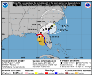
The East Coast is bracing for the potential of catastrophic flooding from Tropical Storm Debby which is forecast to intensify into a hurricane before plowing into Florida and slowly drifting up the U.S. East Coast. Numerous warnings and advisories for the storm are up and forecasters with the National Hurricane Center (NHC) and National Weather Service (NWS) are urging residents to prepare for the worst.
Right now, a Storm Surge Warning is in effect for the Florida coast from the middle of Longboat Key northward to Indian Pass including Tampa Bay, Georgia and the South Carolina coast from the Mouth of the St. Mary’s River to South Santee River in South Carolina. A Storm Surge Watch is in effect for the Florida coast from Bonita Beach northward to the middle of Longboat Key, including Charlotte Harbor. A Storm Surge Warning means there is a danger of life-threatening inundation, from rising water moving inland from the coastline, during the next 36 hours in the indicated locations while a Storm Surge Watch means there is a possibility of life-threatening inundation, from rising water moving inland from the coastline.

A Hurricane Warning is now in effect for the Florida coast from the Suwannee River to Indian Pass while a Hurricane Watch is in effect for the Florida coast south of the Suwannee River to Yankeetown. A Hurricane Warning means that hurricane conditions are expected somewhere within the warning area. Preparations to protect life and property should be rushed to completion. A Hurricane Watch means that hurricane conditions are possible within the watch area and people should plan as if a Hurricane Warning may be issued there too.
A Tropical Storm Warning is in effect for the Florida coast south of the Suwannee River to Bonita Beach, the Florida coast from west of Indian Pass to Mexico Beach, and from Ponte Vedre Beach to the Savannah River. A Tropical Storm Watch is in effect for the Savannah River to South Santee River in South Carolina. A Tropical Storm Warning means that tropical storm conditions are expected somewhere within the warning area within 36 hours. A Tropical Storm Watch means that tropical storm conditions are possible within the watch area, generally within 48 hours.
As of the latest advisory from the National Hurricane Center, Debby was located about 120 miles west of Tampa, Florida and about 125 miles southwest of Cedar Key, Florida. Maximum sustained winds are 65 mph while the minimum central pressure is down to 992 mb or 29.30″. The storm is moving to the north now at 12 mph. According to the NHC, a gradual decrease in forward speed with a turn toward the northeast and east is expected on Monday and Tuesday. On the forecast track, the center will move across the northeastern Gulf of Mexico through tonight and reach the Florida Big Bend coast around midday Monday. Debby is then expected to move slowly across northern Florida and southern Georgia Monday and Tuesday. Rapid strengthening is forecast by the NHC and Debby is expected to become a hurricane tonight, with additional strengthening likely
before it reaches the Florida Big Bend coast on Monday. Weakening is expected on Monday and Tuesday after Debby moves inland. But because it will be moving slowly, copious, potentially catastrophic heavy flooding rains will fall along the southeast coast, with heavy rain eventually making its way up most of the East Coast in the coming days.

Debby will produce many hazards along the way with damaging winds, high storm surge, flooding rains, tornadoes, and rough surf.
Hurricane conditions are expected in the hurricane warning area and possible in the hurricane watch area early Monday, with tropical storm conditions expected to arrive this evening. Tropical storm conditions are expected to spread northward over the tropical storm warning area along the Gulf coast through tonight, and begin along portions of the tropical storm warning area along the Atlantic coast by late Monday. Tropical storm conditions are possible along the coast of South Carolina within the tropical storm watch area late Monday night.
The combination of storm surge and tide will cause normally dry areas near the coast to be flooded by rising waters
moving inland from the shoreline. The water could reach the following heights above ground somewhere in the indicated areas if the peak surge occurs at the time of high tide:
- Suwannee River to Ochlockonee River, Florida: 6-10 feet
- Yankeetown, Florida to Suwannee River, Florida: 5-8 feet
- Ochlockonee River, Florida to Indian Pass, Florida: 4-6 feet
- Tampa Bay and Middle of Longboat Key to Yankeetown, Florida: 3-5 feet
- Bonita Beach to the Middle of Longboat Key, Florida and the mouth of the St. Mary’s River to South Santee River, South Carolina, and Charlotte Harbor, Florida: 2-4 feet
Debby is expected to produce widespread rainfall totals of 6-12″ with maximum amounts of 18″ across portions of northern Florida and southeastern North Carolina through Friday morning. This rainfall will likely result in areas of considerable flash and urban flooding, with significant river flooding expected.
Across portions of southeast Georgia and South Carolina, 10-20″ of rain, with local amounts to 30″+, are expected through Friday morning. This potentially historic rainfall will likely result in areas of catastrophic flooding.
A few tornadoes are possible over central and northern Florida and southern Georgia tonight and Monday. The threat will spread northeastward into coastal Georgia and parts of South Carolina on Monday.
Swells generated by Debby are expected to affect much of the Gulf coast of Florida through Monday. Swells will begin to affect
the Southeast U.S. coast on Monday and continue through the middle of the week. These conditions are likely to cause life-threatening surf and rip current conditions. Even expert swimmers and surfers should avoid the ocean until the hazards from Debby are long gone.