• Skip to primary navigation
  • Skip to main content
  • Skip to primary sidebar

Weatherboy

Weatherboy Weather News, Maps, RADAR, Satellite, and Forecasts.

  • Local
  • Earth Science News
  • RADAR
  • Current Warnings
  • Satellite
  • Current Maps
  • Forecast Maps
  • Video

Threat of Mid Atlantic and Northeast Winter Storm Growing

by Weatherboy Team Meteorologist - January 10, 2026

The last two rounds of the American GFS computer forecast model depicts a significant winter storm along the Mid Atlantic and Northeast coasts later this coming week. Image: tropicaltidbits.com

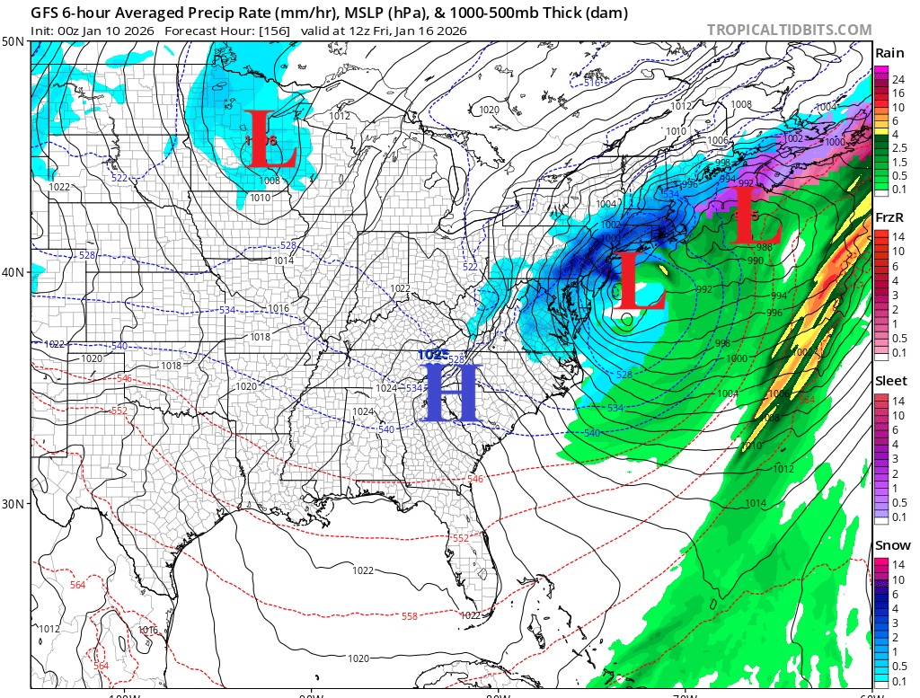
Computer forecast models are becoming better aligned on the idea that a significant winter storm will come together and impact portions of the Mid Atlantic and Northeast later this week. With the threat of a winter storm growing, the National Weather Service is carefully reviewing computer model forecast data, ground, air, and satellite based observations, and climatological trends to understand the threat. Winter Storm Watches or Warnings may be required in the coming days.

Some guidance, like this American GFS computer model output, suggests widespread 6"+ snows across the Mid Atlantic and Northeast with many areas seeing more than 12". Image: tropicaltidbits.com
Some guidance, like this American GFS computer model output, suggests widespread 6″+ snows across the Mid Atlantic and Northeast with many areas seeing more than 12″. Image: tropicaltidbits.com

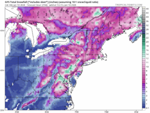
Some computer forecast guidance suggests that a cut-off upper low tracking tracking across the Mid-Atlantic on Thursday will join forces with a secondary surface low cyclogenesis right along the Mid-Atlantic coast. This scenario would likely bring widespread impacts along the I-95 corridor from Washington, DC all the way to Boston, MA.  But the computer forecast guidance isn’t entirely aligned. Some other forecast models are less amplified and aggressive with the trough, simply swinging the base of the trough off the coast with any secondary low development shunted well out into the western Atlantic. If that were to happen, there would be much less, if any, impacts to the Northeast.

The National Weather Service office in Philadelphia wrote in today’s Forecast Discussion, “Ensemble guidance though, does support secondary coastal low development, so this system will need to be closely watched over the coming days to see how close this system may be to our coast.”

Currently, forecast models are suggesting this system could develop next Thursday and/or Friday.

Primary Sidebar

Sponsored Ad

Search

Latest News

  • Blizzard Conditions Expected in Hawaii; Winter Storm Watch Issued; 110 MPH Winds Possible
  • Tornado Watches Expand in Northeast, South
  • Tornadoes Possible Wednesday from Texas to New Jersey
  • USGS Issues Volcano Warning; NWS Issues Ashfall Warning; Highway Closed, Shelter Opened
  • New York City Rattled by Earthquake
  • Very Heavy Snow, Severe Thunderstorms, and Damaging Winds Head to Hawaii
  • Severe Thunderstorm and Tornado Threat Marches East
  • Strong Earthquake Hits Louisiana; State’s Second Largest Quake Ever
About | Careers | Contact | Contests
Terms | Privacy | Ad Choices
Weatherboy is a (R) Registered Trademark of isarithm LLC, All Rights Reserved.
All content herein is Copyright by Isarithm LLC 1997-2022

Insert/edit link

Enter the destination URL

Or link to existing content

    No search term specified. Showing recent items. Search or use up and down arrow keys to select an item.