A powerful storm system known as a Kona Low will continue to impact Hawaii for the balance of the week and into the weekend; but beyond flooding rains and damaging wind gusts, the system is also forecast to produce heavy snow and blizzard conditions on the highest terrain of the state’s island chain on the Big Island of Hawaii. Because of this threat, a Winter Storm Watch has been issued there.
A complex and large upper low set up across the Central Pacific basin combined with smaller short wave troughs which are rotating counterclockwise around this larger central low is sending copious amount of moisture over the Aloha State. Known as a Kona Low, these atmospheric ingredients will combine to produce flooding heavy rains, severe thunderstorms with isolated tornadoes, waterspouts, and hail, damaging wind gusts, and very heavy snow.
The Kona Low gets its name from the change in wind direction that occurs when such a storm moves over the Hawaii Islands. Hawaii is dominated by the trade winds that typically blow in from the northeast. However, the counter-clockwise flow around a Kona low located west of Hawaii results in southwesterly winds over the islands, which is typically the leeward or “Kona” side. Kona Lows are most common between October and April. These type of storms draw abundant moisture up from the warm tropical waters that surround Hawaii; when this moist flow interacts with the steep topography of the island which helps to wring-out moisture, extremely heavy precipitation can fall. Because the wind flow around a Kona Low is atypical, flooding rains occur in places that may not ordinarily flood in tropical downpours that impact the islands from time to time.

A brief respite in the flooding and thunderstorm threats last night will change later today as another weak, negatively tilted, short wave trough moves over the islands from the late morning through the afternoon hours. The Honolulu National Weather Service office on the Hawaiian island of Oahu says the negative tilt on this upper trough will produce more efficient atmospheric lifting dynamics, leading to heavier showers and higher potential for strong thunderstorm activity. Increasing trends in moderate to heavy showers and thunderstorms will continue into the overnight hours as a stronger negatively tilted short wave trough moves into the islands.
The threat for Flash Flooding will continue into the weekend due to both saturated soil conditions that more easily lead to ground runoff and flooding from even more moderate continuous rainfall rates. The highest flood threats across the state will favor southern and western slopes of all islands. These are typically the drier sides of the islands, less accustomed to heavy rain and flooding.
“Driving under these heavy shower bands will become challenging with ponding of water on area roadways,” says the National Weather Service
A Flood Watch continues for all Hawaiian Islands into Saturday and this Flood Watch may need to be extended in time as the heavy rainfall threat may linger into Sunday.
The National Weather Service warns that by Friday, the weather conditions will become vastly more severe. Stronger southwesterly winds providing damaging wind gusts along island mountain slopes are expected, favoring northern and eastern slopes of steep mountain terrain.
“Already saturated ground conditions and trees unaccustomed to southwest winds will fall and likely cause blocked roadways and lead to power outages,” the National Weather Service says. These strong southwesterly winds will continue through Saturday afternoon. These stronger southwest winds speed up into the 50 to 70 mph range around the 5,000 foot level.
These strong winds will also converge at the lower levels, lifting the atmosphere and producing strong convective heavy shower and thunderstorm bands. As these clouds reach higher and higher heights in the atmosphere they will reach up and pull down these stronger winds to the surface, yielding wind gusts in the 50 to 70 mph range in the strongest thunderstorm cells. This means even outside of terrain enhancing wind gusts, any strong thunderstorms are capable of producing severe hurricane force wind gusts over islands or coastal waters through Saturday. Due to this severe wind threat, the National Weather Service has issued a High Wind Watch.
Some of these stronger thunderstorms will likely become severe with the heaviest rainfall rates and strong damaging winds. High levels of instability, wind shear and atmospheric forcing ingredients are all coming into focus over the islands from Friday through Saturday for a potential severe weather event.
Due to the severity possibility, a rare Severe Thunderstorm Watch may be needed during the Friday through Saturday time period. The National Weather Service said, “We will likely wait until we see these severe thunderstorm developing over the local area before pulling the trigger on this Severe Thunderstorm Watch with a short lead time measured in hours.”
From Saturday night to Sunday another upper level short wave trough passes over the islands leading to another upward pulse in moderate to heavy shower activity. Thunderstorms will also threaten the islands and become more of a flooding threat as decreasing upper level and surface wind speeds diminish the damaging wind gust threats.
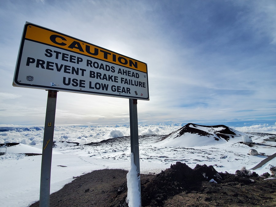
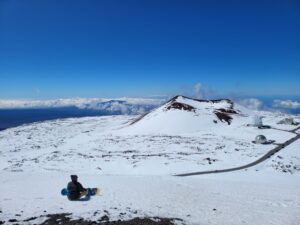
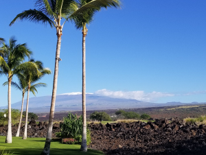
While heavy rain floods lower elevations, the higher terrain of the Big Island will see very heavy snow. While most people don’t associate the tropical paradise Hawaii is known for with snow, they’re surprised to learn that it does snow in the winter due to the elevation of its volcanic peaks. Mauna Kea is the highest of the bunch at 13,803 feet. Maui’s Haleakala is much lower at 10,023 feet. Because of that difference, Hawaii Island will see snow more frequently than the lower peak of Maui Island. Just one storm in January 2020 dropped 2-3 feet of snow on Hawaii Island and created snow drifts that were far deeper. Another storm in 2021 brought snowboarders and skiers out to the mountain by the dozens.
The National Weather Service has issued a Winter Storm Watch for the Big Island summits for elevations 12,000 feet and higher. Here, blizzard conditions are possible with winds gusting as high as 110 mph. Heavy snow accumulations of a foot to a foot and a half of snow are expected, but greater than hurricane force winds will create snow drifts that could be measured in yards rather than feet. The Winter Storm Watch is in effect from this evening through to Saturday afternoon.
Conditions in Hawaii will gradually improve next week. By Monday and Tuesday, the large storm system will begins to lift northward, drifting slowly away from the Hawaiian Islands. This means wet weather will continue but the moderate to heavy rainfall rates will decrease and southwest winds will gradually weaken through the first half of next week. By Wednesday, the latest long range guidance shows a high pressure system building back into position just north of the island chain, allowing a return to a typical trade wind weather pattern with more typical brief passing showers over windward mountain areas.
