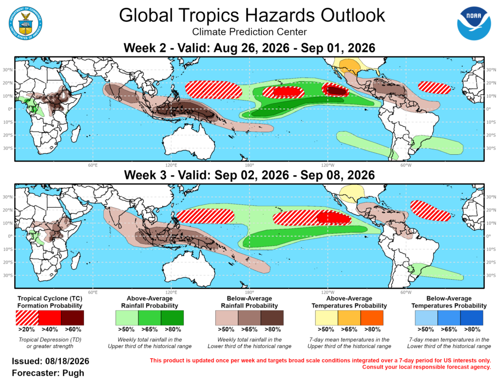
NOAA’s Climate Prediction Center (CPC) released a new Global Tropics Hazards Outlook valid for the next few weeks which shows continued elevated risks in the Central and Eastern Pacific hurricane basins which is exceptionally concerning for Hawaii, which is dealing with the aftermath of Hurricane Lala. In the short term, there is also risk; the Central Pacific Hurricane Center (CPHC)/ National Hurricane Center (NHC) are tracking two disturbances that are expected to develop into tropical cyclones in the coming days, and one could strike places hit hard by Lala in recent days as soon as early next week.
In their latest outlook, the CPC brings attention to El Nino and the Madden-Julian Oscillation, or MJO for short. Both play a significant role in allowing tropical cyclones to form around the world. The term “tropical cyclone” is a broad term used to describe a type of tropical system that usually forms over warm sea surface conditions with ample atmospheric support; tropical storms and hurricanes are examples of tropical cyclones.
ENSO, short for El Nino Southern Oscillation, is a recurring climate pattern involving changes in the temperature of waters in the central and eastern tropical Pacific Ocean. On periods ranging from about three to seven years, the surface waters across a large swath of the tropical Pacific Ocean warm or cool by anywhere from 1°C to 3°C, compared to normal. This oscillating warming and cooling pattern, referred to as the ENSO cycle, directly affects rainfall distribution in the tropics and can have a strong influence on weather across the United States and other parts of the world. El Niño and La Niña are the extreme phases of the ENSO cycle; between these two phases is a third phase called ENSO-neutral. While this phenomena impacts the entire United States, Hawaii is particularly vulnerable to it since they are surrounded by the tropical Pacific Ocean basin.
The MJO is an eastward moving disturbance of clouds, rainfall, winds, and pressure that traverses the planet in the tropics and returns to its initial starting point in 30 to 60 days, on average. This atmospheric disturbance is distinct from ENSO, which once established, is associated with persistent features that last several seasons or longer over the Pacific Ocean basin. There can be multiple MJO events within a season, and so the MJO is best described as intraseasonal tropical climate variability. The MJO was first discovered in the early 1970s by Dr. Roland Madden and Dr. Paul Julian when they were studying tropical wind and pressure patterns. They often noticed regular oscillations in winds between Singapore and Canton Island in the west central equatorial Pacific.
“The strong El Nino continues to be the major influence on anomalous rainfall and tropical cyclone development throughout the global tropics,” the CPC wrote in the outlook released today.” Although the MJO is being masked by the strong El Nino, …observations indicate a MJO circumnavigating the globe this summer. During mid-August, the MJO began to constructively interfere with the El Nino base state similar to what happened about a month ago. Based on dynamical model forecasts, the MJO is expected to propagate eastward over the Western Hemisphere during late August and shift back to the western Indian Ocean by early September.
The strong El Nino, a Western Hemisphere MJO, and climatology are likely to result in an active East Pacific with multiple tropical cyclones expected to form through the beginning of September.

The National Hurricane Center (NHC) is currently monitoring two areas for tropical cyclone genesis through the next week.
While Hurricane Lala is now a category 3 hurricane with 125 mph winds, it is moving away from the state of Hawaii and no longer poses any threat to the islands. However, the same may not be true for at least one of these developing tropical systems in the Pacific.
The closest area of concern to Hawaii is currently a tropical wave located well to the east-southeast of the Big Island of Hawaii; it continues to produce disorganized showers and thunderstorms. According to the NHC and CPHC, environmental conditions appear conducive for gradual development of this system, and a tropical depression is likely to form towards the end of the week or over the weekend while the system moves generally westward across the western portion of the east Pacific and into the Central Pacific. The NHC says there’s a 40% chance that a tropical cyclone will develop here over the next 48 hours and boosts those odds to 70% for formation over the next 7 days.
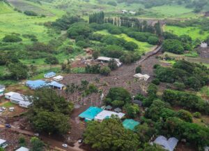
Many, although not all, computer forecast models suggest this new system would approach Hawaii early next week, perhaps as a named tropical cyclone. It’s possible flooding rains and gusty winds could lash the area hit hard by Lala. People in Hawaii need to closely monitor the weather forecast and replenish supplies should another storm hit.
A second disturbance is much farther out and it is too soon to know whether or not this system will ever have any impacts on Hawaii. An area of low pressure is forecast to form several hundred miles south-southwest of the coast of southern Mexico around the end of the week. According to the NHC, gradual development of this system is likely thereafter, and a tropical depression is expected to form this weekend while the system moves generally west-northwestward, remaining well offshore of Mexico. While tropical cyclone formation isn’t expected over the next 48 hours, the NHC says there’s a high 80% chance of formation over the next 7 days.
Beyond the next week, the factors noted previously along with dynamical model support result in a > 60% chance of tropical cyclone development across the East Pacific (10-15N/105-120W) with a 40-60% chance closer to the Central Pacific (140-160W). For the following week, September 2-8, the large-scale environment should remain favorable for another tropical cyclone to form somewhere in the Central to East Pacific with the greatest chance (40-60%) from 105-125W. Given the uncertainty on exact genesis location, a broad 20-40% chance extends as far west as 160W.
“The MJO would tend to favor a less active West Pacific, but model guidance supports a large 20 to 40% chance of tropical cyclone development for this region throughout the outlook period (Aug 26-Sep 8),” the CPC says.
