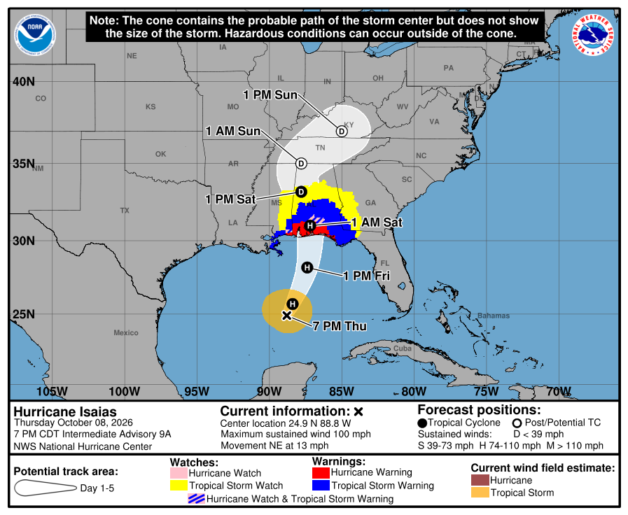
The National Hurricane Center is urging people to rush their plans to protect life and property along the Gulf of America coast ahead of Hurricane Isaias arrival expected late tomorrow or early Saturday. The hurricane has intensified to a 100 mph storm and is heading for the Gulf Coast where Storm Surge Warnings and Hurricane Warnings are in effect.
According to the latest advisory from the National Hurricane Center, Isaias was located about 225 miles north-northeast of Progreso, Mexico and about 290 miles south of the Mouth of the Mississippi River. The storm is moving northeast at 13 mph while the minimum central pressure is down to 974 mb or 28.77″.
A Storm Surge Warning is in effect for the area from the Mouth of the Mississippi River to the Suwannee River and a Hurricane Warning is in effect for the area from Ocean Springs, Mississippi to the Bay/Gulf County Line in Florida. A Tropical Storm Warning is in effect for the Jefferson/Plaquemines Parish Line, Louisiana to west of Ocean Springs, Missippi, and for the area east of Bay/Gulf County Line to Aucilla River, Florida. A Storm Surge Watch is also up for the area between the Suwannee River to Yankeetown, Florida.
A Storm Surge Warning means there is a danger of life-threatening inundation, from rising water moving inland from the coastline, during the next 36 hours in the indicated locations.
A Hurricane Warning means that hurricane conditions are expected somewhere within the warning area, in this case within 24 to 36 hours.
A Tropical Storm Warning means that tropical storm conditions are expected somewhere within the warning area within 36 hours.
A Storm Surge Watch means there is a possibility of life-threatening inundation, from rising water moving inland from the coastline, in the indicated locations during the next 48 hours.
Isaias is moving toward the northeast near 13 mph now. According to the National Hurricane Center, a turn toward the north is expected on Friday. On the forecast track, Isaias is expected to approach the U.S. northern Gulf Coast on Friday and make landfall within the warning area late Friday or early Saturday.
Maximum sustained winds are near 100 mph with higher gusts. Additional strengthening is expected through early Friday. Isaias should remain a dangerous hurricane as it approaches the northern Gulf Coast Friday night.
Hurricane-force winds extend outward up to 15 miles from the center and tropical-storm-force winds extend outward up to 125 miles.
The National Hurricane Center is sharing these 4 key messages:
- A life-threatening storm surge is expected from the Mouth of the Mississippi River to Suwannee, Florida. Residents in the warning area should follow advice given by local officials and evacuate immediately if told to do so.
- Damaging hurricane force-winds are expected over portions of the Florida Panhandle, southern Alabama, and southern Mississippi where a Hurricane Warning is in effect. Residents in these areas should prepare for the possibility of long-duration power outages.
- Damaging wind gusts are possible over much of central and northern Alabama, extreme eastern Mississippi, and portions of western and northern Georgia, especially in areas of higher terrain. Additional Tropical Storm and High Wind Watches and Warnings may be required for portions of that area later tonight. Residents should secure loose outdoor items, avoid driving high-profile vehicles, and prepare for power outages.
- Isaias will bring areas of heavy rainfall to the central U.S. Gulf coast and much of the Southeast Friday into the weekend. Considerable flash and urban flooding, along with significant river flooding, will be possible.
