
Tropical Storm Edouard struck the Louisiana coast yesterday but is bringing catastrophic flooding to portions of eastern Texas where more than 20″ of rain has fallen. The flooding was significant enough to trigger a Flash Flood Emergency for the area this morning, a rare alert issued by the National Weather Service in crisis situations.
According to the National Hurricane Center, Edouard made landfall near Johnson Bayou, Louisiana at 2:20 pm yesterday. The storm had maximum sustained winds estimated to be 60 mph. At the time of landfall, National Ocean Service station near Texas Point, Texas reported a sustained wind of 57 mph and a wind gust to 71 mph.
The storm system has slowly moved up into southeastern Texas, bringing soaking rains in its path.
According to the National Weather Service office in Lake Charles, Louisiana, doppler radar and automated rain gauges indicated thunderstorms associated with Edouard producing heavy rain, with reports of 5 to 20″ of rain reported in Tyler and Hardin Counties. That National Weather Service office said additional rainfall amounts of 1 to 3 inches are possible where flash flooding is already occurring.
TXDOT also reports flash flooding over US 59 near Seven Oaks and Moscow in eastern Texas. There, between 4 and 16 inches of rain have fallen. Additional rainfall is expected this afternoon and evening.
As of the latest update from the National Weather Service’s Weather Prediction Center (WPC) which took over issuing updates from the NHC once Edouard moved inland, the center of the storm was located about 125 miles northwest of Beaumont, Texas and about 40 miles west-northwest of Lufkin, Texas. Maximum sustained winds are at 35 mph while the minimum central pressure was 1004 mb or 29.65″.
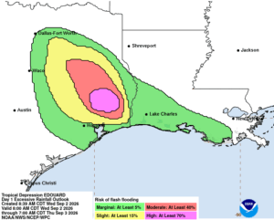
The system, now as a weaker tropical depression, is moving toward the north-northwest near 5 mph and this motion is expected to continue over the next 12 to 18 hours. Gradual weakening of Edouard is expected over the next 12 to 18 hours.
According to the WPC, more wind and rain is likely. Wind gusts of 35 to 45 mph may continue near the center of Edouard for the next several hours. Total rainfall along the path of Edouard is expected to range from 5 to 10 inches, with maximum totals up to 22 inches for
inland areas away from the Upper Texas Coast through east-central Texas.
This rainfall is likely to produce additional flash flooding, especially in low-lying and urban areas. Significant flash flooding is increasingly likely over the Piney Woods area of southeast Texas. River flooding may also be possible. Across Southwest Louisiana, total rainfall will be less, ranging from 2-4″.
