A catastrophe is expected to hit the state of Hawaii yet again as the third tropical cyclone of the season is expected to bring impacts of epic rain and high winds to at least eastern portions of the state. Tropical Storm Nolo developed earlier today and continues to gain strength; the National Hurricane Center expects it to grow into a hurricane soon and a major hurricane by the weekend. The storm is expected to bring significant impacts to the islands of Maui and the Big Island of Hawaii, especially in areas hit hard just weeks ago by Hurricane Lala.
Hawaii Governor Green Governor Green has submitted a request for a federal emergency declaration covering all four counties of the state. The official Pre-Landfall Presidential Emergency Declaration request seeks federal support for debris removal, emergency protective measures and direct federal assistance, including search and rescue, emergency power and electrical-grid support, debris clearance, temporary access, communications, transportation and other critical logistics, at a 75% federal cost share.
“We are closing offices and schools on Hawaiʻi Island starting Thursday to give families time to prepare — and we are expanding those closures to Maui County on Friday as Nolo moves further along its projected track,” said Governor Green. “The safety of our people must come first. Please complete your preparations, avoid unnecessary travel and follow all instructions from emergency officials.”
As of the latest advisory from the National Hurricane Center, Nolo was about 295 miles south of South Point, Hawaii and about 475 miles south-southeast of Honolulu, Hawaii on the island of Oahu.
The storm has maximum sustained winds of 45 mph while minimum central pressure is down to 1002 mb or 29.59″.
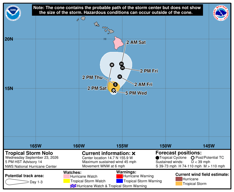
A Hurricane Watch is in effect for all of Hawaii County also known as Hawaii Island or “The Big Island of Hawaii.” A Hurricane Watch means that hurricane conditions are possible within the watch area. A watch is typically issued 48 hours before the anticipated first occurrence of tropical-storm-force winds, conditions that make outside preparations difficult or dangerous.
The National Hurricane Center cautions, “Interests elsewhere in the Hawaiian Islands should closely monitor
the progress of this system.”
Nolo is moving toward the west-northwest near 6 mph for now. According to the National Hurricane Center (NHC), a sharp turn to the north and north-northeast is expected late tonight, with this motion continuing through the end of the week. On the forecast track, the system is expected to approach the Big Island of Hawaii on Friday and Saturday.
Maximum sustained winds are near 45 mph with higher gusts. Nolo is forecast to become a hurricane by Thursday night and could become a major hurricane by the weekend with maximum sustained winds in excess of 115 mph near its core. Tropical-storm-force winds extend outward up to 80 miles from the center and the storm is expected to grow in size over the coming days.
Hurricane conditions are possible in the watch area on Hawaii starting as early as Friday night. Damaging wind gusts could topple trees and knock down electrical and telephone lines, both of which may be out for a prolonged period of time.
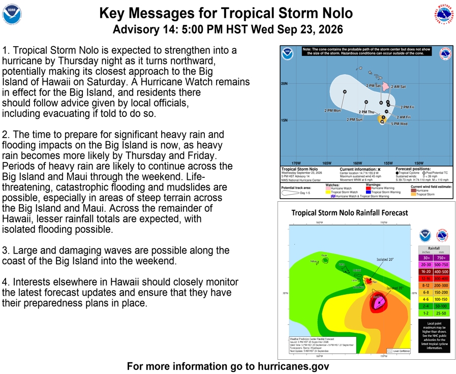
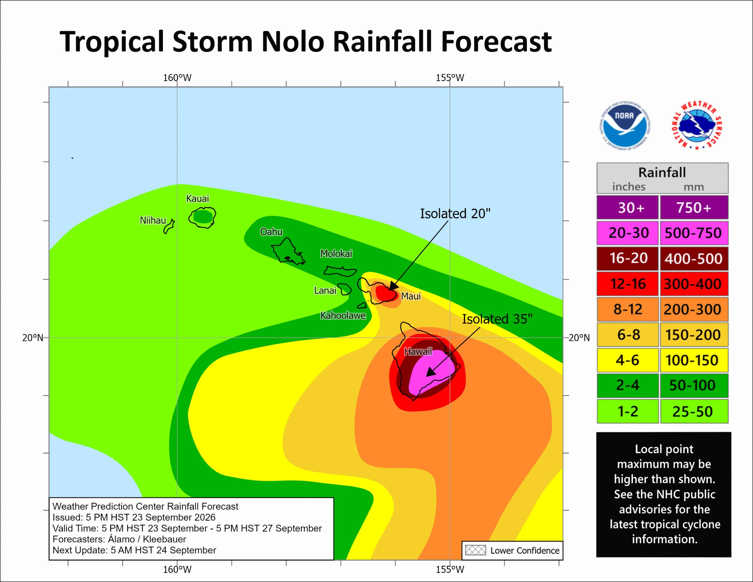
But the bigger story with Nolo will be the epic rain expected due to its slow-moving speed. Tropical Storm Nolo will produce rainfall totals of 15-20″ across the Big Island with maximum amounts of 35″. This rainfall may produce catastrophic life-threatening flooding and mudslides, especially in areas of steep terrain. Rainfall totals of 5-10″ with maximum amounts of 20″ are expected across Maui. Across the remainder of the Hawaiian Islands, rainfall totals of 1-3″ with maximum amounts of 6″ expected with isolated flooding possible.
The combination of a dangerous storm surge and the tide will cause normally dry areas near the coast to be flooded by rising waters moving inland from the shoreline. The water could reach 1-3 feet heights above ground if the peak surge occurs at the time of high tide. The deepest water will occur along the immediate coast near and to the right of the landfall location, where the surge will be accompanied by large and dangerous waves. Surge-related flooding depends on the relative timing of the surge and the tidal cycle, and can vary greatly over short distances.
Swells generated by Nolo are expected to reach exposed east and south-facing shores of the Big Island by Friday, spreading westward and building through the weekend. These swells are likely to cause life-threatening surf and rip current conditions.
As the storm approaches the state, there is also a risk of isolated tornadoes and water spouts.
