A slow-moving storm dumped more than 5 inches of rain on parts of southeastern Massachusetts on Friday and early Saturday, flooding streets from Cape Cod to New Bedford, washing out roads and sending water into businesses and a police station.
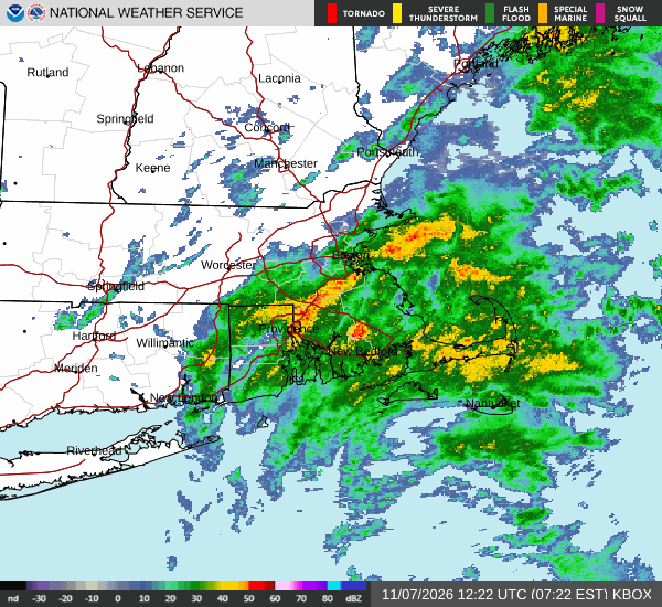
Preliminary reports compiled by the National Weather Service office in Norton showed the heaviest totals along the South Coast and the upper Cape. A gauge 4 miles southeast of Westport recorded 5.68 inches by 6:25 a.m. EST Saturday, a site 3 miles northwest of Rochester measured 5.58 inches and a station 3 miles southwest of Mashpee reported 5.55 inches. Marion, Wareham and East Falmouth also reported totals near or above 5 inches.
The weather service said the reports came from a mix of airport sensors, volunteer observers and private networks and that “not all data listed are considered official.”
A sensor near New Bedford Regional Airport recorded 4.87 inches, the Hyannis airport recorded 3.47 inches and Boston’s Logan International Airport recorded 3.12 inches, according to the weather service. In Rhode Island, T.F. Green International Airport in Warwick measured 2.97 inches, while observers near Hopkinton and Jamestown reported more than 4 inches.
Cape Cod Takes the Brunt
The flooding was most visible on Cape Cod, where thunderstorms moved through Friday morning and early afternoon before steadier rain settled in.
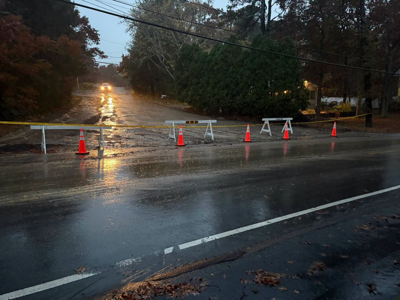
Falmouth police said multiple roads were flooded, including the area in front of the Bank of America near Falmouth Lumber, Falmouth Heights Road, Grand Avenue and Menauhant Road, and urged drivers not to attempt to drive through floodwater.
The weather service issued a flood warning for southwestern Barnstable County on Friday afternoon. At 1:53 p.m. EST, the agency said radar and automated rain gauges showed that 2 to 3 inches of rain had fallen, with 1 to 2 more inches possible. The warning listed Barnstable, Falmouth, Yarmouth, Sandwich, Bourne, Mashpee and Hyannis among the places that could flood.
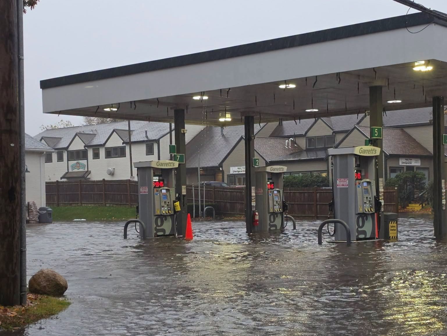
At Garrett’s Family Market and gas station off Route 28 in Falmouth, water rose to about knee level and trash barrels floated around the gas pumps, Boston 25 News reported. Employee Erin Crossley told the station that the business had to close for a few hours.
“We had to close the store for a few hours because the flooding was up to a little bit past knee level,” Crossley said. “No cars could get in or out, and it was actually coming in the front of the store as well.”
Crossley said fallen leaves were clogging storm drains, worsening the problem. The weather service had warned in its flood watch that storm drains and ditches could become clogged with debris.
Falmouth police said water also got inside the police station, according to Boston 25 News. WHDH-TV reported that the department ordered evening-shift officers to report early to handle the volume of weather-related calls.
Hailey Ducharme, who works at a nearby hardware store, told WHDH that she arrived to “complete chaos.”
“Outside, someone’s car was almost completely submerged in water,” Ducharme said.
Elsewhere on the Cape, Provincetown police said Winslow Street was washed out and limited to resident access, according to Cape Wide News. Bourne police said Eldridge Street was closed to through traffic between Colony Avenue and Clay Pond Road because of “washout from the heavy rains,” and said they expected it to reopen Saturday.
Cape Wide News also reported that a motorist had to be rescued Friday evening after becoming stranded in deep water on Old Main Road under the train bridge in Bourne.
The storm also caused power problems. Cape Wide News reported that more than 1,100 Eversource customers lost power in Truro on Friday afternoon and that firefighters responded to reports of explosions at a power substation on Shore Road. Harwich police closed Orleans Road, also known as Route 39, between Freshwater and Bucks Pond because of a broken utility pole, the outlet reported.
Late-Night Flash Flooding on the South Coast
A second round of heavy rain Friday night pushed water into streets around New Bedford and Acushnet.
The weather service issued a flash flood warning for southeastern Bristol and southern Plymouth counties after law enforcement reported road closures. At 9:14 p.m. EST, the agency said 1.5 to 2.5 inches of rain had fallen in the warned area, with 1 to 2.5 more inches possible. The warning was allowed to expire at 11:30 p.m. after the heaviest rain ended, but the weather service told residents to continue to heed road closures.
New Bedford police said “significant flooding” was affecting city streets and that the New Bedford-Fairhaven Bridge was temporarily closed because its gates malfunctioned, WJAR-TV reported. Several cars became stuck in floodwater in the city, the station said.
“Please avoid unnecessary travel and never drive through flooded streets,” police said in a post on X, according to WJAR.
Street flooding was also reported in Somerset and on Oaklawn Avenue in Cranston, Rhode Island, which the station described as a common trouble spot.
In Brockton, Westgate Drive flooded, blocking access to businesses, WHDH reported. Dave Halter, manager of a Salvation Army Family Store on the street, said the closures have a familiar effect.
“Once this happens, we’re pretty much shut down unless people walk and find their way through the water,” Halter said.
What Caused the Soaking
The rain came from broad low pressure along a front that stalled across eastern Massachusetts and Rhode Island, the weather service said. Repeated rounds of rain and thunderstorms moving over the same areas allowed totals to climb quickly, especially near the South Coast.
The NOAA Weather Prediction Center had placed parts of southern New England under a slight risk, level 2 of 4, of excessive rainfall, warning that urban areas, roads, small streams and low-lying areas were the most vulnerable to localized flash flooding.
Before the storm, NBC10 Boston had forecast widespread 1 to 3 inches of rain, with local amounts of 4 to 5 inches where the heaviest band set up, amid temperatures the station described as unusually mild for early November. Observed totals in several South Coast and Cape Cod communities exceeded that range.
What Comes Next
The weather service said in its Saturday morning forecast discussion that widespread rain should move offshore by Saturday afternoon as the low pulls away toward Downeast Maine and Nova Scotia. A flood watch covering Rhode Island and Barnstable, Bristol, Dukes and Plymouth counties in Massachusetts was scheduled to expire at 10 a.m. EST Saturday.
A strong disturbance passing overhead could still produce lighter showers Saturday afternoon and night, mainly over northern Massachusetts, forecasters said. NBC10 Boston said some showers could bring brief downpours and small hail.
Cooler and drier air is expected to arrive next week, with highs mostly in the 50s to low 60s and overnight lows in the 30s and low 40s, the weather service said. Breezy westerly winds are expected Monday and Tuesday. Forecasters said another low-pressure system could bring unsettled weather back to the region late next week, though details remained uncertain.
When it let the New Bedford-area flash flood warning expire late Friday, the weather service told residents to keep heeding road closures that remained in place. The agency’s flood warnings carried a familiar message for drivers: “Turn around, don’t drown when encountering flooded roads. Most flood deaths occur in vehicles.”
