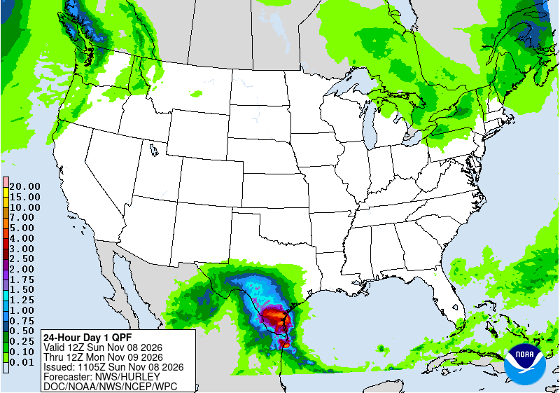
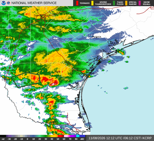
Heavy thunderstorms dropped 1 to 3 inches of rain on parts of Webb and Duval counties early Sunday, prompting the first flash flood warning of a multiday South Texas rain event, and forecasters said a second, possibly heavier round would arrive Sunday night.
The National Weather Service in Corpus Christi issued the flash flood warning at 5:04 a.m. CST for southwestern Duval County and southeastern Webb County, valid until 8 a.m. Doppler radar and automated rain gauges indicated thunderstorms producing heavy rain across the area, with 2 to 4 more inches possible, the warning said.
“Flash flooding is ongoing or expected to begin shortly,” the weather service said.
The warning named Oilton, Mirando City, Bruni, Aguilares and Ranchitos Las Lomas as places that would experience flash flooding. It also covered U.S. Highway 59 between mile markers 790 and 816, the highway that runs east from Laredo toward Freer.
The warning fell inside flood watches that were already in effect Saturday. Sunday’s updates kept those watches in place and pointed to more rounds of storms before the rain winds down Monday night.

Watches Already in Place, Now Widened
The Corpus Christi office first issued its flood watch at 8:17 p.m. CST Friday, Nov. 6, for a broad area from La Salle and McMullen counties to the Coastal Bend. In a 12:34 a.m. update Sunday, the office said the watch remains in effect through Monday morning for La Salle, McMullen, Live Oak, Bee, Goliad, Webb, Duval, Jim Wells, Kleberg, Nueces, San Patricio, Aransas and Refugio counties, including the barrier islands.
The watch covers Laredo, Corpus Christi, Kingsville, Alice, Beeville, Rockport, Cotulla, Port Aransas and dozens of smaller towns.
“Widespread forecast rainfall amounts of 2-5 inches will be common across South Texas,” the update said. “Isolated amounts of 7 to 9 inches remains a possibility, especially in the vicinity of training and slow moving storms.”
Forecasters said the ground could absorb much of that water, but they warned that intense downpours could overwhelm it in spots. “While soils will be able to absorb most of this moisture, the higher rainfall rates, slow storm motion, and training can quickly lead to localized, urban flooding and in locations with poor drainage,” the watch said.
Farther south, the weather service office in Brownsville first issued its flood watch at 11:34 a.m. CST Saturday for Zapata, Jim Hogg and Brooks counties. At 9:50 p.m. Saturday, it added Starr County, including Roma and Rio Grande City.
The Brownsville office’s 5:24 a.m. update Sunday said the watch remains in effect through Monday morning. It said there is potential for heavy rainfall, “including two windows where rainfall rates could reach 2 inches per hour for two hours.” The first window was late Saturday night into early Sunday morning, and the second is Sunday night through mid-morning Monday.
What is Driving the Rain
A slow-moving upper-level low over northern Mexico is the main driver, forecasters said. In its early Sunday discussion, the Corpus Christi office said the system is slowing down and placing all of South Texas under favorable lifting aloft through Monday night as it begins to weaken.
At the surface, a boundary west of Alice is funneling Gulf moisture into South Texas, the office said. A low-level jet is adding more moisture, and the office said precipitable water values above 1.7 inches were already moving into the region.
“Given all these factors, in addition to elevated instability and some slantwise/CSI instability, we’re in for a soggy 24-36 hr period across South Texas,” the discussion said.
The office said the latest forecast calls for 2 to 4 inches along the coast from Rockport southwest, and 3 to 6 inches in the Brush Country through Monday night. It said the heaviest totals, 7 to 9 inches, are most likely where storms move slowly or repeatedly track over the same area. National Blend of Models guidance shows much of Webb County with a 20% to 40% chance of topping 6 inches, the discussion said.
Heavy rates and training storms “will increase the risk for flash flooding, especially as these storms move into the more urbanized areas across South Texas (such as Laredo, Alice, Kingsville, Corpus Christi, etc),” forecasters wrote.
The Brownsville office forecast 1 to 3 inches in its area Sunday, with isolated pockets of 4 to 5 inches in western counties, and another 1 to 3 inches Monday, heaviest along and west of Interstate 69C.
National Forecasters Eye an Upgrade
The Weather Prediction Center in College Park, Maryland, kept a slight risk of excessive rainfall across south-central and South Texas in its 3:12 a.m. EST outlook Sunday. The center said the highest threat lies in the area from Webb County toward Corpus Christi.
High-resolution models show a complex of storms moving from eastern Webb County toward Corpus Christi by afternoon, with storms firing again over Deep South Texas Sunday night, the center said.
A blend of ensemble guidance showed a widespread 3 to 6 inches, “with as much as 8″ occurring during the full period,” the center said. Rain rates should generally top out at 1 to 2 inches per hour, it said.
The center said that area has a better than normal chance for flash flooding because of the long duration of the storms overhead. It said a targeted upgrade is possible depending on observed rainfall and flood reports.
The Storm Prediction Center forecast no severe thunderstorm risk areas Sunday, citing “considerable uncertainty” about whether clouds and rain from early storms would keep the air too stable.
Rain Falls on a Dry Fall
The rain is arriving after a dry stretch. Laredo had received 1.51 inches of rain since Sept. 1 through Saturday, 4.19 inches below normal, according to the weather service’s daily climate report. Corpus Christi had 6.20 inches over that period, 2.93 inches below normal.
The Brownsville office called the rain “beneficial” for most of the Rio Grande Valley, but it said the potential for isolated flash floods continues through Monday morning. Its key messages said the northern ranchlands are most at risk, especially Sunday night.
Laredo television station KGNS reported Saturday that rain had begun moving into the area and that the flood watch there would remain in effect until noon Monday.
As of early Sunday, the weather service had not issued any local storm reports of flooding damage or water rescues for the Corpus Christi or Brownsville areas.
Coast Faces Rip Currents and Tidal Flooding
The storm system is also stirring up the coast. The Corpus Christi office issued a coastal flood advisory from noon Sunday to 3 a.m. Monday for Gulf-facing beaches and bays. Water levels could reach 2 to 2.5 feet above mean sea level at high tide Sunday and again Monday, forecasters said.
Forecasters warned that vehicles parked on the sand along Nueces Bay could be cut off from dry land. East winds of 20 to 25 knots will create a high rip current risk, and a small craft advisory is in effect through Sunday night, with seas building to 6 to 8 feet.
The Brownsville office forecast a high risk of rip currents from noon Sunday through Monday afternoon along the lower Texas coast.
What Comes Next
Rain is expected to taper Monday night. The Corpus Christi office said rain chances continue Tuesday at 20% to 30% and Wednesday at 20% to 40% near the coast and in the Victoria Crossroads before a front clears the area Thursday.
The weather service urged drivers to avoid flooded roads. “Turn around, don’t drown when encountering flooded roads. Most flood deaths occur in vehicles,” the flash flood warning said. It also urged people to “be especially cautious at night when it is harder to recognize the dangers of flooding.”
