While focus remains on the ongoing catastrophe in Texas with Harvey, eyes on are on east coast storm threat. The National Hurricane Center initiated advisories on the system officially known as Potential Tropical Cyclone #10; it is likely to become a Tropical Storm within the next 24 hours and when that happens, it would be named Irma.
Deep convection has been increasing in both intensity and coverage during the past several hours in association with Potential Tropical Cyclone #10. However, satellite and radar data indicate that the circulation remains poorly defined, therefore, the system is not yet a tropical cyclone. The disturbance is located in weak steering currents, and has been meandering during the last several hours. A continued slow and erratic motion is likely to continue overnight and early Monday. A mid- to upper-level trough currently over the central U.S. is expected to approach the system, and should cause the disturbance to begin moving northeastward by late Monday. A faster east-northeastward to northeastward motion is forecast thereafter when the system becomes embedded in the mid-latitude westerlies.
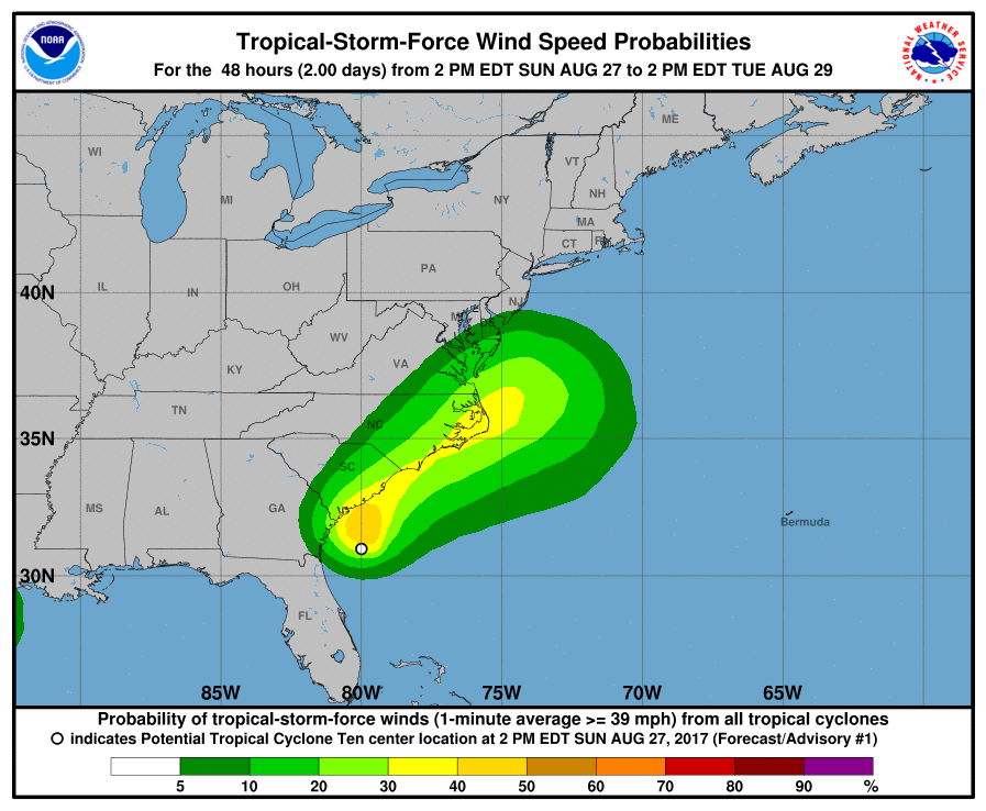
The National Hurricane Center forecast takes the center of the disturbance near the Georgia and South Carolina coasts tonight and Monday and along the North Carolina coastline Monday night and Tuesday.
The elongated center of the disturbance is located to the west of the main area of deep convection due to strong westerly vertical wind shear. The shear is only expected to lessen a little during the next 12 to 24 hours, but it will likely weaken enough to allow
the system to become a tropical cyclone. After that time, increasing shear and interaction with the aforementioned trough should cause the disturbance to lose its tropical characteristics in about 48 hours. Strengthening is likely for a couple of days while the system is post-tropical due to baroclinic effects.
Although the potential for tropical storm winds are within the warning time period (36 hours), given the uncertainty in whether these winds will occur on land in northeastern South Carolina and southeastern North Carolina, a tropical storm watch remains in effect for those areas. The National Hurricane Center continues to point out that for locations north of Duck, North Carolina, local National Weather Service offices in Virginia and New Jersey will handle advisories there.
Experts believe this Atlantic Hurricane Season, which runs through to the end of November, will be a busy one. Dr. Phil Klotzbach and the experts at Colorado State University updated their seasonal outlook again on July 5, showing a much more active than normal season expected. The National Oceanic and Atmospheric Administration (NOAA) also released their own forecast which shows this hurricane season to be likely more active than others.
