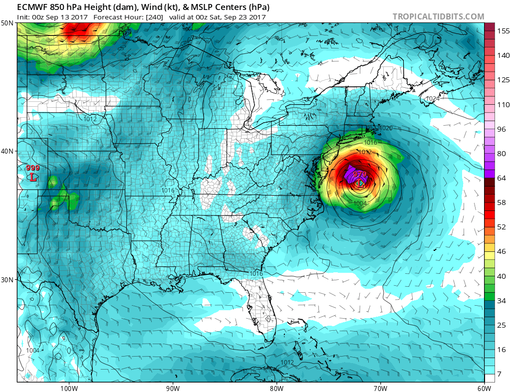
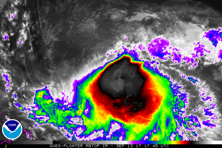
Hurricane Jose continues to spin about north of the Dominican Republic, away from any landmass for now. It is no immediate threat to land and to the US East Coast, but that could change over time. Jose continues to be affected by strong northwesterly shear associated with an upper-level anticyclone centered to its west. Although the hurricane tried to develop some banding features yesterday, the system has again transformed into a rather shapeless mass of intense convection. According to the National Hurricane Center (NHC), dynamical models indicate that strong shear, from varying directions, will persist over Jose for the next several days. Jose will likely be passing over its own cold wake in a couple of days. The NHC says passing over that cold wake and dealing with strong shear are factors that argue against strengthening in the short term.
Jose has been moving slowly southeastward between a mid-level anticyclone to its west and a trough to the northeast. The global models show a high pressure area building to the east- northeast of Jose in a couple of days, which should eventually induce a poleward motion. The track models show a looping motion during the next 48 hours followed by a turn toward the north, as does the official forecast. The latest NHC track is similar to the previous one and lies between the ECMWF solution and the other models, which are farther west. This keeps Jose away from land areas for at least the next several days.
Beyond the next several days, there are concerns with where Jose heads next. Climatologically, most storms located where Jose currently is do curve out to sea; however, some do make their way to the US East Coast. Some global forecast models continue to suggest on some runs that Jose will drift close enough to the US east coast for a landfall somewhere between North Carolina and the Canadian Maritimes, with the Jersey shore a popular point on forecast runs. However, the number of extended forecasts runs suggesting such an outcome have dropped off over the last 24 hours, suggesting that a path out to sea may be more probable.

Nevertheless, extended forecast guidance is poor when it comes to tropical cyclones; this is one reason why the NHC only issues five day forecasts at a time. Even at day five, NHC forecasts can be off when it comes to both intensity and track. Because of that, little weight should be put on forecasts that bring Jose to the East Coast or away from it next week. While climatology suggests a curve out to sea, it is just much too soon to say with any degree of confidence or certainty where Jose will go next week.
While Jose may or may not impact the East Coast next week, it is still important that residents of the East Coast have a Hurricane Action Plan. From Jose or future threats from the tropics, it may become necessary for some to act on those plans before the Atlantic Hurricane Season ends later in November.
Experts believe this Atlantic Hurricane Season, which runs through to the end of November, will be a busy one. Dr. Phil Klotzbach and the experts at Colorado State University updated their seasonal outlook again on July 5, showing a much more active than normal season expected. The National Oceanic and Atmospheric Administration (NOAA) also released their own forecast which shows this hurricane season to be likely more active than others.
