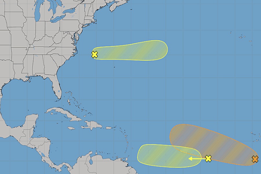
The National Hurricane Center has identified three areas of concern they’re tracking in the Atlantic; while two are unlikely to develop into a tropical cyclone, one could eventually become a tropical storm over time. The Atlantic Hurricane Season runs now through the end of November, with early/mid September usually the peak of the season.
The first area of concern is in the western subtropical Atlantic. A trough of low pressure located a few hundred miles west-northwest of Bermuda is producing disorganized shower and thunderstorm activity. The National Hurricane Center (NHC) says some development of this system is possible during the next couple of days while it moves quickly eastward, well to the north of Bermuda across the western and central subtropical Atlantic. However, the system is forecast to reach cooler waters later this week, ending its chances of formation after Wednesday. The NHC says there’s a low chance, about 10%, that this area will develop into a tropical cyclone.

The second area of concern consists of a broad area of showers and thunderstorms associated with a tropical wave is located about midway between the coast of west Africa coast and the Lesser Antilles. The NHC says that some gradual development of this wave is possible during the early to middle part of this week while it moves quickly westward across the central tropical Atlantic. However, as with the first system, conditions will turn hostile towards formation later in the week; upper-level winds are expected to become less conducive for development when the system approaches the Lesser Antilles. As with the first system, the NHC says there’s only a 10% chance that this disturbance will develop into a tropical cyclone over the next 7 days.
The third and most impressive disturbance is located near the Eastern and Central Tropical Atlantic. A small area of low pressure has formed a few hundred miles south of the Cabo Verde Islands. This system is forecast to move slowly west and merge with a tropical wave in a couple of days, and environmental conditions are forecast to be more conducive for development by midweek.
“A tropical depression could form during the latter half of this week while the system moves westward to west-northwestward across the central tropical Atlantic,” said the NHC today in their latest Tropical Outlook.
The National Hurricane Center says there’s a medium 50% chance of tropical cyclone formation here. If it develops into a tropical depression and strengthens from there, it would earn the name “Cristobal” as the third tropical storm of the season.
The 2026 Atlantic Hurricane Season has yet to produce any hurricanes. Since it began on June 1, the season has only produced two named storms and both were in the Gulf of America: Arthur and Bertha. Experts continue to call for a below-normal season with less hurricanes and tropical storms than normal due to the influence of the El Nino weather phenomena.
