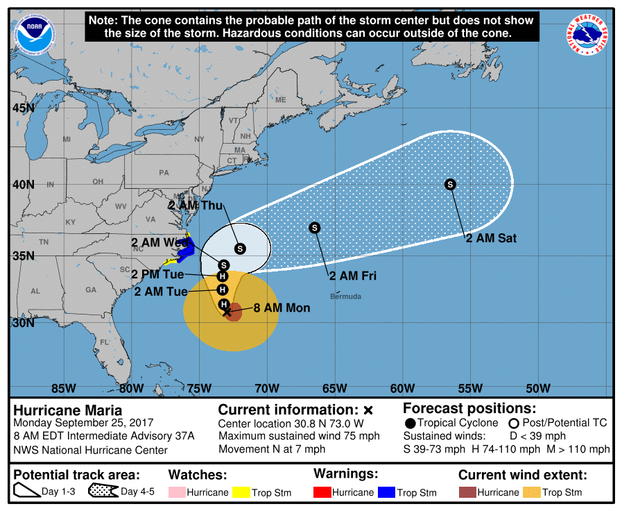
Eyes are on Hurricane Maria today as it approaches the Mid Atlantic. Ahead of possible impacts from the storm, the National Hurricane Center has issued Tropical Storm Warnings and Watches and Storm Surge Watches for portions of the North Carolina Coast. A Tropical Storm Warning is in effect for Cape Lookout to Duck including the Albermarle and Pamlico Sounds; a Tropical Storm Watch is in effect north of Duck to the North Carolina/Virginia border; a Tropical Storm Watch is also up north of Surf City to south of cape Lookout. A Storm Surge Watch is in effect for Cape Lookout to Duck. A Tropical Storm Warning means that tropical storm conditions are expected somewhere within the warning area within 36 hours. A Tropical Storm Watch means that tropical storm conditions are possible within the watch area, in this case within the next 36 to 48 hours. A Storm Surge Watch means there is a possibility of life-threatening inundation, from rising water moving inland from the coastline, in the indicated locations during the next 48 hours.
In this morning’s update from the National Hurricane Center (NHC), Maria was located at 30.8N 73.0W, which puts it roughly 335 miles south south east of Cape Hatteras, North Carolina. Hurricane Maria was a minimal hurricane with maximum sustained winds of 75mph; it is moving to the north at 7mph. Maria is a large hurricane; hurricane-force winds extend outward up to 70 miles mainly to the east of the center and tropical-storm-force winds extend outward up to 230 miles. The latest minimum central pressure reported by an Air Force Reserve Hurricane Hunter aircraft is 961 mb (28.38 inches).
The official forecast from the NHC brings Maria closer to the Outer Banks later tomorrow and Wednesday, with the center remaining well off-shore. The forecast also keeps the center of circulation well off-shore and drives it rapidly off to the east as Maria nears the Outer Banks, weakening to a tropical storm as it does so. Because of this track, hurricane force winds should never approach land and tropical storm force winds will only just brush along the Warning and possibly Watch areas. The precipitation shield associated with the storm should also only graze North Carolina, with conditions remaining dry further up the coast into Maryland, Delaware, and New Jersey and south over southern North Carolina and South Carolina.
While precipitation and wind will be mainly over the ocean, because Maria’s wind field is so large, surf will be kicked up along much of the US East Coast. While Maria will be far from the coast, it will be able to generate a storm surge in northeastern North Carolina; residents and tourists there should be prepared to deal with storm surge flooding, especially at times of high tide. Beyond the coastal flooding threat in the Mid Atlantic, beach erosion and dangerous rip currents will continue to plague the coast from Massachusetts to Florida. Early autumn beach-goers should monitor public statements on beach conditions and remember that many beaches are lifeguard free this time of year; dangerous surf and unattended beaches could be a deadly combination: avoid ocean swimming and surfing.
By Thursday night, Maria, as a Tropical Storm, should continue to accelerate over the open waters of the North Atlantic where it will eventually degenerate. When it does so, it’ll end a chapter of a deadly and costly hurricane in a very active hurricane season.
