• Skip to primary navigation
  • Skip to main content
  • Skip to primary sidebar

Weatherboy

Weatherboy Weather News, Maps, RADAR, Satellite, and Forecasts.

  • Local
  • Earth Science News
  • RADAR
  • Current Warnings
  • Satellite
  • Current Maps
  • Forecast Maps
  • Video

Severe Weather Returns to Pennsylvania, New Jersey, New York

by Weatherboy Team Meteorologist - October 2, 2018

The Storm Prediction Center's Convective Outlook highlights an area where the greatest chance of severe weather is today in yellow. Image: weatherboy.com
The Storm Prediction Center’s Convective Outlook highlights an area where the greatest chance of severe weather is today in yellow. Image: weatherboy.com


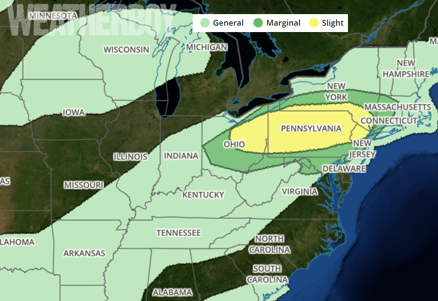
The National Weather Service’s Storm Prediction Center (SPC) is cautioning people to the possibility that severe weather will return to Pennsylvania, New Jersey, and New York this afternoon and evening. The SPC has already issued a Tornado Watch for portions of Pennsylvania due to this threat.

The Storm Prediction Center has identified an area where severe storms are forming and where a watch could be issued today. Image: SPC

According to the SPC, initial convective development is occurring in eastern Ohio and western Pennsylvania. Storm coverage is expected to increase by 4pm local time .

The current visible satellite shows relatively few breaks within the cloud cover across western and central Pennsylvania and eastern Ohio. Areas that have remained relatively clear have heated to the mid- to upper-70s, contributing to atmospheric instability. Areas of cumulus clouds that have developed along and near a confluence axis in eastern Ohio and western Pennsylvania shows that convective inhibition has nearly been eliminated. With the convective inhibition eliminated, the environment is expected to support severe storm development. Large hail and damaging winds are possible with these storms, according to the SPC. They also say a tornado or two are also possible, with the greatest threat of tornadic cells over Pennsylvania.


Tornado Watch in effect in red areas. Image: SPC

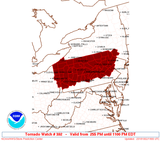
Because of the threat of tornadic cells beyond severe wind and hail, the National Weather Service has issued a Tornado Watch for a portion of Pennsylvania through 11pm tonight. A watch is issued when severe thunderstorms are expected and the threat of tornadic activity is higher than usual.

Primary Sidebar

Sponsored Ad

Search

Latest News

  • Soviet Union Spacecraft Crash Zones Updated; NJ/NY/PA/MI at Increased Risk
  • Over 2,000 People Report Shaking from Virginia Earthquake
  • Morning Earthquake Strikes Heart of New Madrid Seismic Zone in Missouri Today
  • New York TV Weatherman Back After Brain Injury
  • NASA Monitoring Significant Magnetic Anomaly over Atlantic
  • Out of Control Soviet Union Spacecraft Could Crash Into Your House This Week
  • Elevated Tornado Threat in New Jersey, Pennsylvania, and New York
  • Significant Severe Weather Outbreak Likely Today
About | Careers | Contact | Contests
Terms | Privacy | Ad Choices
Weatherboy is a (R) Registered Trademark of isarithm LLC, All Rights Reserved.
All content herein is Copyright by Isarithm LLC 1997-2022