
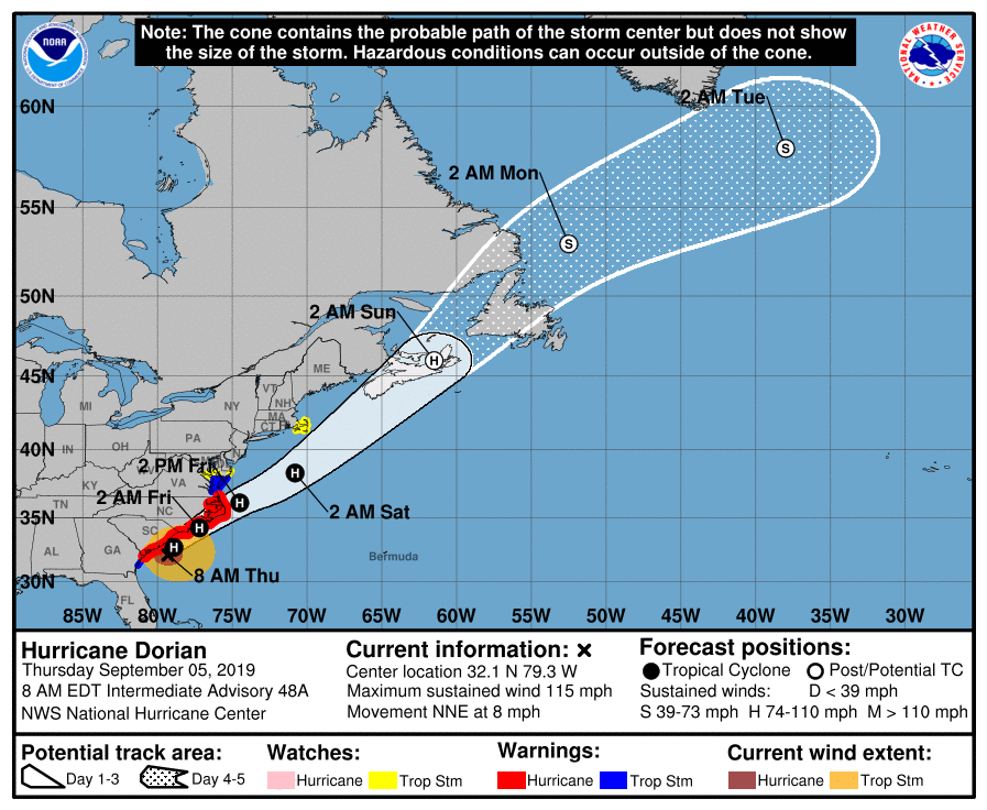
Hurricane Dorian is inching closer and closer to the North Carolina coast today with landfall likely near or just south of the Outer Banks of North Carolina early tomorrow. Even before the eye nears the coast, torrential rains, damaging winds, and numerous tornadoes are impacting portions of the southeast coast. And to make sure people in New England are properly prepared, the National Hurricane Center has issued a Tropical Storm Watch for Woods Hole to Sagamore Beach in Massachusetts; Nantucket and Martha’s Vineyard are also in the watch area.
A large portion of the U.S. East Coast is under advisories tied to Hurricane Dorian. A Storm Surge Warning is now in effect from the Savannah River to Poquoson, Virginia, for the Pamlico and Albemarle Sounds, for the Neuse and Pamlico Rivers, and for Hampton Roads. A Hurricane Warning is in effect for the Savannah River to the North Carolina/Virginia border and the Pamlico and Albemarle Sounds. A Tropical Storm Warning is in effect from the North Carolina/Virginia border to Chincoteague, Virginia and in the Chesapeake Bay from Smith Point southward. Beyond the new watch in New England, a Tropical Storm Watch is in effect from north of Chincoteague , Virginia to Fenwick Island, Delaware, for Chesapeake Bay from Smith Point to Drum Point, and along the tidal Potomac south of Cobb Island.
A Storm Surge Warning means there is a danger of life-threatening inundation, from rising water moving inland from the coastline, during the next 36 hours in the indicated locations. The National Hurricane Center warns, “This is a life-threatening situation. Persons located within these areas should take all necessary actions to protect life and property from rising water and the potential for other dangerous conditions. Promptly follow evacuation and other instructions from local officials.” A Hurricane Warning means that hurricane conditions are expected somewhere within the warning area. Preparations to protect life and property should be rushed to completion. A Tropical Storm Warning means that tropical storm conditions are expected within the warning area within 36 hours. A Tropical Storm Watch means that tropical storm conditions are possible within the watch area, generally within 48 hours.
As of the latest advisory from the National Hurricane Center, the eye of Hurricane Dorian was located near latitude 32.1 North, longitude 79.3 West. Dorian is now moving toward the north-northeast near 8 mph. A turn toward the northeast is anticipated by tonight, and a northeastward motion at a faster forward speed is forecast on Friday. On the forecast track, the center of Dorian will continue to move close to the coast of South Carolina today, and then move near or over the coast of North Carolina tonight and Friday. The center should move to the southeast of extreme southeastern New England Friday night and Saturday morning, and approach Nova Scotia later on Saturday.
Maximum sustained winds are near 115 mph with higher gusts. Dorian is a category 3 hurricane on the Saffir-Simpson
Hurricane Wind Scale. Some fluctuations in intensity are expected this morning, followed by slow weakening through Saturday. However, the National Hurricane Center expects Dorian to remain a hurricane for the next few days.
Hurricane-force winds extend outward up to 60 miles from the center, and tropical-storm-force winds extend outward up to 195 miles. The estimated minimum central pressure based on Air Force Reserve Hurricane Hunter data is 959 mb or 28.32 inches or mercury.
Hurricane Dorian is bringing threats of damaging winds, potentially lethal storm surge, heavy rain, and tornadoes to portions of the east coast. Tropical storm conditions are currently affecting portions of the Georgia and South Carolina coasts. Hurricane conditions are expected along portions of the South Carolina coast later this morning. Tropical storm conditions are spreading along the coast of North Carolina, and hurricane conditions are expected to begin later today. Tropical storm conditions are expected in the Tropical Storm Warning area in the Mid-Atlantic states by Friday, with tropical storm conditions possible in the Tropical Storm Watch area Friday or Friday night. Tropical storm conditions are possible over portions of southeastern Massachusetts by late Friday or early Saturday. The combination of a dangerous storm surge and the tide will cause normally dry areas near the coast to be flooded by rising waters moving inland from the shoreline. The water could reach 5-8′ from Isle of Palms to Myrtle Beach, South Carolina, 4-7′ from Myrtle Beach, South Carolina to Duck, North Carolina including Pamlico and Albemarle Sounds and the Neuse and Pamlico Rivers, 2-4′ from Duck, North Carolina to Poquoson, Virginia, including Hampton Roads and also 2-4′ from the Savannah River to Isle of Palms, South Carolina. Water levels could begin to rise well in advance of the arrival of strong winds. The surge will be accompanied by large and destructive waves. Surge-related flooding depends on the how close the center of Dorian comes to the coast, and can vary greatly over short distances. 6-12″ with isolated 15″ of rain is expected over the coastal portion of the Carolinas; 3-8″ is expected in southeast Virginia; an additional 1-2″ is expected in coastal Georgia; 2-4″ is expected in extreme southeastern New England. These heavy rainfall amounts may cause life-threatening flash floods. Large swells will affect the northwestern Bahamas, and the entire southeastern United States coast from Florida through North Carolina during the next few days. These swells are likely to cause life-threatening surf and rip current conditions. Lastly,a few tornadoes are possible through this afternoon near the coastal South and North Carolina border area. This threat will expand northeastward across the rest of eastern North Carolina during the afternoon and continue into tonight.
